Justus Perthes. Atlas portátil, 1e-11e druk (1894-1921)
See below for (a summary of) this text in English.
Hieronder staat de beschrijving van de Spaanse en Zuid-Amerikaanse uitgaven van de atlas. Daarbij horen ook de volgende pagina's
- Plaatjes van de atlas
- Tabellen en lijsten bij de atlas
- Vergelijking (plaatjes) met de Duitse uitgave (1884-1923)
en ook
- Plaatjes van de 1e druk (Spaanse uitgave, 1894)
- Plaatjes van de 6e druk (Spaanse uitgave, 1910)
- Plaatjes van de 11e druk (Zuid-Amerikaanse uitgave, 1921)
Titelgegevens
Titel: Justus Perthes Atlas Portátil
Uitgever: Justus Perthes, Gotha
Jaar: 1894-1921 (1e-11e druk)
Titelpagina Spaanse uitgave (1e druk, 1894):
Justus Perthes Atlas Portátil
Arreglado y traducido de la 30ª edición alemana
de H. Habenicht por Br. Domann.
28 mapas coloridos grabados en cobre.
Con noticias geográfico-estadísticas
por H. Wichmann.
Gotha: Justus Perthes. 1894.
Vertaling:
Justus Perthes' Zakatlas
Samengesteld en vertaald uit de 30e Duitse uitgave
van H. Habenicht door Br. Domann.
28 gekleurde kaarten in kopergravure.
Met geografisch-statistische aantekeningen
door H. Wichmann.
Gotha: Justus Perthes. 1894.
Titelpagina Chileense uitgave (3e druk, 1904) met dank aan Rob Segers:
Justus Perthes Atlas Portátil
Arreglado y traducido de la 41ª edición alemana
de H. Habenicht por Br. Domann.
28 mapas coloridos grabados en cobre.
Con noticias geográfico-estadísticas
por H. Wichmann.
Tercera edición.
Gotha: Justus Perthes.
Santiago de Chile: Librería Alemana de José Ivens.
1904.
Vertaling:
Justus Perthes' Zakatlas
Samengesteld en vertaald uit de 41e Duitse uitgave
van H. Habenicht door Br. Domann.
28 gekleurde kaarten in kopergravure.
Met geografisch-statistische aantekeningen
door H. Wichmann.
Derde druk
Gotha: Justus Perthes
Santiago de Chile: Librería Alemana de José Ivens.
1904.
Titelpagina Spaanse uitgave (6e druk, 1910):
Justus Perthes Atlas Portátil
Arreglado y traducido de la 47ª edición alemana
por H. Habenicht y Br. Domann.
28 mapas coloridos grabados en cobre.
Con noticias geográfico-estadísticas
por H. Wichmann.
Sexta Edición.
Gotha, Alemania. Justus Perthes. 1910.
Vertaling:
Justus Perthes' Zakatlas
Samengesteld en vertaald uit de 47e Duitse uitgave
door H. Habenicht en Br. Domann.
28 gekleurde kaarten in kopergravure.
Met geografisch-statistische aantekeningen
door H. Wichmann.
Zesde druk.
Gotha, Duitsland. Justus Perthes. 1910.
Titelpagina Zuid-Amerikaanse uitgave (11e druk, 1921):
Justus Perthes Atlas Portátil
Arreglado y traducido de la 57ª edición alemana
por H. Habenicht y Br. Domann
28 mapas coloridos grabados en cobre
Con noticias geográfico-estadísticas
por H. Wichmann
Undécima Edición
Gotha: Justus Perthes 1921
Edición sudamericana
Vertaling:
Justus Perthes' Zakatlas
Samengesteld en vertaald uit de 57e Duitse uitgave
door H. Habenicht en Br. Domann
28 gekleurde kaarten in kopergravure
Met geografisch-statistische aantekeningen
door H. Wichmann
Elfde druk
Gotha: Justus Perthes 1921
Zuid-Amerikaanse uitgave
-
Dit is de eerste reeks van Spaanstalige uitgaven van Justus Perthes' Taschen-Atlas. Deze uitgaven zijn gebaseerd op de Duitse Taschen-Atlas uit de periode 1884-1923 (20e-59e druk).
 Justus Perthes. Atlas portátil
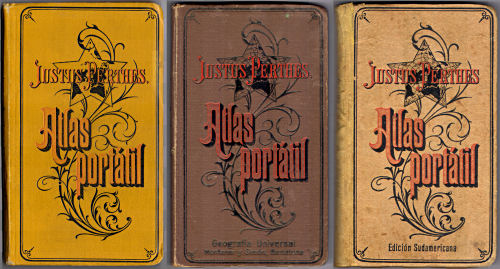
Voorkant banden 1894, 1910, 1921 - Kenmerkend voor deze reeks is de decoratieve voorkant van de band, met de titel in sierletters op een achtergrond van een stervormige wereldkaart en een plantaardig motief.
- Het nummer van de druk van de Spaanstalige uitgaven is niet hetzelfde als het nummer van de Duitse uitgaven. Op de titelpagina wordt wel steeds vermeld op welke druk van de Duitse uitgave de atlas is gebaseerd. Zie ook de lijst van uitgaven.
- In ieder geval in 1904 is er een Chileense uitgave verschenen. Deze heeft dezelfde inhoud als de Spaanse uitgave (28 kaarten). Op de titelpagina staat onder 'Gotha: Justus Perthes' nog vermeld 'Santiago de Chile: Librería Alemana de José Ivens. 1904.'
- Vanaf ongeveer 1910 – misschien al eerder – verscheen ook een Zuid-Amerikaanse uitgave met 4 extra kaarten van Argentinië en Paraguay.
- Op de voorkant de band van de 6e druk (1910) wordt ook de Spaanse uitgever Montaner y Simón uit Barcelona genoemd.
- Naast deze Spaanstalige uitgaven zijn er ook uitgaven in andere talen verschenen
- De auteurs van deze atlas zijn de cartografen Hermann Habenicht (1844-1917) en Bruno Domann (1854-1920). Het geografisch-statistische deel is samengesteld door Hugo Wichmann (1852-1932). Habenicht en Wichmann zijn ook de auteurs van de overeenkomstige Duitse uitgaven.

Band
De uitgaven van vóór en tijdens de eerste wereldoorlog hebben een band van 'calico' (gedrukt katoen) in verschillende kleuren – de band van mijn uitgave uit 1894 is okergeel en die uit 1910 bruin. De uitgaven van na de eerste wereldoorlog hebben een wat soberder beige kartonnen band. Op de voorkant staat de titel "Justus Perthes. Atlas portátil" in sierletters op een achtergrond van een stervormige wereldkaart en een plantaardig motief. De titel staat ook op de rug. Bij de latere uitgaven staat op de achterkant onderaan de tekst "Justus Perthes. Buchbinderei". Bij de uitgaven van na de eerste wereldoorlog ontbreekt de tekst op de achterkant weer.
Op de schutbladen wordt reclame gemaakt voor verwante uitgaven van Justus Perthes, zoals
- de Atlas antiquus: Atlas van de Oudheid in zakformaat
- de Spaanstalige uitgave van de 9e druk van Stielers Hand-Atlas en de kaarten op linnen die samengesteld zijn uit bladen uit die atlas
- de Spaanstalige "Atlas mural metódico" van Sydow-Habenicht, ook bekend als "Methodischer Wandatlas": 16 oro-hydrografische wandkaarten voor scholen
Zie ook de pagina met plaatjes.
Inhoud
De atlas bevat een titelpagina, 1 bladzijde inhoudsopgave, 2 bladzijden voorwoord en 32 bladzijden geografisch-statistische tekst. Tenslotte zijn er de 28 kaarten met afmetingen 19,5 × 17 cm, in kleur, enkelzijdig gedrukt op steviger papier dan dat van de tekstpagina's. De Zuid-Amerikaanse uitgave heeft nog 4 extra kaarten. Er is geen plaatsnamenregister – de Italiaanse uitgave heeft dat wel.
De 1e druk van de atlas (1894) begint met een wereldkaart en een kaart van Europa. Daarna zijn 5 kaarten van Spanje en koloniën en Portugal (plattegronden van Lissabon en Madrid staan op de kaart van Marokko en Algerije), 8 kaarten van de andere landen in Europa, 3 van Azië, 2 van Afrika, 1 van Australië, 5 van Latijns-Amerika en 2 van Noord-Amerika. De Zuid-Amerikaanse uitgave heeft daarna 4 kaarten van Argentinië en Paraguay (met een plattegrond van de hoofdstad Asunción).
In 1898 verloor Spanje de Spaans-Amerikaanse Oorlog en de meeste koloniën: Cuba, Puerto Rico en de Filippijnen. Veel eilanden in de Grote Oceaan (Carolinen, Noordelijke Marianen) zijn toen aan Duitsland verkocht. In latere uitgaven, in ieder geval in 1910, is daarom kaart nummer 7 van de vroegere Spaanse koloniën als nummer 28 naar het einde van de atlas verplaatst. De oorspronkelijke kaarten 8-28 zijn daarbij hernummerd tot 7-27. Zie voor de details de inhoudsopgave.
Vanwege het formaat van de kaarten is de schaal klein. Zo hebben de overzichtskaarten van de werelddelen de schaal 1:60.000.000 (Europa 1:30.000.000). De andere schalen zijn daar veelvouden van, zoals 1:7.500.000 (de meeste landen in Europa en Latijns-Amerika). De deelkaarten van het Iberisch Schiereiland zijn overgenomen uit Stielers Hand-Atlas en hebben een iets afwijkende schaal van 1:3.700.000 (dus niet 1:3.750.000). Zie voor de details de lijst van kaarten, bijkaarten en schaal. Ondanks die kleine schaal staan er veel gegevens op de kaarten zonder dat ze overvol zijn.
De kaarten zijn vervaardigd in kopergravure en lithografisch gedrukt. In de eerste uitgaven lijkt de kleur met de hand aangebracht, daarna in druk. Het papier heeft vanaf die tijd ook wat meer glans. Bovenaan de kaart staan steeds de naam van het blad, de tekst "Atlas portátil" en het nummer van het blad. Onderaan staan de schaal, de tekst "Gotha: Justus Perthes" en een schaalstok. Gegevens over cartografen of graveurs ontbreken (behalve op de kaart van Paraguay, getekend door Bruno Domann).
In mijn exemplaar van de 1e druk (1894) staan er in Romeinse cijfers graveerdata rechtsonder op bijna alle kaarten, in een code zoals II IV voor februari 1894. De enige andere voorkomende code is overigens III IV. Zie de lijst van kaarten en datering. In andere uitgaven heb ik die data niet meer gezien.
Uitgaven
Deze reeks loopt van de 1e druk (niet als zodanig aangegeven, 1894) tot en met de 11e druk (1921). Er zijn in ieder geval Zuid-Amerikaanse uitgaven uit 1914 (8e druk), 1916 (9e druk) en 1921 (11e druk). Details staan in de lijst met uitgaven. De opzet van de atlas is in die periode van bijna 30 jaar nauwelijks veranderd. De kaarten werden wel regelmatig geactualiseerd.
Na 1898 is de kaart van de (vroegere) Spaanse koloniën naar achteren verplaatst waardoor de nummering van de kaarten is veranderd. De uitsnede van de kaart van Midden-Argentinië is, in ieder geval in de 6e druk (1910), gewijzigd waardoor ook Uruguay er helemaal op past.
In de uitgaven van na de eerste wereldoorlog zijn de nieuwe grenzen in rood op het oude kaartbeeld afgedrukt; die uitgaven zitten ook in een soberder band en het papier is van matige kwaliteit. Zie ook de pagina met plaatjes, en de aparte pagina's voor de uitgaven van 1894, 1910 en 1921.
Vergelijking met de Duitse uitgave
In de Spaanstalige uitgaven (met 28/32 kaarten) staan 20 kaarten die ook in de Duitse uitgave (24 kaarten) voorkomen. Van de Duitse uitgave zijn de 3 deelkaarten van Duitsland en de kaart van Zweden, Noorwegen en Denemarken vervallen. De uitsnede van de overzichtskaart van Duitsland is verschoven waardoor ook Denemarken op die kaart past. Scandinavië is in de Spaanstalige uitgaven alleen nog te vinden op de kaart van Rusland, die daarvoor ook een stukje verschoven is.
Ook bij de bijkaarten is een en ander gewijzigd. De hoofdkaart van Spanje en Portugal heeft hier bijkaarten van Madeira en de Kaapverdische Eilanden. Op de kaart van Afrika zijn twee van de drie bijkaarten van de Duitse koloniën weggelaten; de derde is vervangen door een bijkaart van Spaans Guinea; in latere uitgaven zijn de Canarische Eilanden toegevoegd. Op de kaart van Oceanië zijn de bijkaarten van Samoa en Hawaï vervangen door kaarten van enkele – tot 1898 – Spaanse eilanden.
De 8 kaarten die niet in de Duitse uitgave voorkomen, zijn de 3 deelkaarten van het Iberisch Schiereiland, de kaart van de (vroegere) Spaanse koloniën, de kaart van Marokko en Algerije met plattegronden van Lissabon en Madrid, en 3 deelkaarten van Latijns-Amerikaanse landen. Deze 8 kaarten zijn grotendeels ontleend aan de 8e druk van Stielers Hand-Atlas. Dat geldt ook voor de 3 extra kaarten van Argentinië in de Zuid-Amerikaanse uitgave, maar niet voor de kaart van Paraguay.
Zie voor alle details
- de vergelijkende tabellen
- de lijst met verwijzingen naar Stielers Hand-Atlas
Er is ook een pagina met plaatjes van de Spaanse uitgave uit 1894 en de Duitse uit 1888 ter vergelijking naast elkaar.
Alle teksten en plaatsnamen zijn natuurlijk in het Spaans vertaald. De meeste namen zijn, ook zonder veel kennis van het Spaans, vrij eenvoudig te herkennen. Verrassend is wel de Spaanse naam Puerto Cruz voor Willemstad op Curaçao.
Geraadpleegde exemplaren
- Spaanse uitgaven: 1894, 1910
- Zuid-Amerikaanse uitgave: 1921
Justus Perthes. Atlas portátil, 1st-11th editions (1894-1921)
- Below is a description of the Spanish and South American versions of the
atlas. Related pages
- Pictures of the atlas
- Tables and lists to the atlas
- Comparison (pictures) with the German version (1884-1923)
- Title description
- Title: Justus Perthes Atlas Portátil
Publisher: Justus Perthes, Gotha
Year: 1894-1921 (1st-11th editions) - Title page Spanish version (1st edition, 1894):
Justus Perthes Atlas Portátil
Arreglado y traducido de la 30ª edición alemana
de H. Habenicht por Br. Domann.
28 mapas coloridos grabados en cobre.
Con noticias geográfico-estadísticas
por H. Wichmann.
Gotha: Justus Perthes. 1894. Translation:
Justus Perthes Pocket Atlas
Arranged and translated from the 30th German edition
from H. Habenicht by Br. Domann.
28 maps engraved in copper.
With geographical and statistical notes
by H. Wichmann.
Gotha: Justus Perthes. 1894. - Title page Chilean version (3rd edition,
1904) courtesy of Rob Segers:
Justus Perthes Atlas Portátil
Arreglado y traducido de la 41ª edición alemana
de H. Habenicht por Br. Domann.
28 mapas coloridos grabados en cobre.
Con noticias geográfico-estadísticas
por H. Wichmann.
Tercera edición.
Gotha: Justus Perthes.
Santiago de Chile: Librería Alemana de José Ivens. 1904. Translation:
Justus Perthes Pocket Atlas
Arranged and translated from the 41st German edition
from H. Habenicht by Br. Domann.
28 maps engraved in copper.
With geographical and statistical notes
by H. Wichmann.
Third edition.
Gotha: Justus Perthes.
Santiago de Chile: Librería Alemana de José Ivens. 1904. - Title page Spanish version (6th edition, 1910):
Justus Perthes Atlas Portátil
Arreglado y traducido de la 47ª edición alemana
por H. Habenicht y Br. Domann.
28 mapas coloridos grabados en cobre.
Con noticias geográfico-estadísticas
por H. Wichmann.
Sexta Edición.
Gotha, Alemania. Justus Perthes. 1910. Translation:
Justus Perthes Pocket Atlas
Arranged and translated from the 47th German edition
by H. Habenicht and Br. Domann.
28 maps engraved in copper.
With geographical and statistical notes
by H. Wichmann.
Sixth edition.
Gotha, Germany. Justus Perthes. 1910. - Title page South American version (11th edition, 1921):
Justus Perthes Atlas Portátil
Arreglado y traducido de la 57ª edición alemana
por H. Habenicht y Br. Domann
28 mapas coloridos grabados en cobre
Con noticias geográfico-estadísticas
por H. Wichmann
Undécima Edición
Gotha: Justus Perthes 1921
Edición sudamericana Translation:
Justus Perthes Pocket Atlas
Arranged and translated from the 57th German edition
by H. Habenicht and Br. Domann
28 maps engraved in copper
With geographical and statistical notes
by H. Wichmann
Eleventh edition.
Gotha: Justus Perthes 1921
South American edition -
This is the first series of Spanish language versions of Justus Perthes' Taschen-Atlas. These versions are based on the German Taschen-Atlas from the 1884-1923 period (20th-59th editions).
Justus Perthes. Atlas portátil
Front covers 1894, 1910, 1921 - The atlases of this series are characterized by their decorative front cover, with ornamental lettering on a background of a star-shaped world map and a vegetal design.
- The edition number of Spanish language versions is not the same as the number of the German versions. On the title page the number of the corresponding German edition is always mentioned. See also the list of editions.
- With certainty in 1904 a Chilean version of the atlas was published. It has the same contents as the Spanish version (28 maps). Below 'Gotha: Justus Perthes' on the title page the Chilean publisher is mentioned: 'Santiago de Chile: Librería Alemana de José Ivens. 1904.'
- From around 1910 – maybe earlier – a South American version was published, with 4 additional maps of Argentina and Paraguay.
- The front cover of the 6th edition (1910) also mentions the Spanish publisher Montaner y Simón from Barcelona.
- Besides these Spanish language versions there are also versions in other languages
- The authors of this atlas are the cartographers Hermann Habenicht (1844-1917) and Bruno Domann (1854-1920). The geographical and statistical text has been compiled by Hugo Wichmann (1852-1932). Habenicht and Wichmann are also the authors of the corresponding German versions.
- Title: Justus Perthes Atlas Portátil
- Binding
- The editions before and during the First World War have a calico binding in several colors – the binding of my 1894 edition is yellow ochre and the 1910 binding brown. The editions after the First World War have a more austere beige cardboard binding. On the front cover is the title "Justus Perthes. Atlas portátil" in ornamental lettering on a background of a star-shaped world map and a vegetal design. The title is on the spine as well. The back covers of later editions have the text "Justus Perthes. Buchbinderei" in the lower margin. This text is missing in the postwar editions.
- The endpapers contain advertising for related publications from Justus
Perthes, such as
- the Atlas antiquus: Pocket Atlas of the Ancient World
- the Spanish language version of the 9th edition of Stielers Hand-Atlas and the maps that were made by joining together sheets from that atlas
- the Spanish language "Atlas mural metódico" by Sydow-Habenicht, also known as "Methodischer Wandatlas": 16 oro-hydrographical wall maps for schools
- Contents
- The atlas has a title page, one page with the table of contents, a preface of 2 pages and 32 pages of geographical and statistical data. Thereafter are the 28 maps measuring 19.5 × 17 cm, in color, printed on one side only on heavier paper than the text pages. The South American version has 4 additional maps. There is no index – the Italian version does have one.
- The 1st edition (1894) starts with a world map and a map of Europe. Thereafter are 5 maps of Spain and its colonies and Portugal (plans of Lisbon and Madrid are on the map of Morocco and Algeria), 8 maps of the other countries in Europe, 3 of Asia, 2 of Africa, 1 of Australia, 5 of Latin America and 2 of North America. The South American version has a supplement with 4 maps of Argentina and Paraguay (with an inset of the capital Asunción).
- In 1898 Spain lost the Spanish-American War and most of its colonies: Cuba, Puerto Rico and the Philippines. Many islands in the Pacific (Caroline Islands, Northern Mariana Islands) were sold to Germany. In later editions, with certainty in 1910, map number 7 of the former Spanish colonies has therefore been moved to the end of the atlas as map number 28. The original maps 8-28 have been renumbered to 7-27. Details can be found in the table of contents.
- Because of the map size the scales are small. The general maps of the continents have a scale of 1:60,000,000 (Europe 1:30,000,000). The other scales are multiples of this, such as 1:7,500,000 (most countries in Europe and Latin America). The regional maps of Spain have been derived from Stielers Hand-Atlas and have a slightly different scale of 1:3,700,000 (not 1:3,750,000). Details can be found in the list of maps, inset maps and scale. In spite of the small scale the maps contain a lot of information without being overfilled.
- The maps have been produced in copper engraving and were printed lithographically. In the first editions they seem hand colored; thereafter the color is printed. The paper is also a bit glossier in these later editions. In the upper margin of the maps are the sheet name, the text "Atlas portátil" and the sheet number. In the lower margin are the scale, the text "Gotha: Justus Perthes" and a linear scale. No names of cartographers or engravers are mentioned (except for the map of Paraguay, drawn by Bruno Domann).
- In my copy of the 1st edition (1894) there are engraving dates in the lower right of the map, encoded like II IV for February 1894. The only other code, by the way, is III IV. See also the list of maps and date. I haven't seen such dates in later editions.
- Editions
- This series contains the 1st through 11th editions (1894-1921) – the 1st edition is not indicated as such. The existence of South American versions from 1914 (8th edition), 1916 (9th edition) and 1921 (11th edition) is certain. Details can be found in the list of editions. The design of the atlas has not changed in those nearly 30 years. The maps have been updated regularly.
- After 1898 the map of the (former) Spanish colonies has been moved to the back of the atlas, causing changes in the map numbering. The cut-out of the map of Central Argentina has changed, with certainty in the 6th edition (1910), in order to show Uruguay completely.
- In the postwar editions the new borders are printed in red on the old map image; those editions also have a more austere binding and the paper has a poor quality. See also the pictures page, and the separate pages for the editions of 1894, 1910 and 1921.
- In comparison with the German version
- The Spanish language versions (with 28/32 maps) contain 20 maps that can also be found in the German version (24 maps). The 3 regional maps of Germany and the map of Sweden, Norway and Denmark were omitted. The cut-out of the general map of Germany has shifted in order to fit Denmark on that map. In the Spanish language version Scandinavia can only be found on the map of Russia, also slightly shifted.
- There are also some changes in the inset maps. In the Spanish version of the atlas the general map of Spain and Portugal has insets of Madeira and the Cape Verde Islands. On the map of Africa two out of three inset maps of German colonies have been omitted; the third is replaced with an inset of Spanish Guinea; in later editions the Canary Islands were added. On the map of Oceania the inset maps of Samoa and Hawaii are replaced with insets of some – until 1898 – Spanish islands.
- The 8 maps not present in the German version are 3 regional maps of the Iberian Peninsula, the map of the (former) Spanish colonies, the map of Morocco and Algeria with plans of Lisbon and Madrid, and 3 regional maps of Latin American countries. These 8 maps are largely derived from the 8th edition of Stielers Hand-Atlas. This also applies to the 3 additional maps of Argentina in the South American version, but not to the map of Paraguay.
- Details can be found in
- the comparison tables
- the list of references to Stielers Hand-Atlas
- All texts and place names have been translated into Spanish of course. Most names are rather easily recognizable, even without an extensive knowledge of Spanish. Surprisingly the Spanish name for Willemstad (Curaçao) is Puerto Cruz.
Copies consulted
- Spanish versions: 1894, 1910
- South American version: 1921
© M. Witkam, 2011
![]()
![]()