Justus Perthes' Taschen-Atlas, 20e-59e druk (1884-1923)
See below for (a summary of) this text in English.
Hieronder staat de beschrijving van de Duitse en Oostenrijkse uitgaven van de atlas. Daarbij horen ook de volgende pagina's
- Voorwoord van de atlas
- Plaatjes van de atlas
- Tabellen en lijsten bij de atlas
- Vergelijking (plaatjes) met de 1e-19e druk (1845-1883)
en ook
- Plaatjes van de 24e druk van de atlas (Duitse uitgave, 1888)
- Plaatjes van de 39e druk van de atlas (Oostenrijke uitgave, 1902)
- Plaatjes van de 50e druk van de atlas (Duitse uitgave, 1913)
- Plaatjes van de 57e druk van de atlas (Duitse uitgave, 1921)
Titelgegevens
Titel: Taschen-Atlas
Uitgever: Justus Perthes, Gotha
Jaar: 1884-1923 (20e-59e druk)
Titelpagina Duitse uitgave (21e druk, 1884):
Justus Perthes' Taschen-Atlas
21. Auflage
Vollständig neu bearbeitet von Hermann Habenicht.
24 kolorierte Karten in Kupferstich.
Mit einem geographisch-statistischen Text.
Gotha: Justus Perthes. 1884
Vertaling:
Justus Perthes' Zakatlas
21e druk
Volledig nieuw bewerkt door Hermann Habenicht.
24 gekleurde kaarten in kopergravure.
Met een geografisch-statistische tekst.
Gotha, Justus Perthes. 1884
Titelpagina Duitse uitgave (24e druk, 1888):
Justus Perthes' Taschen-Atlas
24. Auflage
Vollständig neu bearbeitet von Hermann Habenicht.
24 kolorierte Karten in Kupferstich.
Mit geographisch-statistischen Notizen.
Gotha: Justus Perthes. 1888.
Titelpagina Duitse uitgave (29e druk, 1893):
Justus Perthes' Taschen-Atlas
29. Auflage
Vollständig neu bearbeitet von Hermann Habenicht.
24 kolorierte Karten in Kupferstich.
Mit geographisch-statistischen Notizen von H. Wichmann.
Gotha: Justus Perthes. 1893.
Titelpagina Oostenrijkse uitgave (39e druk, 1902):
Justus Perthes' Taschen-Atlas
39. Auflage
Vollständig neu bearbeitet von Hermann Habenicht.
24 kolorierte Karten in Kupferstich.
Mit geographisch-statistischen Notizen von H. Wichmann.
Sonderausgabe mit vier weiteren Karten für die
Österreichisch-Ungarische Monarchie.
Gotha: Justus Perthes. 1902.
Speciale uitgave met vier extra kaarten voor de Oostenrijks-Hongaarse monarchie.
Titelpagina "Franse" uitgave (42e druk, 1905):
Justus Perthes' Taschen-Atlas
42. Auflage
Vollständig neu bearbeitet von Hermann Habenicht.
24 kolorierte Karten in Kupferstich.
Mit geographisch-statistischen Notizen von H. Wichmann.
Gotha: Justus Perthes.
Paris: Haar & Steinert. 21 rue Jacob.
1905.
Titelpagina Duitse uitgave (54e druk, 1917):
Justus Perthes' Taschen-Atlas
54. Auflage
Vollständig neu bearbeitet von Hermann Habenicht
24 kolorierte Karten in Kupferstich
Mit geographisch-statistischen Notizen von H. Wichmann
Gotha: Justus Perthes 1917
met handstempel
Z.XI.
-
Dit is de tweede reeks van wereldatlassen in zakformaat van Justus Perthes. Deze atlassen zijn onder verschillende titels tot 1967 uitgegeven. Zie ook het overzicht van alle zakatlassen van Justus Perthes.
 Justus Perthes' Taschen-Atlas
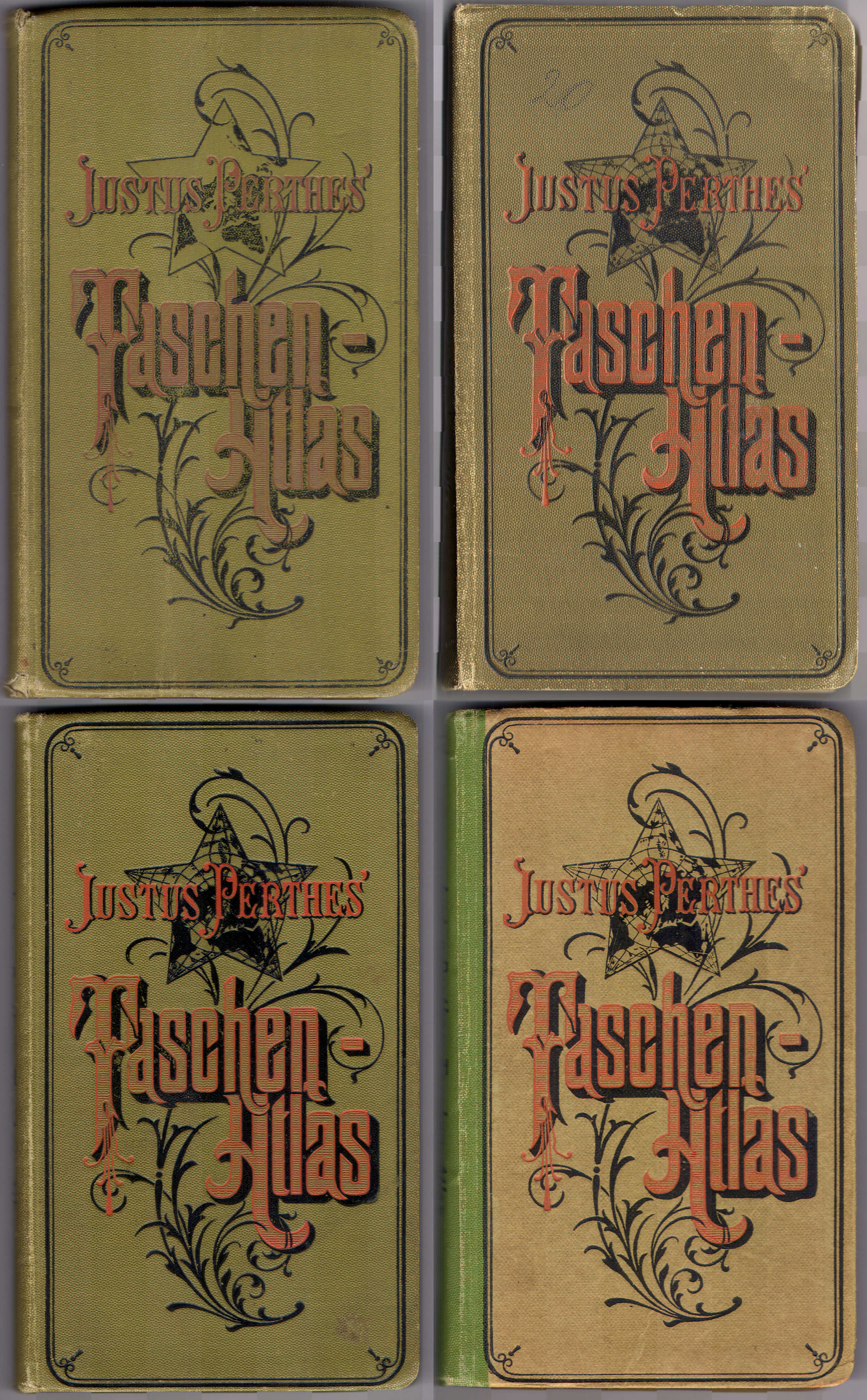
Voorkant banden 1888, 1902, 1913, 1921 - Kenmerkend voor deze reeks is de decoratieve voorkant van de band, met de titel in sierletters op een achtergrond van een stervormige wereldkaart en een plantaardig motief.
- Op deze pagina's worden de Duitstalige uitgaven behandeld
- uitgaven voor Duitsland
- uitgaven voor Oostenrijk-Hongarije (met 4 extra kaarten)
- Italiaanse uitgaven
- Spaanstalige uitgaven (Spanje, Zuid-Amerika)
- één Braziliaanse uitgave
- De auteur van deze atlas is de Hermann Habenicht (1844-1917), in dezelfde periode ook verantwoordelijk voor de Taschen-Atlas vom Deutschen Reich (zakatlas van Duitsland) en de See-Atlas (zeeatlas in zakformaat). De geografisch-statistische tekst is samengesteld door Hugo Wichmann (1852-1932).
Band
De atlas heeft een band van groen 'calico' (gedrukt katoen) van 10,5 × 17,5 cm (B × H). Op de voorkant staat de titel "Justus Perthes' Taschen-Atlas" in sierletters op een achtergrond van een stervormige wereldkaart en een plantaardig motief. In ieder geval vanaf 1896 – misschien al een jaar eerder – heeft die wereldkaart lengte- en breedtecirkels, en staat de titel ook op de rug van de band. Vanaf 1907 staat op de achterkant van de band de tekst "Justus Perthes. Buchbinderei". De uitgaven van na de eerste wereldoorlog hebben een wat soberder kartonnen band. Bij die uitgaven ontbreekt de tekst op de achterkant weer.
Vanaf 1896 – of een jaar eerder – wordt op de schutbladen reclame gemaakt voor verwante uitgaven van Justus Perthes, zoals
- de verschillende zakatlassen (in aantal toenemend van 4 tot 6) met het bewaardoosje voor de hele set
- de 9e druk van Stielers Hand-Atlas in verschillende varianten en met diverse banden
Zie ook de pagina met plaatjes.
Inhoud
De atlas bevat een titelpagina, 1 bladzijde inhoudsopgave en 2 bladzijden voorwoord; verder de geografisch-statistische tekst, in de eerste uitgaven 28 bladzijden, vanaf 1893 opeens 64 bladzijden en vanaf 1902 zelfs 76. Daarna komen de 24 kaarten – of 28 voor de Oostenrijkse uitgave – met afmetingen 19,5 × 17 cm, in kleur, enkelzijdig gedrukt op steviger papier dan dat van de tekstpagina's. Er is geen plaatsnamenregister – de Italiaanse uitgave heeft dat wel.
De atlas begint met een wereldkaart. Daarna zijn er 14 kaarten van Europese landen, met ook 3 deelkaarten van Duitsland. In de Oostenrijkse uitgave zijn daar 4 deelkaarten van Oostenrijk-Hongarije aan toegevoegd die ontleend zijn aan Stielers Hand-Atlas (vandaar ook de iets afwijkende schaal). Tenslotte zijn er 3 kaarten van Azië, 1 van Afrika en 1 van Australië, en 4 van Noord- en Zuid-Amerika. Zie ook de inhoudsopgave.
Vanwege het formaat van de kaarten is de schaal klein. Zo hebben de overzichtskaarten van de werelddelen de schaal 1:60.000.000 (Europa 1:30.000.000). De andere schalen zijn daar veelvouden van, zoals 1:7.500.000 (de meeste landen in Europa) en 1:3.750.000 (Duitsland); maar de extra kaarten van Oostenrijk-Hongarije hebben de schaal 1:3.700.000. Zie voor de details de lijst van kaarten, bijkaarten en schaal. Ondanks die kleine schaal staan er veel gegevens op de kaarten zonder dat ze overvol zijn. Een indicatie daarvan is het register van de Italiaanse uitgave (ook met 24 kaarten), dat 50 bladzijden beslaat en ongeveer 9000 namen bevat.
De kaarten zijn vervaardigd in kopergravure en lithografisch gedrukt. Tot ongeveer 1900 lijkt de kleur met de hand aangebracht, daarna in druk. Het papier heeft vanaf die tijd ook wat meer glans. Bovenaan de kaart staan steeds de naam en het nummer van het blad. Onderaan staan de schaal, de tekst "Gotha: Justus Perthes" en een schaalstok. Gegevens over cartografen of graveurs ontbreken.
Vanaf 1893 staan er in Romeinse cijfers graveerdata rechtsonder op de kaart, in een code zoals II III voor februari 1893. In de uitgave van 1893 is dat alleen op de kaarten 4, 8, 12, 16, 20 en 24 – de veelvouden van 4. In de uitgave van 1896 staan ze op bijna alle kaarten. In 1898 zijn deze data weer verdwenen, maar ze staan wel op de extra kaarten van Oostenrijk-Hongarije in de Oostenrijkse uitgaven van 1902, 1907 en 1914 (overigens in al deze uitgaven met dezelfde datering III II = maart 1902). Zie voor de details de lijst van kaarten en datering.
Uitgaven
In de periode 1884-1923 zijn de 20e tot en met de 59e druk van de atlas verschenen, dus zowat elk jaar een nieuwe druk; zie de lijst met uitgaven. De opzet van de atlas is in die periode van 40 jaar niet veranderd. De kaarten werden wel regelmatig geactualiseerd, wat bijvoorbeeld goed te zien is op de kaarten van de Balkan en van Afrika.
In de uitgaven van na de eerste wereldoorlog zijn de nieuwe grenzen in rood op het oude kaartbeeld afgedrukt; die uitgaven zitten ook in een soberder band en het papier is van matige kwaliteit. Zie ook de pagina met plaatjes, en de aparte pagina's voor de uitgaven van 1888, 1902, 1913 en 1921.
Vergelijking met de 1e-19e druk
Vergeleken met de eerdere uitgaven is de atlas volledig vernieuwd: nieuwe kaarten, nieuwe druktechniek, kleuring. Dat was ook wel nodig want de 1e druk dateerde al van 1845 en de kaarten waren daarna niet wezenlijk vernieuwd. Ook de verwijzing naar Stielers Hand-Atlas, zoals in de vorige reeks, ontbreekt. Een vergelijking van deze reeks met de vorige is dus nauwelijks zinvol. Voor de volledigheid is er een pagina met naast elkaar plaatjes van de kaarten van de uitgaven van 1888 (24e druk) en 1878 (15e druk).
Geraadpleegde exemplaren
- Duitse uitgaven: 1884, 1886, 1888, 1890, 1893, 1896, 1901, 1903, 1905, 1908, 1912, 1913, 1914, 1916, 1917, 1921, 1922
- Oostenrijkse uitgaven: 1902, 1907, 1914
Justus Perthes' Taschen-Atlas, 20th-59th editions (1884-1923)
- Below is a description of the German and Austrian versions of the atlas in
keywords. Related pages
- Preface to the atlas
- Pictures of the atlas
- Tables and lists to the atlas
- Comparison (pictures) with the 1st-19th editions (1845-1883)
- and also
- Title description
- Title: Taschen-Atlas
Publisher: Justus Perthes, Gotha
Year: 1884-1923 (20th-59th editions) - Title page German version (21st edition, 1884):
Justus Perthes' Taschen-Atlas
21. Auflage
Vollständig neu bearbeitet von Hermann Habenicht.
24 kolorierte Karten in Kupferstich.
Mit einem geographisch-statistischen Text.
Gotha: Justus Perthes. 1884 Translation:
Justus Perthes Pocket Atlas
21st edition
Completely reworked by Hermann Habenicht.
24 colored maps in copper engraving.
With a geographical and statistical text.
Gotha, Justus Perthes. 1884 - Title page German version (24th edition, 1888):
Justus Perthes' Taschen-Atlas
24. Auflage
Vollständig neu bearbeitet von Hermann Habenicht.
24 kolorierte Karten in Kupferstich.
Mit geographisch-statistischen Notizen.
Gotha: Justus Perthes. 1888. - Title page German version (29th edition, 1893):
Justus Perthes' Taschen-Atlas
29. Auflage
Vollständig neu bearbeitet von Hermann Habenicht.
24 kolorierte Karten in Kupferstich.
Mit geographisch-statistischen Notizen von H. Wichmann.
Gotha: Justus Perthes. 1893. - Title page Austrian version (39th edition, 1902):
Justus Perthes' Taschen-Atlas
39. Auflage
Vollständig neu bearbeitet von Hermann Habenicht.
24 kolorierte Karten in Kupferstich.
Mit geographisch-statistischen Notizen von H. Wichmann.
Sonderausgabe mit vier weiteren Karten für die Österreichisch-Ungarische Monarchie.
Gotha: Justus Perthes. 1902. Special edition with four additional maps for the Austro-Hungarian Monarchy. - Title page "French" version (42nd edition, 1905):
Justus Perthes' Taschen-Atlas
42. Auflage
Vollständig neu bearbeitet von Hermann Habenicht.
24 kolorierte Karten in Kupferstich.
Mit geographisch-statistischen Notizen von H. Wichmann.
Gotha: Justus Perthes.
Paris: Haar & Steinert. 21 rue Jacob.
1905. - Title page German version (54th edition, 1917):
Justus Perthes' Taschen-Atlas
54. Auflage
Vollständig neu bearbeitet von Hermann Habenicht
24 kolorierte Karten in Kupferstich
Mit geographisch-statistischen Notizen von H. Wichmann
Gotha: Justus Perthes 1917 with hand stamp Z.XI. -
This is the second series of pocket size world atlases from Justus Perthes. These atlases have been published until 1967 under several different titles. See also the overview of all pocket atlases from Justus Perthes.
Justus Perthes' Taschen-Atlas
Front covers 1888, 1902, 1913, 1921 - The atlases of this series are characterized by their decorative front cover, with ornamental lettering on a background of a star-shaped world map and a vegetal design.
- On these pages the German language versions are described
- editions for Germany
- editions for Austria-Hungary (with 4 additional maps)
- Italian versions
- Spanish language versions (Spain, South America)
- one Brazilian version
- The author of this atlas is Hermann Habenicht (1844-1917), in the same period also responsible for the Taschen-Atlas vom Deutschen Reich (pocket atlas of Germany) and the See-Atlas (pocket size sea atlas). The geographical and statistical text has been compiled by Hugo Wichmann (1852-1932).
- Title: Taschen-Atlas
- Binding
- The atlas has a green calico binding measuring 10.5 × 17.5 cm (W × H). On the front cover is the title "Justus Perthes' Taschen-Atlas" in ornamental lettering on a background of a star-shaped world map and a vegetal design. From 1896 – maybe a year earlier already – this world map has longitude and latitude circles and a title on the spine. From 1907 the back cover has the text "Justus Perthes. Buchbinderei". The editions after the First World War have a more austere cardboard binding, without text on the back cover.
- From 1896 – or a year earlier – the endpapers contain advertising for
related publications from Justus Perthes, such as
- the various pocket atlases, increasing in number from 4 to 6, with the storage box for the entire set
- the 9th edition of Stielers Hand-Atlas in several variants and with various bindings
- Contents
- The atlas has a title page, one page with the table of contents, a preface of 2 pages and a text section with geographical and statistical data that has 28 pages in the early editions, increasing to 64 pages in 1893 and even 76 in 1902. Thereafter are the 24 maps – 28 in the Austrian version – measuring 19.5 × 17 cm, in color, printed on one side only on heavier paper than the text pages. There is no index – the Italian version does have one.
- First in the atlas is a world map. Thereafter are 14 maps of countries in Europe, with 3 regional maps of Germany. The Austrian version has 4 additional maps of Austria-Hungary that have been derived from Stielers Hand-Atlas (hence the slightly different scale). In the end are 3 maps of Asia, 1 of Africa and Australia each, and 4 of the Americas. See also the table of contents.
- Because of the map size the scales are small. The general maps of the continents have a scale of 1:60,000,000 (Europe 1:30,000,000). The other scales are multiples of this, such as 1:7,500,000 (most countries in Europe) and 1:3,750,000 (Germany); but the additional maps of Austria-Hungary have a scale of 1:3,700,000. Details can be found in the list of maps, inset maps and scale. In spite of the small scale the maps contain a lot of information without being overfilled. An indication of this is the index of the Italian version (also with 24 maps) that has 50 pages and contains some 9000 names.
- The maps have been produced in copper engraving and were printed lithographically. Until around 1900 they seem hand colored; thereafter the color is printed. The paper is also a bit glossier in these later editions. In the upper margin of the maps are the name and the sheet number. In the lower margin are the scale, the text "Gotha: Justus Perthes" and a linear scale. No names of cartographers or engravers are mentioned.
- From 1893 there are engraving dates in the lower right of the map, encoded like II III for February 1893; in the 1893 edition only on the maps with number 4, 8, 12, 16, 20 and 24 – the multiples of 4. In the 1896 edition almost all maps are dated. In 1898 the engraving dates have disappeared, but they are still present on the additional maps of Austria-Hungary in the Austrian editions of 1902, 1907 and 1917 (in all these editions the same date of III II = March 1902 is given). Details can be found in the list of maps and date.
- Editions
- In the 1884-1923 period, the 20th through the 59th editions of the atlas were published, so there was a new edition almost every year; see the list of editions. The design of the atlas has not changed in those 40 years. The maps have been updated regularly, which is most evident on the maps of the Balkan Peninsula and of Africa.
- In the editions after the First World War, the new borders are printed in red on the old map image; those editions also have a more austere binding and the paper has a poor quality. See also the pictures page, and the separate pages for the editions of 1888, 1902, 1913 and 1921.
- In comparison with the 1st-19th editions
- As compared to the earlier editions the atlas has been renewed completely: new maps, new printing technique, and coloring. This was necessary indeed because the 1st edition was produced in 1845 and the maps had not been renewed substantially afterwards. The reference to Stielers Hand-Atlas, as in the earlier editions, is now missing. So comparing this series with the earlier editions is hardly useful. For completeness there is a page with pictures side by side of the maps in the 24th edition (1888) and the 15th edition (1878).
Copies consulted
- German versions: 1884, 1886, 1888, 1890, 1893, 1896, 1901, 1903, 1905, 1908, 1912, 1913, 1914, 1916, 1917, 1921, 1922
- Austrian versions: 1902, 1907, 1914
© M. Witkam, 2011
![]()
![]()