Giusto Perthes. Atlante tascabile, 1e-3e druk (1891-1912?)
See below for (a summary of) this text in English.
Hieronder staat de beschrijving van de Italiaanse uitgaven van de atlas. Daarbij horen ook de volgende pagina's
- Plaatjes van de atlas
- Tabellen en lijsten bij de atlas
- Vergelijking (plaatjes) met de Duitse uitgave (1884-1923)
en ook
Titelgegevens
Titel: Giusto Perthes. Atlante tascabile
Uitgever: Justus Perthes, Gotha
Jaar: 1891-1912? (1e-3e druk)
Titelpagina (1e druk, 1891):
Atlante tascabile di Ermanno Habenicht.
24 Carte incise su rame.
Con Indice alfabetico dei nomi.
Gotha: Giusto Perthes. 1891.
Torino, Firenze, Roma: Ermanno Loescher.
Palermo: Carlo Clausen.
Vertaling:
Zakatlas door Hermann Habenicht.
24 kaarten gegraveerd in koper.
Met een alfabetisch namenregister.
Gotha: Justus Perthes. 1891.
Turijn, Florence, Rome: Ermanno Loescher.
Palermo: Carlo Clausen.
Titelpagina (3e druk, 1902):
Atlante tascabile di Ermanno Habenicht.
24 Carte incise su rame.
Con Notizie geografiche-statistiche e
Indice alfabetico dei nomi.
Terza edizione.
Gotha: Giusto Perthes.
Torino: Carlo Clausen.
1902.
Vertaling:
Zakatlas door Hermann Habenicht.
24 kaarten gegraveerd in koper.
Met geografisch-statistische aantekeningen en
een alfabetisch namenregister.
Derde druk.
Gotha: Justus Perthes.
Turijn: Carlo Clausen.
1902.
Titelpagina (3e druk, 1912?):
Atlante tascabile di Ermanno Habenicht
24 Carte incise su rame
Con Notizie geografiche-statistiche e Indice alfabetico dei nomi
Terza edizione
Gotha: Giusto Perthes
-
Dit is de Italiaanse uitgave van Justus Perthes' Taschen-Atlas. Deze uitgave is gebaseerd op de Duitse Taschen-Atlas uit de periode 1884-1923 (20e-59e druk).
 Giusto Perthes. Atlante tascabile (1912?)
Band - Naast deze Italiaanse uitgave zijn er ook uitgaven in andere talen
verschenen
- Spaanstalige uitgaven (Spanje, Zuid-Amerika)
- één Braziliaanse uitgave
- Zoals bij de Duitse uitgave is de auteur van deze atlas de cartograaf Hermann Habenicht (1844-1917). Het geografisch-statistische deel is samengesteld door Hugo Wichmann (1852-1932).
- Van deze zakatlas is de 1e druk verschenen in 1891, de 2e in 1900 en de 3e in 1902. Van de 3e druk zijn ook latere uitgaven verschenen. Mijn exemplaar dateert waarschijnlijk uit 1912: Libië wordt – met de hand gekleurd – aangegeven als Italiaans (1912) en op de Balkan lopen de grenzen nog zoals vóór de Balkanoorlogen (1912-1913).
Band
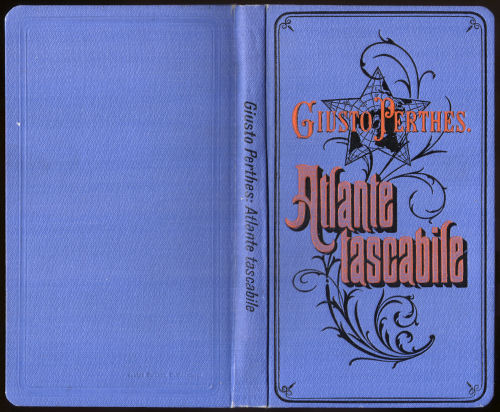
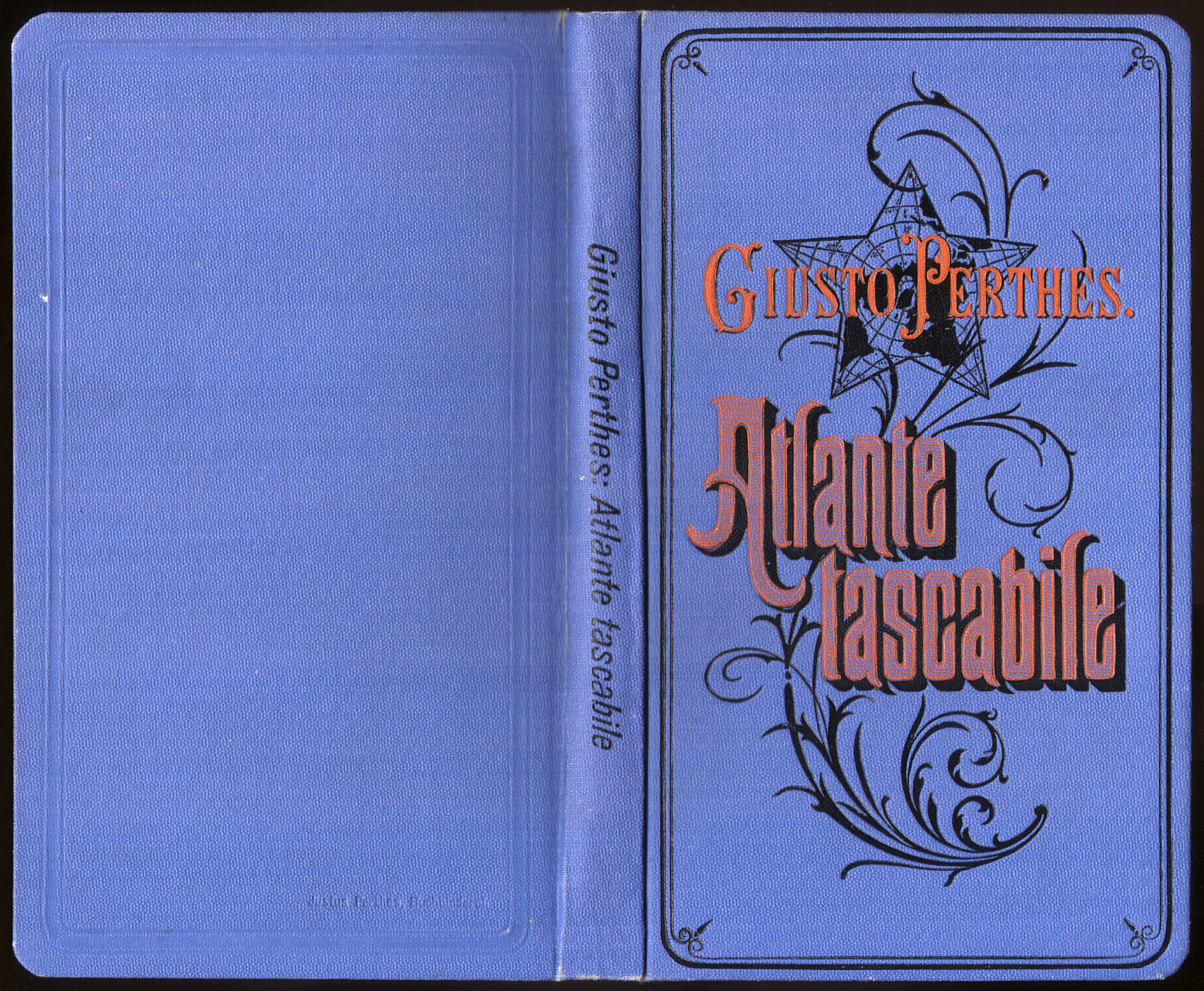
De atlas heeft een band van blauw 'calico' (gedrukt katoen) met afmetingen 10,5 × 17,5 cm (B × H). Op de voorkant staat de titel "Giusto Perthes. Atlante tascabile" in sierletters op een achtergrond van een stervormige wereldkaart en een plantaardig motief. Bij de latere uitgaven staat de titel ook op de rug en staat op de achterkant onderaan de tekst "Justus Perthes. Buchbinderei".
In de uitgave 1912 van de 3e druk wordt op de schutbladen reclame gemaakt voor de Italiaanse uitgave van Stielers Hand-Atlas en voor de grote kaarten op linnen die samengesteld zijn uit losse bladen daarvan. Zie ook de pagina met plaatjes van deze uitgave.
Inhoud
De 1e druk van de atlas (1891) bevat een titelpagina, 1 bladzijde inhoudsopgave en 2 bladzijden voorwoord en uitleg bij het namenregister, het register zelf van 50 bladzijden (met ongeveer 9.000 namen) en 2 bladzijden met reclame voor andere atlassen en kaarten van Justus Perthes. Tenslotte zijn er de 24 kaarten met afmetingen 19,5 × 17 cm, in kleur, enkelzijdig gedrukt op steviger papier dan dat van de tekstpagina's.
In de 3e druk (1902-1912?) is de indeling anders. Na titelpagina, inhoudsopgave en voorwoord (2 bladzijden) komen nu 30 bladzijden met geografisch-statistische aantekeningen, daarna de 24 kaarten en tenslotte het register met 1 bladzijde uitleg, 3 bladzijden met aanvullingen en wijzigingen bij het register van de 2e druk, en 50 bladzijden met namen.
De atlas begint met een wereldkaart en een kaart van Europa. Daarna zijn er 4 kaarten van Italië (een overzichtskaart en drie deelkaarten), 9 van de andere Europese landen, 3 van Azië, 1 van Afrika en 1 van Australië, en 4 van Noord- en Zuid-Amerika. Zie ook de inhoudsopgave.
Vanwege het formaat van de kaarten is de schaal klein. Zo hebben de overzichtskaarten van de werelddelen de schaal 1:60.000.000 (Europa 1:30.000.000). De andere schalen zijn daar veelvouden van, zoals 1:7.500.000 (de meeste landen in Europa) en 1:3.750.000 (Italië). Zie voor de details de lijst van kaarten, bijkaarten en schaal. Ondanks die kleine schaal staan er veel gegevens op de kaarten zonder dat ze overvol zijn.
De kaarten zijn vervaardigd in kopergravure en lithografisch gedrukt. Tot ongeveer 1900 lijkt de kleur met de hand aangebracht, daarna in druk. Het papier heeft vanaf die tijd ook wat meer glans. In de uitgave 1912 zijn wel recente correcties met de hand aangebracht.
Bovenaan de kaart staan steeds de naam van het blad, de tekst "Atlante tascabile" en het nummer van het blad (Tª = Tav. = Tavola). Onderaan staan de schaal, de tekst "Gotha: Giusto Perthes" en een schaalstok. Gegevens over cartografen of graveurs ontbreken. In de 1e druk (1891) staat rechtsonder op de kaarten 4, 8, 12, 16, 20 en 24 – dus de veelvouden van 4 – de graveerdatum III I (maart 1891). In de 3e druk zijn die data weer verdwenen. In de marge staan letters (verticaal) en cijfers (horizontaal) om met behulp van het register de namen op de kaart te kunnen terugvinden.
Uitgaven
Van deze atlas heb ik de 1e druk (niet als zodanig aangegeven) uit 1891 kunnen vinden, de 2e druk uit 1900 en de 3e uit 1902. Van de 3e druk zijn in ieder geval tot in 1912 bijgewerkte uitgaven verschenen, soms zonder jaartal op de titelpagina. De kaarten zijn in alle uitgaven dezelfde maar in latere uitgaven is het geografisch-statistische deel toegevoegd.
Vergelijking met de Duitse uitgave
Het grootste verschil met de Duitse uitgaven is de aanwezigheid van een register – de Duitse zakatlassen hebben dat pas vanaf 1952 – en daarmee de letters en cijfers in de marge van de kaarten. Alles is natuurlijk in het Italiaans vertaald. Verder zijn er 3 deelkaarten van Italië; de deelkaarten van Duitsland uit de Duitse uitgave zijn weggelaten. De overige kaarten komen op een paar kleine details na overeen – op de bijkaarten bij de kaart van Afrika zijn een paar Duitse koloniën vervangen door Italiaanse en, heel subtiel, op de bijkaart van Zuid-Brazilië is sprake van Italiaanse in plaats van Duitse nederzettingen. Zie verder de vergelijkende tabel. Er is ook een pagina met plaatjes van de Italiaanse uitgave uit 1891 en de Duitse uit 1888 ter vergelijking naast elkaar.
Giusto Perthes. Atlante tascabile, 1st-3rd editions (1891-1912?)
- Below is a description of the Italian versions of the atlas. Related pages
- Pictures of the atlas
- Tables and lists to the atlas
- Comparison (pictures) with the German version
- Title description
- Title: Giusto Perthes. Atlante tascabile
Publisher: Justus Perthes, Gotha
Year: 1891-1912? (1st-3rd editions) - Title page (1st edition, 1891):
Atlante tascabile di Ermanno Habenicht.
24 Carte incise su rame.
Con Indice alfabetico dei nomi.
Gotha: Giusto Perthes. 1891.
Torino, Firenze, Roma: Ermanno Loescher.
Palermo: Carlo Clausen. Translation:
Pocket Atlas by Hermann Habenicht.
24 maps engraved in copper.
With an alphabetical index of names.
Gotha: Justus Perthes. 1891.
Turin, Florence, Rome: Ermanno Loescher.
Palermo: Carlo Clausen. - Title page (3rd edition, 1902):
Atlante tascabile di Ermanno Habenicht.
24 Carte incise su rame.
Con Notizie geografiche-statistiche e Indice alfabetico dei nomi.
Terza edizione.
Gotha: Giusto Perthes.
Torino: Carlo Clausen.
1902. Translation:
Pocket Atlas by Hermann Habenicht.
24 maps engraved in copper.
With geographical and statistical notes and an alphabetical index of names.
Third edition.
Gotha: Justus Perthes.
Turin: Carlo Clausen. - Title page (3rd edition, 1912?):
Atlante tascabile di Ermanno Habenicht
24 Carte incise su rame
Con Notizie geografiche-statistiche e Indice alfabetico dei nomi
Terza edizione
Gotha: Giusto Perthes -
This is the Italian version of Justus Perthes' Taschen-Atlas. This version is based on the German Taschen-Atlas from the 1884-1923 period (20th-59th editions).
Giusto Perthes. Atlante tascabile (1912?)
Binding - Besides this Italian version there are also versions in other
languages
- Spanish language versions (Spain, South America)
- one Brazilian version
- As in the German version the author of this atlas is the cartographer Hermann Habenicht (1844-1917). The geographical and statistical text has been compiled by Hugo Wichmann (1852-1932).
- The 1st edition of this pocket atlas was published in 1891 the 2nd in 1900 and the 3rd in 1920. There are also later printings of the 3rd edition. My copy was presumably published in 1912: Libya is – with hand coloring – indicated as Italian (1912) and the boundaries on the Balkan Peninsula predate the Balkan Wars (1912-1913).
- Title: Giusto Perthes. Atlante tascabile
- Binding
- The atlas has a blue calico binding measuring 10.5 × 17.5 cm (W × H). On the front cover is the title "Giusto Perthes. Atlante tascabile" in ornamental lettering on a background of a star-shaped world map and a vegetal design. In later editions the title is also given on the spine and the back cover then has the text "Justus Perthes. Buchbinderei" in the lower margin.
- The endpapers in the 1912 printing of the 3rd edition contain advertising for the Italian version of Stielers Hand-Atlas and the large maps on cloth that are made by joining separate maps from this atlas. See also the pictures page for this edition.
- Contents
- The 1st edition of the atlas (1891) has a title page, one page with the table of contents, 2 pages with the preface and explanations to the index, the index itself of 50 pages (with some 9,000 names) and two pages with advertisement for other atlases and maps from Justus Perthes. Thereafter are the 24 maps measuring 19.5 × 17 cm, in color, printed on one side only on heavier paper than the text pages.
- The 3rd edition (1902-1912?) has a slightly different order. The title page, table of contents and preface (2 pages) are now followed by 30 pages with geographical and statistical notes, then the 24 maps and in the end the index with 1 page of explanation, 3 pages with additions and corrections to the index of the 2nd edition, and 50 pages with names.
- First in the atlas are 2 maps of the world and Europe. Thereafter are 4 maps of Italy (one general maps and three regional maps), 9 maps of the other countries in Europe, 3 maps of Asia, 1 of Africa and Australia each, and 4 of the Americas. See also the table of contents.
- Because of the map size the scales are small. The general maps of the continents have a scale of 1:60,000,000 (Europe 1:30,000,000). The other scales are multiples of this number, such as 1:7,500,000 (most countries in Europe) and 1:3,750,000 (Italy). Details can be found in the list of maps, inset maps and scale. In spite of the small scale the maps contain a lot of information without being overfilled.
- The maps have been produced in copper engraving and were printed lithographically. Until around 1900 they seem hand colored; thereafter the color is printed. The paper is also a bit glossier in these later editions. In the 1912 editions some last minute changes seem to have been done by hand.
- In the upper margin of the maps are the name of the sheet, the text "Atlante tascabile" and the sheet number (Tª = Tav. = Tavola). In the lower margin are the scale, the text "Gotha: Giusto Perthes" and a linear scale. No names of cartographers or engravers are mentioned. In the lower right of some maps in the 1st edition (1891) the engraving date III I (March 1891) is printed. This was done on the maps with numbers 4, 8, 12, 16, 20 and 24 (the multiples of 4). In the 3rd edition these dates have disappeared. In the margin of the maps are letters (vertically) and digits (horizontally) to facilitate finding names on the map with the index.
- Editions
- I have been able to trace the 1st edition (not indicated as such) from 1891, the 2nd from 1900 and the 3rd from 1902. Of this 3rd edition updated printings have been published until at least 1912, sometimes without a year on the title page. The maps are the same in all editions but in later editions the geographical and statistical notes were added.
- In comparison with the German version
- The main difference with the German version is the presence of an index – the German pocket atlases for the first time have one in 1952 – and therefore the letters and digits in the map margins. Of course everything has been translated in Italian. Italy has 3 regional maps; the regional maps of Germany were omitted. The other maps correspond to each other except for a few details – on the insets to the map of Africa some German colonies have been replaced with Italian colonies and, very subtle, the inset maps of South Brazil now shows the Italian instead of the German settlements. Details can be found in the comparison table. There is also a page with pictures of the Italian and German versions side by side for comparison purposes.
© M. Witkam, 2011
![]()
![]()