Kogutowicz-Littke(-Debes): Világatlasz (1912-1914)
See below for (a summary of) this text in English.
Hieronder staat de beschrijving van de atlas. Daarbij horen ook de volgende pagina's
- Plaatjes van de atlas
- Tabellen en lijsten bij de atlas
- Vergelijking (plaatjes) met Debes' Handatlas
Titelgegevens
Titel: Kogutowicz-Littke(-Debes): Világatlasz
Uitgever: Magyar Földrajzi Intézet, Budapest
Jaar: 1912-1914 (datering kaarten)
Titelpagina:
A Magyar Földrajzi Intézet Részvénytársaság világatlasza:
95 fő és 190 melléktérképpel, 130 térképlapon,
kb. 130.000 nevet tartalmazó névjegyzékkel,
terjedelmes és gazdagon illusztrált szöveges résszel
szerkesztik Kogutowicz Károly és Littke Aurél
Vertaling:
De Wereldatlas van het Hongaarse Geografische Instituut N.V.:
met 95 hoofd- en 190 bijkaarten, op 130 kaartbladzijden,
een register met ongeveer 130.000 namen,
een omvangrijk en rijk geïllustreerd tekstdeel
bewerkt door Károly Kogutowicz en Aurél Littke
Titelpagina van het exemplaar (656654317) in de Universitäts- und Forschungsbibliothek Erfurt/Gotha
Titel op map:
Nemcsak disz hanem szükséglet a
Világatlasz minden ember számára
Megrendelhető minden könyvkereskedőnél vagy a kiadó
Magyar Földrajzi Intézet r.t. nál, Budapest v.k. Rudolf-tér.
Vertaling:
Niet alleen decoratief maar een noodzaak de
Wereldatlas voor iedereen
Verkrijgbaar bij elke boekhandel of bij de uitgever
Hongaars Geografisch Instituut N.V., Budapest v.k. Rudolfplein.
r.t. = Részvénytársaság = naamloze vennootschap
- Dit is de, nooit voltooide, Hongaarse uitgave van de Duitse Debes' Handatlas. Dit exemplaar bevat 72 van de geplande 130 bladzijden kaarten; er ontbreken er dus 58.
- De naam van Ernst Debes, redacteur van de Duitse atlas, wordt alleen op enkele kaarten vermeld, net als die van de andere medewerkers aan de Duitse atlas. Verder zijn er Hongaarse medewerkers, van wie Károly Kogutowicz en Aurél Littke ook op de titelpagina worden genoemd – in het Hongaars staat de voornaam na de achternaam.
- De hierboven gegeven titelpagina is ontleend aan het exemplaar dat afkomstig is uit de bibliotheek van Justus Perthes in Gotha. Ook dat exemplaar is onvolledig; daaraan ontbreken 26 kaarten, wat waarschijnlijk overeenkomt met 52 kaartbladzijden.
- In de bovenmarge van de kaarten staat als titel 'Teleki-Kogutowicz: Világatlasz' (op 11 kaarten uit 1912) of 'Kogutowicz-Littke: Világatlasz' (op 24 kaarten uit 1913-14). Die laatste titel is, met toevoeging van de naam Debes, ook voor deze pagina's gebruikt. Blijkbaar heeft Pál Teleki na 1912 niet meer aan de atlas bijgedragen.
- Károly Kogutowicz (1886-1948) was de zoon van Manó Kogutowicz (1851-1908), oprichter van het Magyar Földrajzi Intézet (Hongaars Geografisch Instituut) waar deze atlas is uitgegeven.
Band
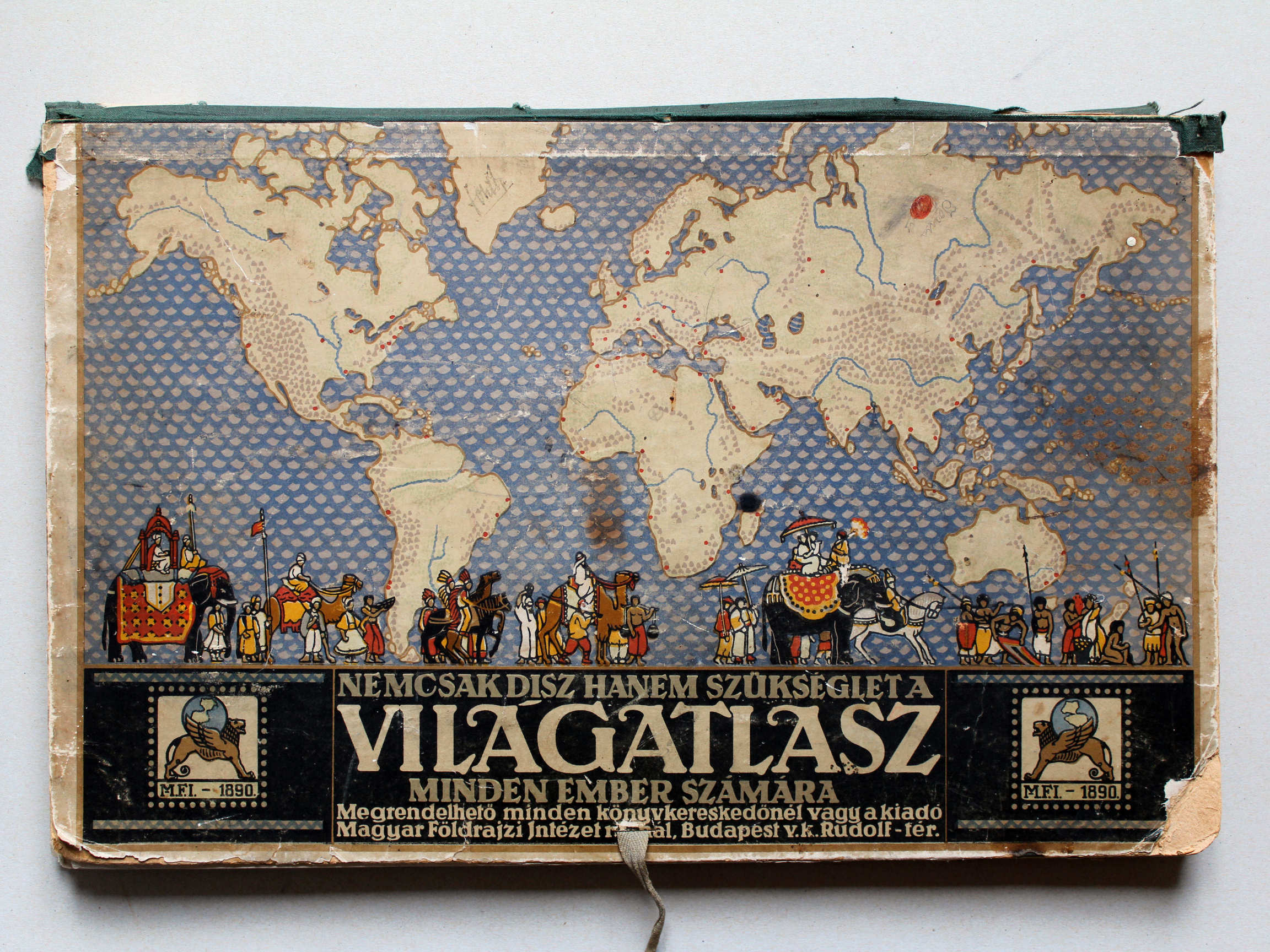
Dit exemplaar bestaat uit losse kaarten in een kartonnen map (30,5 × 47,5 cm, H × B) met linnen rug. Op de voorkant staat bovenaan een wereldkaart met daarbij personen uit verre landen. Daaronder zijn er, tussen symbolen van de uitgever M.F.I., een wervende tekst, de titel 'Világatlasz', de naam 'Magyar Földrajzi Intézet' van de uitgever en het adres. De kaarten zitten, voor zover ze twee bladzijden beslaan, gevouwen in de map.
Inhoud
De atlas is nooit voltooid, en dit exemplaar is dus ook onvolledig. Het bevat 37 kaarten, 35 op twee bladzijden en 2 op een enkele bladzijde. In totaal zijn er dus 72 van de geplande 130 bladzijden aanwezig.
De atlas begint met wereldkaarten, geografisch en thematisch, en een kaart van de Middellandse Zee. Daarna komen kaarten van Europa, van de Europese landen, en van de overige werelddelen. Bij elke 'afdeling' zijn geografische en enkele thematische kaarten gepland. Zie ook de inhoudsopgave.
Op de achterkanten – of buitenkanten – van de kaarten staan de naam van de kaart en de bijkaarten, en de namen van de medewerkers. Soms wordt ook vermeld de gebruikte kaartprojectie, een lijst van afkortingen, en/of een Hongaarse vertaling van de op de kaart gebruikte geografische termen.
De kaarten zijn vervaardigd in kleurenlithografie. De kleuring van de geografische kaarten is doorgaans staatkundig (randkleur met bies); de zeeën hebben een dieptekleuring met dieptelijnen, de bergen zijn aangegeven met bruine arcering. De thematische kaarten hebben een bij het thema passende kleuring.
In de bovenmarge staat in het midden de naam van de kaart; links staat meestal de naam van de atlas; zie de inhoudsopgave. In de benedenmarge staat in het midden de naam van de uitgever; links staan soms de namen van de medewerkers. De overige informatie staat binnen het kaartkader, zoals de schaal en de graveerdatum. Uit die datering blijkt dat de kaarten in de periode 1912-1914 vervaardigd zijn. De kaarten uit 1912 hebben als auteurs Teleki en Kogutowicz en de kaarten uit 1913 en 1914 Kogutowicz en Littke.
Vergelijking met Debes' Handatlas
Van de 37 kaarten in dit exemplaar zijn er 28 overgenomen uit de 4e druk van de Duitse Debes' Handatlas; één kaartblad (Nº 6-7) bestaat voor de helft uit kaarten uit de Duitse atlas. De overige 8 kaarten zijn speciaal voor deze atlas gemaakt. Dat zijn vooral thematische kaarten, en verder een kaart van de Middellandse Zee en een reliëfkaart van Hongarije.
De 'Duitse' kaarten zijn natuurlijk in het Hongaars vertaald. Daarbij worden naast de oorspronkelijke Duitse medewerkers ook steeds de Hongaarse genoemd. Een enkele keer is een bijkaartje dat bedoeld is om de schaal te vergelijken, vervangen door een bijkaartje van een deel van Hongarije, met hetzelfde doel.
Alle details zijn te vinden in de vergelijkende tabel. Er is ook een pagina met plaatjes van beide uitgaven ter vergelijking naast elkaar.
Bronnen:
Kogutowicz-Littke(-Debes): Világatlasz (1912-1914)
- Below is a description of the atlas in keywords. Related pages
- Pictures of the atlas
- Tables and lists to the atlas
- Comparison (pictures) with Debes' Handatlas
- Title description
- Title: Kogutowicz-Littke(-Debes): Világatlasz
Publisher: Magyar Földrajzi Intézet, Budapest
Year: 1912-1914 (on the maps) - Title page:
A Magyar Földrajzi Intézet Részvénytársaság világatlasza:
95 fő és 190 melléktérképpel, 130 térképlapon,
kb. 130.000 nevet tartalmazó névjegyzékkel,
terjedelmes és gazdagon illusztrált szöveges résszel
szerkesztik Kogutowicz Károly és Littke Aurél Translation:
The World Atlas of the Hungarian Geographical Institute Inc.:
with 95 main and 190 inset maps, on 130 map pages,
an index with approximately 130,000 names,
a voluminous and richly illustrated text part
edited by Károly Kogutowicz and Aurél Littke - Title page of the copy (656654317) in the Universitäts- und Forschungsbibliothek Erfurt/Gotha
- Title on portfolio cover:
Nemcsak disz hanem szükséglet a
Világatlasz minden ember számára
Megrendelhető minden könyvkereskedőnél vagy a kiadó
Magyar Földrajzi Intézet r.t. nál, Budapest v.k. Rudolf-tér. Translation:
Not only decorative but a necessity the
World Atlas for everyone
Available at every bookseller or the publisher
Hungarian Geographical Institute Inc., Budapest v.k. Rudolf Square. - r.t. = Részvénytársaság = joint stock company
- Title on portfolio cover:
- Title on portfolio cover: This is the Hungarian version, never completed, of the German Debes' Handatlas. This copy contains 72 out of the 130 planned map pages, so 58 pages are missing.
- The name of Ernst Debes, editor of the German atlas, is only mentioned on some maps, just as those of the other cooperators of the German atlas. Furthermore there are several Hungarian cooperators, among who Károly Kogutowicz and Aurél Littke are also mentioned on the title page – in Hungarian the family name precedes the first name.
- The title page given above was derived from the copy that originates from the library of Justus Perthes in Gotha. That copy is incomplete as well; it misses 26 maps, probably corresponding to 52 map pages.
- In the upper margin of the maps the title 'Teleki-Kogutowicz: Világatlasz' (on 11 maps from 1912) or 'Kogutowicz-Littke: Világatlasz' (on 24 maps from 1913-14) is mentioned. The last title, with the addition of the name of Debes, has been used for these pages. Apparently Pál Teleki has not contributed to the atlas after 1912.
- Károly Kogutowicz (1886-1948) was the son of Manó Kogutowicz (1851-1908), founder of the Magyar Földrajzi Intézet (Hungarian Geographical Institute) where this atlas was published.
- Title: Kogutowicz-Littke(-Debes): Világatlasz
- Binding
- This copy consists of separate maps in a cardboard portfolio (30.5 × 47.5 cm, H × W) with a cloth spine. On top of the front cover is a world map illustrated with people from faraway countries. Below, between symbols of the publisher M.F.I, are an advertising text, the title 'Világatlasz', the name 'Magyar Földrajzi Intézet' of the publisher and his address. The two page maps are folded.
- Contents
- The atlas was never completed; therefore this copy is incomplete as well. It contains 37 maps, 35 on two pages and 2 on a single page. In all, 72 out of the planned 130 pages are present.
- The atlas begins with several world maps, geographical and thematical ones, and a map of the Mediterranean Sea. Thereafter are maps of Europe, the European countries and the other continents. In each 'department' geographical and thematic maps were planned. See also the table of contents.
- On the verso – or exterior – of the maps are mentioned the name of the map and the inset maps, and the names of the cooperators. Sometimes are also mentioned the map projection used, a list of abbreviations, and/or a Hungarian translation of the geographical terms used on the map.
- The maps are produced in color lithography. The coloring of the maps is usually political (outline color with edging); the seas have depth color with depth contours; the mountains are indicated with brown hachuring. The thematic maps have a coloring appropriate to the theme.
- In the center of the top margin is the name of the map; on the left is usually the name of the atlas; see the table of contents. In the center of the lower margin is the publisher's name; sometimes on the left the names of the cooperators. All other information is inside the map frame, such as the scale and engraving date. From those dates it is obvious that the maps have been manufactured in the period 1912-1914. The maps form 1912 have Teleki and Kogutowicz as the authors, the maps from 1913 and 1914 Kogutowicz and Littke.
- In comparison with Debes' Handatlas
- This copy of the atlas contains 37 maps among which 28 derived from the 4th edition of the German Debes' Handatlas; half of one map sheet (Nº 6-7) contains maps from the German atlas. The other 8 maps have been produced specifically for this atlas, mostly thematical maps but also a map of the Mediterranean Sea and a relief map of Hungary.
- Of course the 'German' maps have been translated in Hungarian. Besides the German cooperators also the Hungarian cooperators are mentioned. In a few cases, an inset maps meant to compare scales has been replaced with an inset map of a Hungarian county, with the same purpose.
- All details can be found in the comparison table. There is also a page with pictures of both editions side by side for comparison purposes.
- Sources:
© M. Witkam, 2015
met dank aan / courtesy of: Rob Segers
![]()
![]()