Perthes Atlas portátil del mundo entero, 12e-17e druk (1925-1938)
See below for (a summary of) this text in English.
Hieronder staat de beschrijving van de Spaanse en Zuid-Amerikaanse uitgaven van de atlas. Daarbij horen ook de volgende pagina's.
- Plaatjes van de atlas
- Tabellen en lijsten bij de atlas
- Vergelijking (plaatjes) met de Duitse uitgave (1924-1937)
en ook
- Plaatjes van de 12e druk (Zuid-Amerikaanse uitgave, 1925)
- Plaatjes van de 17e druk (Spaanse uitgave, 1938)
Titelgegevens
Titel: Atlas portátil del mundo entero
Uitgever: Justus Perthes, Gotha
Jaar: 1925-1938 (12e-17e druk)
Titelpagina Zuid-Amerikaanse uitgave (12e druk, 1925):
Justus Perthes Atlas portátil del mundo entero
32 mapas grabados en cobre
Con noticias geográfico-estadísticas
Duodécima edición
Gotha: Justus Perthes 1925
Vertaling:
Justus Perthes' Zakatlas van de gehele wereld
32 kaarten in kopergravure
Met geografisch-statistische aantekeningen
Twaalfde druk
Gotha: Justus Perthes 1925
Titelpagina Spaanse uitgave (17e druk, 1938):
Justus Perthes Atlas portátil del mundo entero
28 mapas grabados en cobre
Con noticias geográfico-estadísticas
Décimo séptima edición
Gotha: Justus Perthes 1938
Vertaling:
Justus Perthes' Zakatlas van de gehele wereld
28 kaarten in kopergravure
Met geografisch-statistische aantekeningen
Zeventiende druk
Gotha: Justus Perthes 1938
-
Dit is de tweede (en laatste) reeks van Spaanstalige uitgaven van Justus Perthes' Taschen-Atlas. Deze uitgaven zijn gebaseerd op de Duitse Taschen-Atlas uit de periode 1924-1937 (60e-71e druk).
 Justus Perthes Atlas portátil del mundo entero
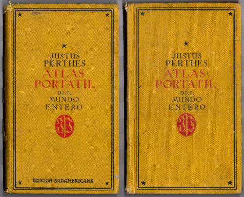
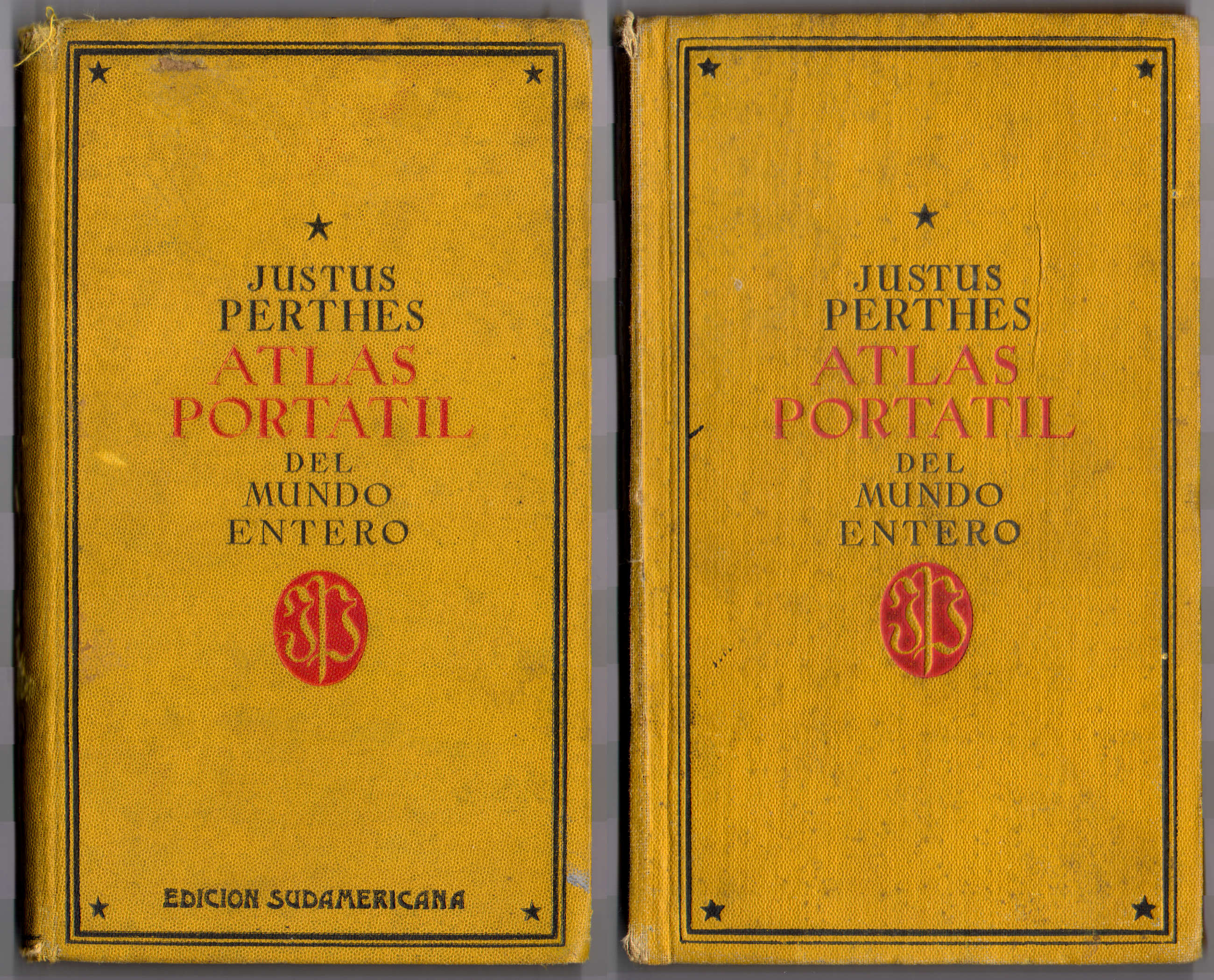
Voorkant banden (1925, 1938) - Kenmerkend voor de atlassen uit deze reeks is de sobere voorkant van de
band, met titel
- Justus Perthes Atlas portátil del mundo entero
- Het nummer van de druk van de Spaanstalige uitgaven is niet hetzelfde als het nummer van de Duitse uitgaven. Op de titelpagina wordt ook niet vermeld op welke druk van de Duitse uitgave de atlas is gebaseerd. Zie de lijst van uitgaven.
- Tot 1931 – misschien nog later – verscheen ook een Zuid-Amerikaanse uitgave met 4 extra kaarten van Argentinië en Paraguay.
- Naast deze Spaanstalige uitgaven is er ook één Zwitserse uitgave verschenen.
- Van deze uitgaven wordt, net als bij de Duitse uitgaven, geen auteur genoemd.
Band, schutbladen
De atlas heeft een band van geel 'calico' (gedrukt katoen) van 10,5 × 17,5 cm (B × H). Op de voorkant staat de titel "Justus Perthes Atlas portátil del mundo entero" met het logo van Justus Perthes in de vorm van het monogram JP. Bij de Zuid-Amerikaanse uitgaven staat onderaan "Edición sudamericana". De titel staat ook op de rug.
Op de schutbladen achterin wordt reclame gemaakt voor enkele andere cartografische uitgaven van Justus Perthes.
- De Spaanstalige uitgave van de 10e
druk van Stielers Hand-Atlas
- Stieler Gran Atlas Geográfico
- Twee grote kaarten van Spanje en Portugal samengesteld uit kaartbladen van
die atlas
- España y Portugal. Edición política
- España y Portugal. Economía – Comercio – Comunicaciones
- De Zakatlas van Spanje en Portugal
(verschenen in de periode 1929-1938)
- Atlas portátil de España y Portugal
- De Zakatlas van de Oudheid
- Atlas Antiquus. Atlas portátil de la Edad antigua
- De Almanach de Gotha
- De Spaanstalige uitgave van de Methodischer Wandatlas
(16 oro-hydrografische wandkaarten voor scholen)
- Sydow-Habenicht. Atlas mural metódico
De schutbladen zijn voorzien van een drukcode. Bijvoorbeeld
- 12e druk (1925): 109. II/27. 2000
- 15e druk (1931): 450. XI/30. 2500 en 450a. XI/30. 2500
- 17e druk (1938): 455. X/38. 3000
Deze code bestaat uit het druknummer (Druckauftragsnummer), de datum en het aantal gedrukte exemplaren van het schutblad – dat hoeft niet hetzelfde te zijn als het aantal exemplaren van de atlas.
Inhoud
De atlas bevat een titelpagina, 1 bladzijde voorwoord, 1 bladzijde inhoudsopgave en 38 bladzijden (in latere uitgaven 40) geografisch-statistische tekst. Tenslotte zijn er de 28 kaarten met afmetingen 19,5 × 17 cm, in kleur, enkelzijdig gedrukt op steviger papier dan dat van de tekstpagina's. De Zuid-Amerikaanse uitgave heeft nog 4 extra kaarten. Er is geen plaatsnamenregister.
De atlas begint met een wereldkaart en een kaart van Europa. Daarna zijn 4 kaarten van Spanje en Portugal (plattegronden van Lissabon en Madrid staan op de kaart van Marokko en Algerije), 8 kaarten van de andere landen in Europa, 3 van Azië, 2 van Afrika, 1 van Australië, 5 van Latijns-Amerika, 2 van Noord-Amerika en 1 van voormalige Spaanse koloniën (Cuba, Puerto Rico en de Filippijnen). De Zuid-Amerikaanse uitgave heeft daarna 4 kaarten van Argentinië en Paraguay (met een plattegrond van de hoofdstad Asunción). Zie voor de details de inhoudsopgave.
Vanwege het formaat van de kaarten is de schaal klein. Zo hebben de overzichtskaarten van de werelddelen de schaal 1:60.000.000 (Europa 1:30.000.000). De andere schalen zijn daar veelvouden van, zoals 1:7.500.000 (de meeste landen in Europa en Latijns-Amerika). De deelkaarten van het Iberisch Schiereiland zijn overgenomen uit Stielers Hand-Atlas en hebben een iets afwijkende schaal van 1:3.700.000 (dus niet 1:3.750.000). Zie voor de details de lijst van kaarten, bijkaarten en schaal. Ondanks die kleine schaal staan er veel gegevens op de kaarten zonder dat ze overvol zijn.
De kaarten zijn vervaardigd in kopergravure en lithografisch gedrukt. Bovenaan de kaart staan steeds de naam van het blad, de tekst "Atlas portátil" en het nummer van het blad. Onderaan staat de schaal, de tekst "Gotha: Justus Perthes" en een schaalstok. Gegevens over cartografen of graveurs ontbreken (behalve op de kaart van Paraguay, getekend door Bruno Domann).
Uitgaven
Deze reeks loopt van de 12e druk (1925) tot en met de 17e druk (1938). Er zijn in ieder geval Zuid-Amerikaanse uitgaven uit 1925 (12e druk), 1929 (14e druk) en 1931 (15e druk). Details staan in de lijst met uitgaven. De opzet van de atlas is in die periode van 14 jaar niet veranderd. Het aantal tekstpagina's is tussen 1925 en 1931 met twee toegenomen.
De kaarten werden wel regelmatig geactualiseerd. Dat is onder andere in de volgende gebieden te zien.
- Grenswijzigingen van de republieken in de Sovjet-Unie (kaarten 13, 15, 16)
- Veranderende grenzen in Afrika: Libië, Egypte, bezetting van Ethiopië (kaarten 15 en 18)
- Andere grenzen in Zuid-Amerika: Paraguay, Bolivia, Chili, Peru, Ecuador (kaarten 21, 23 en 25)
Zie ook de pagina met plaatjes van de uitgaven van 1925 en 1938.
Vergelijking met de Duitse en de voorafgaande Spaanse uitgaven
Vergeleken met de voorafgaande Spaanse uitgaven zijn er nauwelijks verschillen. De kaarten zijn natuurlijk geactualiseerd. De kleuren in de nieuwere uitgaven lijken iets feller.
In de Spaanstalige uitgaven (met 28/32 kaarten) staan 20 kaarten die ook in de Duitse uitgave (24 kaarten) voorkomen. Van de Duitse uitgave zijn de 3 deelkaarten van Duitsland en de kaart van Zweden, Noorwegen en Denemarken vervallen. De uitsnede van de overzichtskaart van Duitsland is verschoven waardoor ook Denemarken op die kaart past. Scandinavië is in de Spaanstalige uitgaven alleen nog te vinden op de kaart van Rusland, die daarvoor ook een stukje verschoven is.
Ook bij de bijkaarten is een en ander gewijzigd. De hoofdkaart van Spanje en Portugal heeft hier bijkaarten van Madeira en de Kaapverdische Eilanden. Op de kaart van Afrika zijn de bijkaarten van de voormalige Duitse koloniën vervangen door bijkaarten van de Canarische Eilanden, van de Congomonding en van Spaans Guinea. Op de kaart van Oceanië zijn de bijkaarten van Nieuw-Guinea, Samoa en Hawaï vervangen door kaarten van enkele vroeger Spaanse eilanden.
De 8 kaarten die niet in de Duitse uitgave voorkomen, zijn de 3 deelkaarten van het Iberisch Schiereiland, de kaart van Marokko en Algerije met plattegronden van Lissabon en Madrid, 3 deelkaarten van Latijns-Amerikaanse landen en de kaart van de voormalige Spaanse koloniën. Deze 8 kaarten zijn grotendeels ontleend aan Stielers Hand-Atlas. Dat geldt ook voor de 3 extra kaarten van Argentinië in de Zuid-Amerikaanse uitgave, maar niet voor de kaart van Paraguay.
Zie voor alle details de vergelijkende tabel. Er is ook een pagina met plaatjes van de Spaanse uitgave uit 1925 en de Duitse uit 1927 ter vergelijking naast elkaar.
Alle teksten en plaatsnamen zijn natuurlijk in het Spaans vertaald. De meeste namen zijn, ook zonder veel kennis van het Spaans, vrij eenvoudig te herkennen. Verrassend is wel de Spaanse naam Puerto Cruz voor Willemstad op Curaçao. In de uitgave van 1938 is die Spaanse naam weggelaten.
Geraadpleegde exemplaren
- Spaanse uitgaven: 1931, 1938
- Zuid-Amerikaanse uitgave: 1925
Perthes Atlas portátil del mundo entero, 12th-17th editions (1925-1938)
- Below is a description of the Spanish and South American versions of the
atlas. Related pages
- Pictures of the atlas
- Tables and lists to the atlas
- Comparison (pictures) with the German version (1924-1937)
- Title description
- Title: Atlas portátil del mundo entero
Publisher: Justus Perthes, Gotha
Year: 1925-1938 (12th-17th editions) - Title page South American version (12th edition, 1925):
Justus Perthes Atlas portátil del mundo entero
32 mapas grabados en cobre
Con noticias geográfico-estadísticas
Duodécima edición
Gotha: Justus Perthes 1925 Translation:
Justus Perthes Pocket Atlas of the entire World
32 maps in copper engraving
With geographical and statistical notes
Twelfth edition
Gotha: Justus Perthes 1925 - Title page Spanish version (17th edition, 1938):
Justus Perthes Atlas portátil del mundo entero
28 mapas grabados en cobre
Con noticias geográfico-estadísticas
Décimo séptima edición
Gotha: Justus Perthes 1938 Translation:
Justus Perthes Pocket Atlas of the entire World
28 maps in copper engraving
With geographical and statistical notes
Seventeenth edition
Gotha: Justus Perthes 1938 -
This is the second (and last) series of Spanish language versions of Justus Perthes' Taschen-Atlas. These versions are based on the German Taschen-Atlas from the 1924-1937 period (60th-71st editions).
Justus Perthes Atlas portátil del mundo entero
Front covers (1925, 1938) - The atlases of this series are characterized by their plain front
cover, with only the title
- Justus Perthes Atlas portátil del mundo entero
- The edition number of Spanish language versions is not the same as the number of the German versions. On the title page the number of the corresponding German edition is not mentioned. See also the list of editions.
- Until 1931 – maybe later – a South American version was published, with 4 additional maps of Argentina and Paraguay.
- Besides these Spanish language versions there is also one Swiss version.
- As in the German versions no author is mentioned for this atlas.
- Title: Atlas portátil del mundo entero
- Binding, endpapers
- The atlas has a yellow calico binding measuring 10.5 × 17.5 cm (W × H). On the front cover is the title "Justus Perthes Atlas portátil del mundo entero" with the Justus Perthes logo in the form of a monogram JP, The South American versions have the additional text "Edición sudamericana" in the lower margin. The title is also given on the spine.
- On the rear endpapers are advertisements for some other cartographic
works from Justus Perthes.
- The Spanish language version of the
10th edition of
Stielers Hand-Atlas
- Stieler Gran Atlas Geográfico
- Two large maps of Spain and Portugal composed of map sheets from
that atlas
- España y Portugal. Edición política
- España y Portugal. Economía – Comercio – Comunicaciones
- The Pocket Atlas of Spain and
Portugal (published in the 1929-1938 period)
- Atlas portátil de España y Portugal
- The Pocket Atlas of the Ancient
World
- Atlas Antiquus. Atlas portátil de la Edad antigua
- The Almanach de Gotha
- The Spanish language version of the Methodischer Wandatlas
(16 oro-hydrographical wall maps for schools)
- Sydow-Habenicht. Atlas mural metódico
- The Spanish language version of the
10th edition of
Stielers Hand-Atlas
- The endpapers are signed with a printing code. For example
- 12th edition (1925): 109. II/27. 2000
- 15th edition (1931): 450. XI/30. 2500 and 450a. XI/30. 2500
- 17th edition (1938): 455. X/38. 3000
- Contents
- The atlas has a title page, a preface and a table of contents of one page each, and 38 pages (40 in later editions) of geographical and statistical data. Thereafter are the 28 maps measuring 19.5 × 17 cm, in color, printed on one side only on heavier paper than the text pages. The South American version has 4 additional maps. There is no index.
- The atlas starts with a world map and a map of Europe. Thereafter are 4 maps of Spain and its colonies and Portugal (plans of Lisbon and Madrid are on the map of Morocco and Algeria), 8 maps of the other countries in Europe, 3 of Asia, 2 of Africa, 1 of Australia, 5 of Latin America, 2 of North America and 1 of the former Spanish colonies (Cuba, Puerto Rico and the Philippines). The South American version has a supplement with 4 maps of Argentina and Paraguay (with an inset of the capital Asunción). Details can be found in the table of contents.
- Because of the map size the scales are small. The general maps of the continents have a scale of 1:60,000,000 (Europe 1:30,000,000). The other scales are multiples of this, such as 1:7,500,000 (most countries in Europe and Latin America). The regional maps of Spain have been derived from Stielers Hand-Atlas and have a slightly different scale of 1:3,700,000 (not 1:3,750,000). Details can be found in the list of maps, inset maps and scale. In spite of the small scale the maps contain a lot of information without being overfilled.
- The maps have been produced in copper engraving and were printed lithographically. In the upper margin of the maps are the sheet name, the text "Atlas portátil" and the sheet number. In the lower margin is the scale, the text "Gotha: Justus Perthes" and a linear scale. No names of cartographers or engravers are mentioned (except for the map of Paraguay, drawn by Bruno Domann).
- Editions
- This series contains the 12th through 17th editions (1925-1938). The existence of South American versions from 1925 (12th edition), 1929 (14th edition) and 1931 (15th edition) is certain. Details can be found in the list of editions. The design of the atlas has not changed in those 14 years. The number of text pages has increased from 42 to 44.
- The maps have been updated regularly. This is – among others – obvious
from the maps of the following regions.
- Boundary changes of the republics of the Soviet union (sheets 13, 15, 16)
- Changed boundaries in Africa: Libya, Egypt, occupation of Ethiopia (sheets 15 and 18).
- Different boundaries in South America: Paraguay, Bolivia, Peru, Chile, Ecuador (sheets 21, 23 and 25)
- In comparison with the German and the preceding Spanish versions
- In comparison with the preceding Spanish editions the differences are negligible. Of course the maps have been updated. The colors in the new editions seem slightly brighter.
- The Spanish language versions (with 28/32 maps) contain 20 maps that can also be found in the German version (24 maps). The 3 regional maps of Germany and the map of Sweden, Norway and Denmark were omitted. The cut-out of the general map of Germany has shifted in order to fit Denmark on that map. In the Spanish language version Scandinavia can only be found on the map of Russia, also slightly shifted.
- There are also some changes in the inset maps. In the Spanish version of the atlas the general map of Spain and Portugal has insets of Madeira and the Cape Verde Islands. On the map of Africa the inset maps of German colonies have been replaced with insets of the Canary Islands, the mouth of the Congo River and Spanish Guinea. On the map of Oceania the inset maps of New Guinea, Samoa and Hawaii are replaced with insets of some formerly Spanish islands.
- The 8 maps not present in the German version are the 3 regional maps of the Iberian Peninsula, the map of the former Spanish colonies, the map of Morocco and Algeria with plans of Lisbon and Madrid, and 3 regional maps of Latin American countries. These 8 maps are largely derived from Stielers Hand-Atlas. This also applies to the 3 additional maps of Argentina in the South American version, but not to the map of Paraguay.
- Details can be found in the comparison table. There is also a page with pictures of the Spanish (1925) and German (1927) versions side by side for comparison purposes.
- All texts and place names have been translated into Spanish of course. Most names are rather easily recognizable, even without an extensive knowledge of Spanish. Surprisingly the Spanish name for Willemstad (Curaçao) is Puerto Cruz. This name was omitted in the 1938 edition.
Copies consulted
- Spanish versions: 1931, 1938
- South American version: 1925
© M. Witkam, 2011
![]()
![]()