Justus Perthes' Atlas antiquus, 1e-8e druk (1893-1909)
See below for (a summary of) this text in English.
Hieronder staat de beschrijving van de atlas. Daarbij horen ook de volgende pagina's
- Voorwoorden van de atlas
- Plaatjes van de atlas
- Tabellen en lijsten bij de atlas
en ook
- Plaatjes van de 3e druk van de atlas (Franse uitgave, 1895)
- Plaatjes van de 8e druk van de atlas (Duitse uitgave, ca. 1908)
Titelgegevens
Titel: Atlas antiquus
Uitgever: Justus Perthes, Gotha
Jaar: 1893-1909 (1e-8e druk)
Titelpagina Duitse uitgave (8e druk, ca. 1908):
Justus Perthes' Atlas antiquus.
Taschen-Atlas der Alten Welt von Dr. Alb. van Kampen.
24 Karten in Kupferstich mit Namenverzeichnis und einem Abrisse der alten Geschichte.
Achte Auflage
Gotha: Justus Perthes
Vertaling:
Justus Perthes' Atlas antiquus.
Zakatlas van de Oudheid door Dr. Alb. van Kampen.
24 kaarten in kopergravure met een register en een schets van de Oude Geschiedenis.
Achtste druk
Gotha: Justus Perthes
Titelpagina Franse uitgave (3e druk, 1895):
Justus Perthes, Atlas antiquus.
Atlas de poche du monde ancien par Dr. Alb. van Kampen.
24 cartes coloriées et gravées sur cuivre avec un index.
Troisième édition.
Gotha: Justus Perthes. 1895
Vertaling:
Justus Perthes, Atlas antiquus.
Zakatlas van de Oudheid door Dr. Alb. van Kampen.
24 gekleurde kaarten in kopergravure met een register.
Derde druk
Gotha: Justus Perthes. 1895
Titelpagina Engelse uitgave (6e druk, 1898):
Justus Perthes' Atlas antiquus.
Pocket Atlas of the Ancient World by Dr. Alb. van Kampen.
24 Copper-plate maps, colored; with an index.
Sixth edition.
Gotha: Justus Perthes.
Vertaling:
Justus Perthes' Atlas antiquus.
Zakatlas van de Oudheid door Dr. Alb. van Kampen.
24 gekleurde kaarten in kopergravure; met een register.
Zesde druk
Gotha: Justus Perthes.
-
Dit is de eerste reeks van zakatlassen van de Oudheid van Justus Perthes. Deze atlassen zijn onder verschillende titels tot 1961 uitgegeven. Zie ook het overzicht van alle zakatlassen van Justus Perthes.
 Perthes' Atlas antiquus
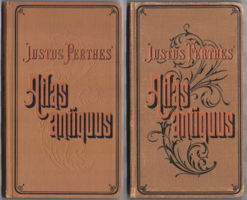
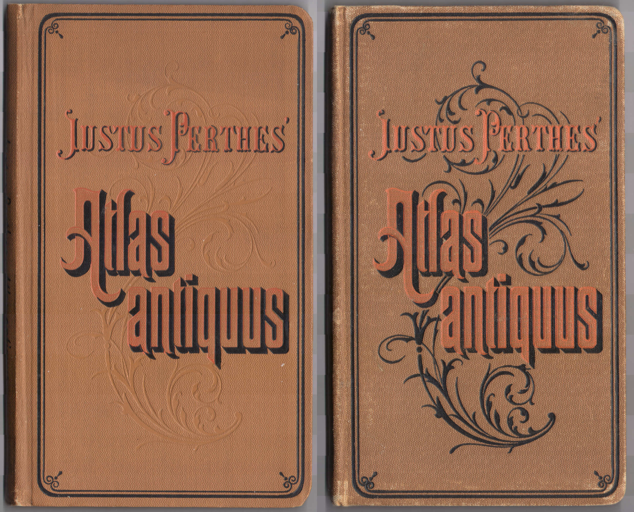
Voorkant banden 1895, ca. 1908 - Kenmerkend voor deze reeks is de decoratieve voorkant van de band, met de titel in sierletters op een achtergrond van een plantaardig motief.
- Deze atlas is verschenen in een Duitse uitgave met titelpagina, voorwoord
en (vanaf de 6e druk) schets van de Oude Geschiedenis in het Duits.
Daarnaast zijn er ook uitgaven in andere talen
- Atlas antiquus. Pocket Atlas of the Ancient World (Engels)
- Atlas antiquus. Atlas de poche du monde ancien (Frans)
- Atlas antiquus. Atlante tascabile del mondo antico (Italiaans)
- Atlas antiquus. Atlas portátil de Geografía antigua / Atlas portátil de la Edad antigua (Spaans)
- De auteur van deze atlas is Albert van Kampen (1842-1891). Na het overlijden van Albert van Kampen is de atlas voltooid door Max Schneider – zie ook het voorwoord. Alle kaarten zijn getekend door V. Geyer (Valentin Geyer, 1832-1909).
- De titel 'Atlas antiquus' wordt natuurlijk vaker gebruikt voor atlassen
van de Oudheid. Enkele andere uitgaven
- Karl von Spruner, Historisch-Geographischer Hand-Atlas,
Erste Abteilung: Atlas antiquus (1848-1906)
Justus Perthes, Gotha - Heinrich Kiepert, Atlas Antiquus (1859-1939)
Dietrich Reimer, Berlin
- Karl von Spruner, Historisch-Geographischer Hand-Atlas,
Erste Abteilung: Atlas antiquus (1848-1906)
Band
De atlas heeft een band van bruin 'calico' (gedrukt katoen) van 10,5 × 17,5 cm (B × H). Op de voorkant staat de titel "Justus Perthes' Atlas antiquus" in sierletters op een achtergrond van een plantaardig motief. De titel staat ook op de rug van de band. Vanaf 1906 – of eerder – staat op de achterkant van de band de tekst "Justus Perthes. Buchbinderei".
Vanaf 1895 – of eerder – wordt op de schutbladen reclame gemaakt voor verwante uitgaven van Justus Perthes, zoals
- de 9e druk van Stielers Hand-Atlas in verschillende varianten en met diverse banden
- de verschillende zakatlassen (in aantal toenemend van 4 tot 6) met het bewaardoosje voor de hele set
Zie ook de pagina met plaatjes.
Inhoud
De atlas bevat een titelpagina, 1 bladzijde inhoudsopgave, 1 of 2 bladzijden voorwoord en een register van 56 bladzijden. De Duitse uitgaven hebben vanaf de 6e druk (1898) een schets van de Oude Geschiedenis in 26 bladzijden in het Duits (zie het voorwoord bij de 6e druk). Die tekst ontbreekt in de uitgaven in andere talen. Verder zijn er de 24 kaarten met afmetingen 20 × 17 cm, in kleur, enkelzijdig gedrukt op steviger papier dan dat van de tekstpagina's.
De atlas begint met een wereldkaart en een afbeelding van de Peutinger-kaart. Daarna komen 19 kaarten, min of meer geordend van oost (Afrika, Azië, Griekenland) naar west (Romeinse Rijk). Tenslotte zijn er 3 kaartbladen met plattegronden (Athene, Rome, enkele kleinere steden). Zie ook de inhoudsopgave, de lijst van kaarten, bijkaarten en schaal en de vertaling van de Latijnse kaartnamen.
De kaarten zijn vervaardigd in kopergravure en lithografisch gedrukt. Tot ongeveer 1896 lijkt de kleur met de hand aangebracht, daarna in druk. Bovenaan de kaart staat steeds de titel "Atlas antiquus", de naam en het nummer van het blad. Onderaan staat de naam van de tekenaar V. Geyer en de tekst "Gotha: Justus Perthes".
Op veel kaarten staat rechtsonder de graveerdatum in de bij Perthes gebruikelijke codering: de maand en het laatste cijfer van het jaar in Romeinse cijfers. In de geraadpleegde exemplaren zijn die als volgt.
- 3e druk (Franse uitgave, 1895); kaarten 1-8: IX VI, kaarten 9-24: X VI
- 6e druk (Engelse uitgave, 1898); alle kaarten: IX VIII
- 8e druk (Duits, ca. 1908); de meeste kaarten: IX VIII, kaarten 12, 16, 17, 20, 23: niets
Dat zou betekenen dat de kaarten in de 3e druk dateren van september en oktober 1896, de kaarten in de 6e druk van september 1898 en die in de 8e druk van september 1908. De code IX VIII komt zowel in 1898 als in 1908 voor. Die kaarten zijn ook echt verschillend, wat het duidelijkst blijkt uit de kleuring van de bergen: in 1898 zwart en in 1908 lichtbruin.
Uitgaven
In de periode 1893-1909 zijn de 1e tot en met de 8e druk van de atlas verschenen; zie de lijst met uitgaven. De opzet van de atlas is in die periode niet veranderd. De kaarten hoefden natuurlijk ook niet geactualiseerd te worden. Er is wel overgegaan van handgekleurde kaarten naar kleurendruk (in ieder geval vanaf 1898). Ook het gebergte is in latere uitgaven (in ieder geval vanaf 1906) lichtbruin in plaats van zwart. Zie ook de pagina met plaatjes, en de aparte pagina's voor de uitgaven van 1895 en 1908.
Vergelijking met Orbis terrarum antiquus
De auteur Albert van Kampen van deze 'Atlas antiquus' was ook auteur van de schoolatlas voor de Oudheid 'Orbis terrarum antiquus' (1e druk 1884, 2e druk 1888). Het is dan ook niet verwonderlijk dat enkele kaarten uit deze atlas gebaseerd zijn op kaarten uit die schoolatlas, namelijk die van Egypte, Palestina, Griekenland en het Romeinse Rijk. Ook de meeste stadsplattegrondjes (kaart 24) zijn afkomstig uit de schoolatlas. Zie voor de details de vergelijkende tabel.
Geraadpleegde exemplaren
- Duitse uitgave: ca. 1908
- Franse uitgave: 1895
- Engelse uitgave: 1898
Justus Perthes' Atlas antiquus, 1st-8th editions (1893-1909)
- Below is a description of the atlas in keywords. Related pages
- and also
- Title description
- Title: Atlas antiquus
Publisher: Justus Perthes, Gotha
Year: 1893-1909 (1st-8th editions) - Title page German version (8th edition, ca. 1908):
Justus Perthes' Atlas antiquus.
Taschen-Atlas der Alten Welt von Dr. Alb. van Kampen.
24 Karten in Kupferstich mit Namenverzeichnis und einem Abrisse der alten Geschichte.
Achte Auflage
Gotha: Justus Perthes Translation:
Justus Perthes' Atlas antiquus.
Pocket Atlas of the Ancient World by Dr. Alb. van Kampen.
24 maps in copper engraving with an index and an outline of Ancient History.
Eighth edition
Gotha: Justus Perthes - Title page French version (3rd edition, 1895):
Justus Perthes, Atlas antiquus.
Atlas de poche du monde ancien par Dr. Alb. van Kampen.
24 cartes coloriées et gravées sur cuivre avec un index.
Troisième édition.
Gotha: Justus Perthes. 1895 Translation:
Justus Perthes, Atlas antiquus.
Pocket Atlas of the Ancient World by Dr. Alb. van Kampen.
24 colored maps in copper engraving with an index.
Third edition
Gotha: Justus Perthes. 1895 - Title page English version (6th edition, 1898):
Justus Perthes' Atlas antiquus.
Pocket Atlas of the Ancient World by Dr. Alb. van Kampen.
24 Copper-plate maps, colored; with an index.
Sixth edition.
Gotha: Justus Perthes. -
This is the first series of pocket size atlases of the Ancient World from Justus Perthes. These atlases have been published until 1961 under several different titles. See also the overview of all pocket atlases from Justus Perthes.
Perthes' Atlas antiquus
Front covers 1895, ca. 1908 - The atlases of this series are characterized by their decorative front cover, with ornamental lettering on a background of a vegetal design.
- The German version of this atlas has title page, preface and (from
1898) outline of Ancient History in German. Additionally versions in
other languages were published
- Atlas antiquus. Pocket Atlas of the Ancient World (English)
- Atlas antiquus. Atlas de poche du monde ancien (French)
- Atlas antiquus. Atlante tascabile del mondo antico (Italian)
- Atlas antiquus. Atlas portátil de Geografía antigua / Atlas portátil de la Edad antigua (Spanish)
- The author of this atlas is Albert van Kampen (1842-1891). After the decease of Albert van Kampen the atlas was completed by Max Schneider – see also the preface. All maps were drawn by V. Geyer (Valentin Geyer, 1832-1909).
- The title 'Atlas antiquus' is used more often for atlases of the
Ancient World. Some of them
- Karl von Spruner, Historisch-Geographischer Hand-Atlas,
Erste Abteilung: Atlas antiquus (1848-1906)
Justus Perthes, Gotha - Heinrich Kiepert, Atlas Antiquus (1859-1939)
Dietrich Reimer, Berlin
- Karl von Spruner, Historisch-Geographischer Hand-Atlas,
Erste Abteilung: Atlas antiquus (1848-1906)
- Title: Atlas antiquus
- Binding
- The atlas has a brown calico binding measuring 10.5 × 17.5 cm (W × H). On the front cover is the title "Justus Perthes' Atlas antiquus" in ornamental lettering on a background of a vegetal design. The title is also on the spine. From 1906 – or earlier – the back cover has the text "Justus Perthes. Buchbinderei".
- From 1895 – or earlier – the endpapers contain advertising for related
publications from Justus Perthes, such as
- the 9th edition of Stielers Hand-Atlas in several variants and with various bindings
- the various pocket atlases, increasing in number from 4 to 6, with the storage box for the entire set
- Contents
- The atlas has a title page, one page with the table of contents, a preface of 1 or 2 pages and an index of 56 pages. The German versions, starting with the 6th edition (1898), also have an outline of Ancient History in German (see the preface to the 6th edition). This text is missing from the versions in other languages. The map section contains 24 map sheets measuring 20 × 17 cm, in color, printed on one side only on heavier paper than the text pages.
- The atlas starts with a world map and an image of the Peutinger Map. Thereafter are 19 maps, ordered more or less from east (Africa, Asia, Greece) to west (Roman Empire). In the end are 3 map sheets with city plans (Athens, Rome, several minor cities). See also the table of contents, the list of maps, inset maps and scale and the translation of the Latin map names.
- The maps have been produced in copper engraving and were printed lithographically. Until around 1896 they seem hand colored; thereafter the color is printed. In the upper margin of the maps are the title "Atlas antiquus" and the sheet name and number. In the lower margin are the name of the draftsman V. Geyer and the text "Gotha: Justus Perthes".
- Most maps have an engraving date in the lower right, with the encoding
used by Perthes: month and last digit of the year in Roman numerals. In
the consulted copies they are as follows.
- 3rd edition (French version, 1895); maps 1-8: IX VI, maps 9-24: X VI
- 6th edition (English version, 1898); all maps: IX VIII
- 8th edition (German version, ca. 1908); most maps: IX VIII, maps 12, 16, 17, 20, 23: nothing
- This suggests that the maps in the 3rd edition date from September and October 1896, the maps in the 6th edition from September 1898 and those in the 8th edition from September 1908. The encoding IX VIII is present in both 1898 and 1908 editions. These maps are really different ones considering the mountain coloring: black in 1898 and light brown in 1908.
- Editions
- In the 1893-1909 period, the 1st through the 8th editions of the atlas were published; see the list of editions. The design of the atlas has not changed in those years. Of course the maps didn't need an update. There has been a transition from hand colored maps to color printing (in 1898 or earlier). In later editions (1906 or earlier) the mountains are printed in light brown instead of black. See also the pictures page, and the separate pages for the editions of 1895 and 1908.
- In comparison with Orbis terrarum antiquus
- The author Albert van Kampen of this 'Atlas antiquus' was also the author of the school atlas of the Ancient World 'Orbis terrarum antiquus' (1st edition 1884, 2nd edition 1888). So it doesn't come as a surprise that some of the maps in this atlas are based on those in that school atlas: Egypt, Palestine, Greece, the Roman Empire. Most city plans (sheet 24) also originate from the school atlas. Details can be found in the comparison table.
Copies consulted
- German version: ca. 1908
- French version: 1895
- English version: 1898
© M. Witkam, 2011
![]()
![]()