Tanner's Universal Atlas (1836-1846)
See below for (a summary of) this text in English.
Hieronder staat de beschrijving van de atlas. Daarbij horen ook de volgende pagina's
Titelgegevens
Titel: Tanner's Universal Atlas
Uitgever: H.S. Tanner, Carey & Hart, S.A. Mitchell
Jaar: 1836, 1839, 1843, 1844, 1845, 1846
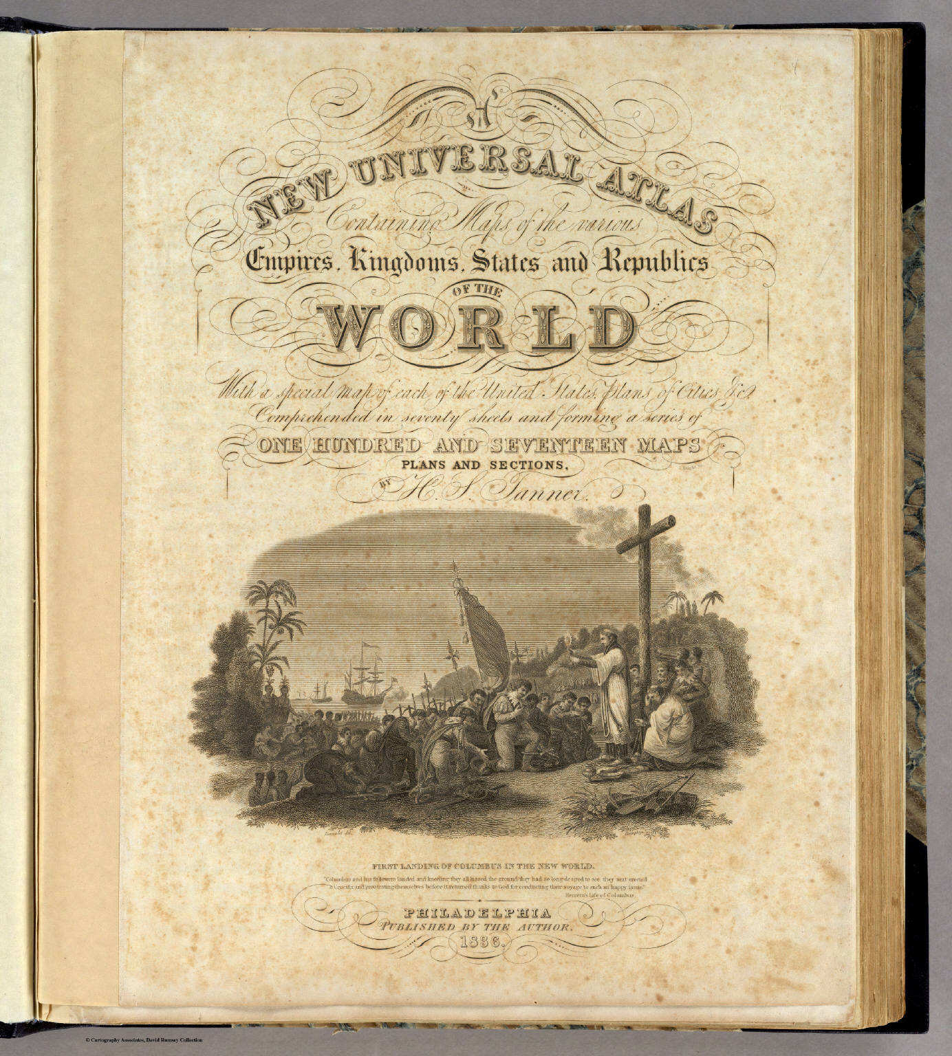
Titelpagina (1836):
A New Universal Atlas
Containing Maps of the various Empires, Kingdoms, States and Republics
Of The World.
With a special map of each of the United States, Plans of Cities &c.
Comprehended in seventy sheets and forming a series of
One Hundred And Seventeen Maps, Plans And Sections,
by H.S. Tanner.
Philadelphia, Published By The Author. 1836.
Vertaling:
Een nieuwe wereldomvattende atlas
Met kaarten van de verschillende keizerrijken, koninkrijken, staten en republieken van de wereld.
Met een afzonderlijke kaart van elk van de Verenigde Staten, plattegronden van steden enz.
Zeventig bladen omvattend en een reeks vormend van
honderdzeventien kaarten, plattegronden en profielen,
door H.S. Tanner
Philadelphia, uitgegeven door de auteur. 1836.
- Het hier beschreven exemplaar maakt deel uit van David Rumsey Map Collection.
- Beeldmateriaal uit David Rumsey Map Collection valt onder een Creative Commons License.
-
Van deze atlas zijn in de Library of
Congress Online Catalog (Verenigde Staten) de volgende uitgaven te vinden.
- Philadelphia: Published by the author, 1836.
- Philadelphia: Published by the author, 1839.
- Philadelphia, Published by Carey & Hart, 1842, [1843]
- Philadelphia: Carey & Hart, 1844.
- Philadelphia: Carey & Hart, 1845.
- Philadelphia: Published by S. Augustus Mitchell, 1846.
- Vanaf 1846 is de atlas uitgegeven door S.A. Mitchell als Mitchell's Universal Atlas. De naam Tanner wordt daarbij niet meer vermeld.
- De kaarten van de atlas waren oorspronkelijk kopergravures. Vanaf de uitgave van 1845 werden ze lithografisch gedrukt (steendruk).
- Veel kaarten van Amerika uit deze atlas zijn overgenomen in Meyer's Großer Hand-Atlas (1843-1860) van het Bibliographische Institut (Duitsland). Daarom is hij hier ook opgenomen.
Inhoud
De atlas bevat een titelpagina, een bladzijde met de inhoudsopgave, een bladzijde met een register van namen van landen, deelstaten en steden (en van de in de atlas opgenomen tabellen), en een bladzijde met een voorwoord van de auteur. Daarna komen de 69 kaartbladen van de atlas.
Het accent ligt met 38 van de 69 kaartbladen op Amerika, met de nadruk op de Verenigde Staten: 25 kaarten en 3 plattegronden. Voor Europa zijn er 19 kaartbladen. De andere werelddelen zijn in (veel) minder detail gegeven; Azië: 6 kaarten, Afrika: 2 kaarten, Oceanië: 1 kaart, Palestina: 1 kaart, en nog een afbeelding van de hoogste bergen en langste rivieren. Australië is alleen getekend op een bijkaart bij de overzichtskaart van Azië. Zie ook de lijst van kaarten, bijkaarten en schaal
De kaarten van dit exemplaar zijn vervaardigd in kopergravure. De administratieve indeling van de landen en staten is aangegeven met een, met de hand aangebrachte, vlakkleur. Ruim de helft van de kaarten heeft een jaartal (1833-1836); zie de lijst van kaarten en datering. Op ongeveer een derde deel van de kaarten wordt de auteur Tanner genoemd, in het bijzonder op de kaarten van de Verenigde Staten. Op ruim twee derde deel van de kaarten wordt de graveur vermeld. De meest voorkomende namen zijn Brose, Dawson, Knight en Warr. Zie voor de details de lijst van cartografen en graveurs.
Tanner's Universal Atlas (1836-1846)
- Below is a description of the atlas in keywords. Related pages
- Title description
- Title: Tanner's Universal Atlas
Publisher: H.S. Tanner, Carey & Hart, S.A. Mitchell
Year: 1836, 1839, 1843, 1844, 1845, 1846 - Title page (1836):
A New Universal Atlas
Containing Maps of the various Empires, Kingdoms, States and Republics Of The World.
With a special map of each of the United States, Plans of Cities &c.
Comprehended in seventy sheets and forming a series of
One Hundred And Seventeen Maps, Plans And Sections,
by H.S. Tanner.
Philadelphia, Published By The Author. 1836. - This copy of the atlas is part of the David Rumsey Map Collection.
- Images from the David Rumsey Map Collection are licensed under a Creative Commons License.
- The following editions of this atlas can be
found in the Library of Congress
Online Catalog.
- Philadelphia: Published by the author, 1836.
- Philadelphia: Published by the author, 1839.
- Philadelphia, Published by Carey & Hart, 1842, [1843]
- Philadelphia: Carey & Hart, 1844.
- Philadelphia: Carey & Hart, 1845.
- Philadelphia: Published by S. Augustus Mitchell, 1846.
- From 1846 the atlas was published by S.A. Mitchell under the name Mitchell's Universal Atlas. The name of Tanner is not mentioned any more.
- Originally the maps of the atlas were copper engravings. From the 1845 edition they were printed lithographically.
- Many of the maps of the Americas from this atlas have been adopted in Meyer's Großer Hand-Atlas (1843-1860) by the Bibliographische Institut (Germany). Therefore the atlas has been described in these pages.
- Title: Tanner's Universal Atlas
- Contents
- The atlas has a title page, a page with the table of contents, an index page with the names of countries, subdivisions and cities (and the tables in the atlas), a page with an author's notice and the 69 map sheets of the atlas.
- The emphasis is on the Americas, with 38 out of 69 map sheets, and especially on the United States: 25 maps and 3 city plans. There are 19 maps of Europe. The other continents are given in considerably less detail; Asia: 6 sheets, Africa: 2 sheets, Oceania: 1 sheet, Palestine: 1 sheet, and a sheet of the highest mountains and longest rivers of the world. Australia is only given as an inset map to the map of Asia. See also the list of maps, inset maps and scale.
- The maps of this copy have been produced in copper engraving. The subdivision of countries and states has been indicated by area color (hand coloring). On more than half of the maps a year is indicated (1833-1836); see the list of maps and date. On about one third of the maps the author Tanner is mentioned, especially on the maps of the United States. Two thirds of the maps bear the name of the engraver. The most frequent names are Brose, Dawson, Knight and Warr. Details can be found in the list of cartographers and engravers.
- Beeldmateriaal uit David Rumsey Map Collection valt onder een Creative Commons License.
- Images from the David Rumsey Map Collection are licensed under a Creative Commons License.
HTML © M. Witkam, 2009
![]()
![]()