Mitchell's Universal Atlas (1846-1859)
See below for (a summary of) this text in English.
Hieronder staat de beschrijving van de atlas. Daarbij horen ook de volgende pagina's
- Plaatjes van de atlas
- Tabellen en lijsten bij de atlas
- Vergelijking van Mitchell's Universal Atlas (1846) en Tanner's Universal Atlas (1836)
Titelgegevens
Titel: Mitchell's Universal Atlas
Uitgever: S.A. Mitchell; Thomas, Cowperthwait; Cowperthwait, Desilver
& Butler; C. Desilver; Cushings & Bailey
Jaar: 1846, 1847, 1848, 1849, 1850, 1851, 1852, 1853, 1855, 1856, 1857,
1859
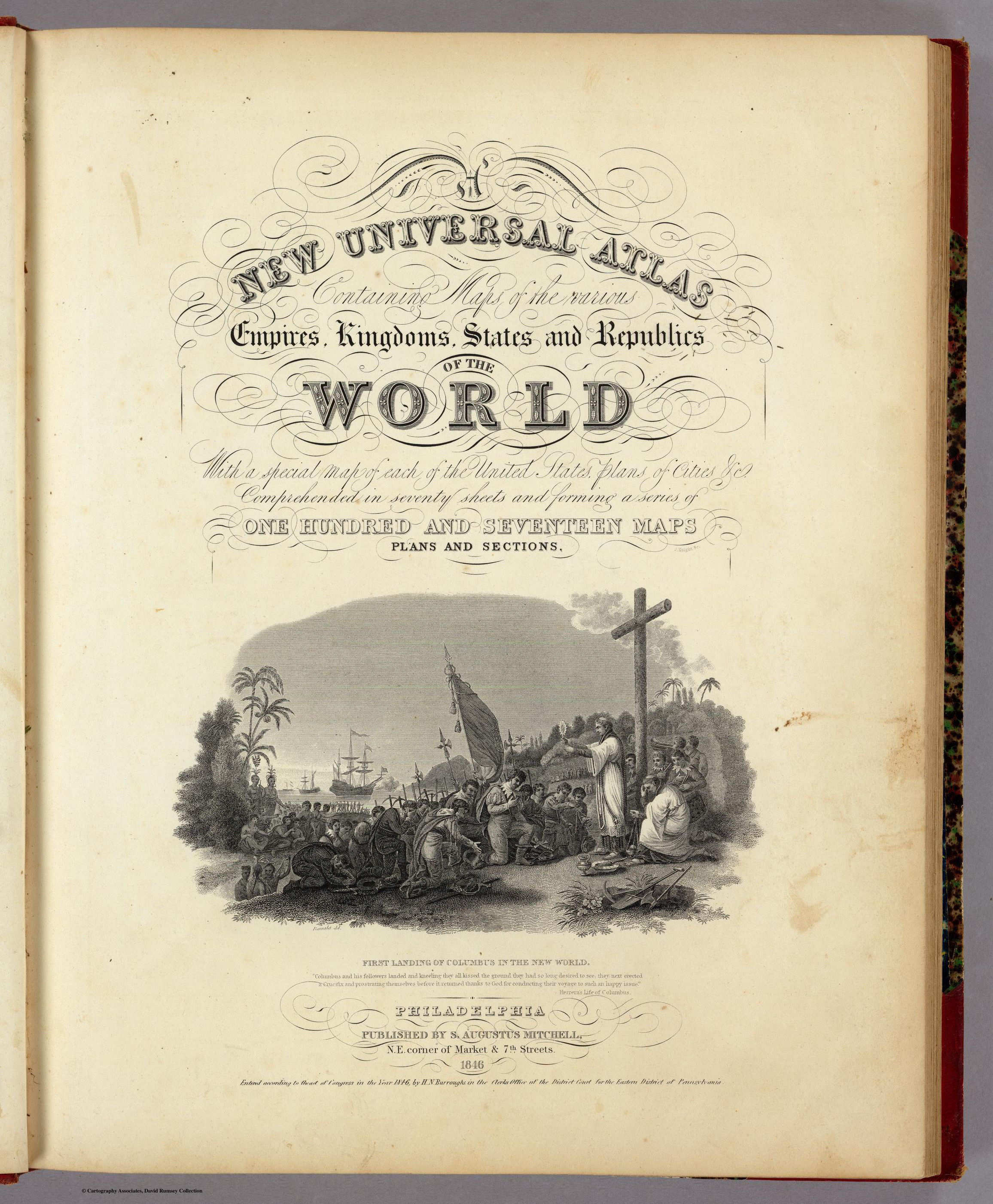
Titelpagina (1846):
A New Universal Atlas
Containing Maps of the various Empires, Kingdoms, States and Republics
Of The World
With a special map of each of the United States, Plans of Cities &c.
Comprehended in seventy sheets and forming a series of
One Hundred And Seventeen Maps, Plans And Sections
Philadelphia, Published By S. Augustus Mitchell, N.E. corner of Market
& 7th Streets. 1846
Vertaling:
Een nieuwe wereldomvattende atlas
Met kaarten van de verschillende keizerrijken, koninkrijken, staten en
republieken van de wereld.
Met een afzonderlijke kaart van elk van de Verenigde Staten, plattegronden
van steden enz.
Zeventig bladen omvattend en een reeks vormend van
honderdzeventien kaarten, plattegronden en profielen,
Philadelphia, uitgegeven door S. Augustus Mitchell, N.E. corner of Market
& 7th Streets. 1846
- Het hier beschreven exemplaar maakt deel uit van David Rumsey Map Collection.
- Beeldmateriaal uit David Rumsey Map Collection valt onder een Creative Commons License.
- In tegenstelling tot het op de titelpagina genoemde aantal van 70 kaartbladen bevat deze uitgave (1846) er 72.
- Deze atlas is de opvolger van Tanner's Universal Atlas (1836-1846). De verwijzingen naar Tanner op de kaarten zijn bijna allemaal verdwenen. Op de titelpagina wordt hij niet meer vermeld.
- Van deze atlas zijn in de Library of
Congress Online Catalog (Verenigde Staten) de volgende uitgaven te
vinden.
- Philadelphia: S. A. Mitchell, 1846.
- Philadelphia: S. A. Mitchell, 1847.
- Philadelphia: S. A. Mitchell, 1848.
- Philadelphia: Published by S. Augustus Mitchell, 1849.
- Philadelphia: Thomas, Cowperthwait, 1850.
- Philadelphia: Thomas, Cowperthwait, 1851.
- Philadelphia: Thomas, Cowperthwait, 1852.
- Philadelphia: Thomas, Cowperthwait, 1853.
- Philadelphia: Cowperthwait, Desilver & Butler, 1855.
- Philadelphia: C. Desilver, 1856.
- Philadelphia: C. Desilver, 1857.
- Baltimore: Cushings & Bailey, 1859.
- Opvolger van deze atlas is Mitchell's New General Atlas (vanaf 1860).
- Veel kaarten van Amerika uit deze atlas zijn overgenomen in Meyer's Großer Hand-Atlas (1843-1860) van het Bibliographische Institut (Duitsland). Daarom is hij hier ook opgenomen.
Inhoud
De atlas bevat een titelpagina, een bladzijde met de inhoudsopgave, en 72 kaartbladen. Het accent ligt met 41 kaarten op Amerika, met de nadruk op de Verenigde Staten: 28 kaarten en 3 plattegronden. Voor Europa zijn er 19 kaartbladen. De andere werelddelen zijn in (veel) minder detail gegeven; Azië: 6 kaarten, Afrika: 2 kaarten, Oceanië: 1 kaart, Palestina: 1 kaart, en nog een afbeelding van de hoogste bergen en langste rivieren. Australië is alleen getekend op een bijkaart bij de overzichtskaart van Azië. Zie ook de lijst van kaarten, bijkaarten en schaal
De kaarten van dit exemplaar zijn vervaardigd in lithografie (steendruk). De administratieve indeling van de landen en staten is aangegeven met een, met de hand aangebrachte, vlakkleur. De helft van de kaarten heeft het jaartal 1846; de kaart van Texas is gedateerd 1845; zie de lijst van kaarten en datering. Op drie van de kaarten (12, 36, 68) wordt H.S. Tanner nog als auteur genoemd. De naam van de graveur, J. Knight (titelpagina) of F. Humphrys (72), wordt genoemd op twee van de kaarten.
Vergelijking met Tanner's Universal Atlas
De kaarten uit deze atlas komen bijna allemaal ook voor in Tanner's Universal Atlas (1836); ze staan allen niet in precies dezelfde volgorde. De stadsplattegronden van New York, Philadelphia en Washington staan bij Tanner achter in de atlas en bij Mitchell tussen de andere kaarten van de Verenigde Staten. Het totale aantal kaarten is met drie toegenomen. Het gaat daarbij om kaarten van de nieuwe staten Wisconsin (in 1848 bij de Verenigde Staten), Iowa (1846) en Texas (1845). Zie voor de details
- een vergelijking van Mitchell's Atlas met Tanner's Atlas
- een vergelijking van Tanner's Atlas met Mitchell's Atlas
- de pagina met kaarten van de Mitchell (1846) en de Tanner (1836) naast elkaar.
Mitchell's Universal Atlas (1846-1859)
- Below is a description of the atlas in keywords. Related pages
- Pictures of the atlas
- Tables and lists to the atlas
- Comparison of Mitchell's Universal Atlas (1846) and Tanner's Universal Atlas (1836)
- Title description
- Title: Mitchell's Universal Atlas
Publisher: S.A. Mitchell; Thomas, Cowperthwait; Cowperthwait, Desilver & Butler; C. Desilver; Cushings & Bailey
Year: 1846, 1847, 1848, 1849, 1850, 1851, 1852, 1853, 1855, 1856, 1857, 1859 - Title page (1846):
A New Universal Atlas
Containing Maps of the various Empires, Kingdoms, States and Republics Of The World
With a special map of each of the United States, Plans of Cities &c.
Comprehended in seventy sheets and forming a series of
One Hundred And Seventeen Maps, Plans And Sections
Philadelphia, Published By S. Augustus Mitchell, N.E. corner of Market & 7th Streets. 1846 - This copy of the atlas is part of the David Rumsey Map Collection.
- Images from the David Rumsey Map Collection are licensed under a Creative Commons License.
- The title page calls for 70 map sheets, but this edition (1846) has 72.
- This atlas is the successor to Tanner's Universal Atlas (1836-1846). References to Tanner have almost disappeared. His name is not mentioned on the title page any more.
- The following editions of this atlas can be
found in the Library of Congress
Online Catalog.
- Philadelphia: S. A. Mitchell, 1846.
- Philadelphia: S. A. Mitchell, 1847.
- Philadelphia: S. A. Mitchell, 1848.
- Philadelphia: Published by S. Augustus Mitchell, 1849.
- Philadelphia: Thomas, Cowperthwait, 1850.
- Philadelphia: Thomas, Cowperthwait, 1851.
- Philadelphia: Thomas, Cowperthwait, 1852.
- Philadelphia: Thomas, Cowperthwait, 1853.
- Philadelphia: Cowperthwait, Desilver & Butler, 1855.
- Philadelphia: C. Desilver, 1856.
- Philadelphia: C. Desilver, 1857.
- Baltimore: Cushings & Bailey, 1859.
- Successor to this atlas is Mitchell's New General Atlas (from 1860).
- Many of the maps of the Americas from this atlas have been adopted in Meyer's Großer Hand-Atlas (1843-1860) from the Bibliographische Institut (Germany). Therefore the atlas has been described in these pages.
- Title: Mitchell's Universal Atlas
- Contents
- The atlas has a title page, a page with the table of contents and 72 map sheets. The emphasis is on the Americas, with 41 map sheets, and especially on the United States: 28 maps and 3 city plans. There are 19 maps of Europe. The other continents are given in considerably less detail; Asia: 6 sheets, Africa: 2 sheets, Oceania: 1 sheet, Palestine: 1 sheet, and a sheet of the highest mountains and longest rivers of the world. Australia is only given as an inset map to the map of Asia. See also the list of maps, inset maps and scale.
- The maps have been produced in lithography. The subdivision of countries and states has been indicated by area color (hand coloring). On half of the maps the year 1846 is indicated; the Texas mas has the year 1845; see the list of maps and date. On three of the maps (12, 36, 68) the name of H.S. Tanner is still mentioned. The name of the engraver, J. Knight (title page) or F. Humphrys (72), is given on two of the maps.
- In comparison with Tanner's Universal Atlas
- Almost all of the maps in this atlas are also present in Tanner's Universal Atlas (1836), though not in exactly the same order. In Tanner's atlas the city plans of New York, Philadelphia and Washington are located in the back; in Mitchell’s atlas they are given in between the other United States maps. The total number of sheets has increased with 3, for the new states of Wisconsin (one of the United states in 1848), Iowa (1846) and Texas (1845). Details can be found in the following tables and pages.
- Beeldmateriaal uit David Rumsey Map Collection valt onder een Creative Commons License.
- Images from the David Rumsey Map Collection are licensed under a Creative Commons License.
HTML © M. Witkam, 2009
![]()
![]()