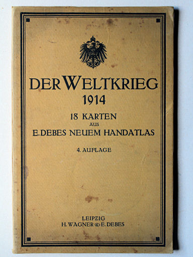
Der Weltkrieg 1914. 18 Karten aus Debes Neuem Handatlas
See below for (a summary of) this text in English.
Hieronder staat de beschrijving van de atlas. Daarbij horen ook de volgende pagina's
Titelgegevens
Titel: Der Weltkrieg 1914
Uitgever: Wagner & Debes, Leipzig
Jaar: 1914
Titel (voorkant band):
Der Weltkrieg 1914
18 Karten aus Debes Neuem Handatlas 4. Auflage
Leipzig H. Wagner & E. Debes
Vertaling:
De Wereldoorlog 1914
18 kaarten uit Debes' Neuer Handatlas 4e druk
Leipzig H. Wagner & E. Debes
- Dit is een verzameling van 18 kaartbladen (20 kaarten) uit Debes' Neuer Handatlas, 4e druk, uitgave 1914. Deze kaarten zijn bedoeld om het verloop van de (Eerste) Wereldoorlog te kunnen volgen. Het zijn ongewijzigde kaarten uit de uitgave van 1914 van Debes' Handatlas. Ze zijn dus niet geactualiseerd, ook niet in de latere uitgaven (1915, 1916) van Der Weltkrieg.
Band
De atlas heeft een band van buigzaam karton beplakt met geel linnen; de afmetingen zijn 44 × 29 cm (H × B). Op de voorkant staan de titel van de atlas en de Duitse keizerlijke adelaar binnen een rechthoekig kader. De achterkant en de rug bevatten geen tekst of ornamenten. Op het schutblad voorin staat de inhoudsopgave.
Inhoud
De atlas bevat 20 kaarten op 18 kaartbladen. Er is geen titelpagina en geen register. De kaarten geven de gebieden weer waar de wereldoorlog zich op dat moment afspeelde: Duitsland, Oostenrijk-Hongarije, Rusland, Balkanschiereiland, Azië, Afrika en Australië. De kaarten zijn meestal linksonder gedateerd. Daaruit blijkt dat ze gemaakt zijn in de jaren 1911-1913. De data zijn dezelfde als die van de overeenkomstige kaarten in Debes' Handatlas (uitgave 1914).
Op de achterkanten – of buitenkanten – van de kaarten staan de naam van de kaart en de bijkaarten, de schaal en de namen van de cartografen. Bijna altijd wordt ook de gebruikte kaartprojectie vermeld.
De kaarten zijn vervaardigd in kleurenlithografie. De kleuring van de geografische kaarten is doorgaans staatkundig (randkleur met bies); de zeeën hebben een dieptekleuring met dieptelijnen, de bergen zijn aangegeven met bruine arcering.
In de bovenmarge staat in het midden de naam van de kaart; links staat meestal de naam van de oorspronkelijke atlas 'E. Debes' Neuer Handatlas', rechts het bladnummer. In de benedenmarge staat in het midden de naam van de uitgever; links staan vaak de namen van de cartografen en rechts die van de graveurs. De overige informatie staat binnen het kaartkader, zoals de schaal en de graveerdatum.
Der Weltkrieg 1914. 18 Karten aus Debes Neuem Handatlas
- Below is a description of the atlas in keywords. Related pages
- Title description
- Title: Der Weltkrieg 1914
Publisher: Wagner & Debes, Leipzig
Year: 1914 - Title (front cover):
Der Weltkrieg 1914
18 Karten aus Debes Neuem Handatlas 4. Auflage
Leipzig H. Wagner & E. Debes Translation:
The World War 1914
18 maps from Debes' Neuer Handatlas 4th edition
Leipzig H. Wagner & E. Debes - This is a set of 18 map sheets (20 maps) from Debes' Neuer Handatlas, 4th edition, 1914 printing. The maps are meant to be able to follow the events of the (First) World War. The maps have been derived unaltered from the 1914 printing of Debes' Handatlas. In other words, they have not been updated, not even in the subsequent editions (1915, 1916) of Der Weltkrieg.
- Title: Der Weltkrieg 1914
- Binding
- The atlas has a binding of flexible cardboard pasted with yellow cloth; its dimensions are 44 × 29 cm (H × W). On the front cover are the title and the German imperial eagle inside a rectangular frame. The back cover and spine contain no text or ornaments. On the front endpaper is printed the table of contents
- Contents
- The atlas contains 20 maps on 18 sheets. There is no title page or index. The maps depict the regions where the World War was going on in the year 1914: Germany, Austria-Hungary, Russia, Balkan Peninsula, Asia, Africa and Australia. On the lower left of the maps there is usually a date. These dates turn out that the maps were made in the period 1911-1913. The dates are the same as those of the corresponding maps in Debes' Handatlas (1914 printing).
- On the verso – or exterior – of the maps are mentioned the name of the map and the inset maps, the scale and the names of the cartographers. Almost always is mentioned the map projection used.
- The maps are produced in color lithography. The coloring of the maps is usually political (outline color with edging); the seas have depth color with depth contours; the mountains are indicated with brown hachuring.
- In the center of the top margin is the name of the map; on the left is usually the name of the original atlas 'E. Debes' Neuer Handatlas', on the right sheet number. In the center of the lower margin is the publisher's name; on the left are often the names of the cartographers, on the right those of the engravers. All other information is inside the map frame, such as the scale and engraving date.
© M. Witkam, 2015


