Meyer's Universal-Atlas (1830-1840)
See below for (a summary of) this text in English.
Hieronder staat de beschrijving van de atlas. Daarbij horen ook de volgende pagina's
Titelgegevens
Titel: Meyer's Universal-Atlas
Uitgever: Bibliographisches Institut
Jaar: 1830-1840
Titelpagina:
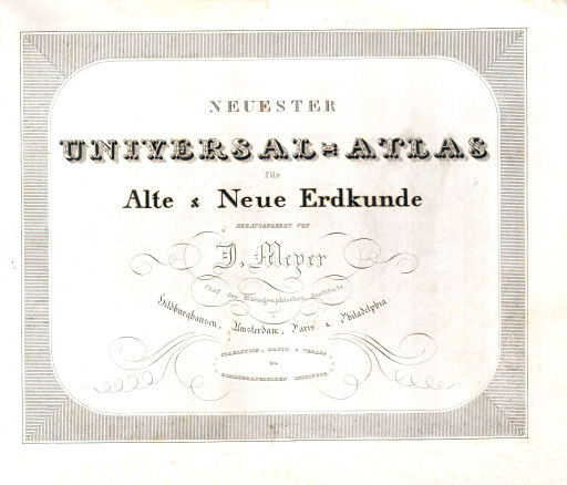
Neuester Universal-Atlas für Alte & Neue Erdkunde
Herausgegeben von J. Meyer
Chef des Bibliographischen Instituts in Hildburghausen, Amsterdam,
Paris & Philadelphia.
Stahlstich, Druck & Verlag des Bibliographischen Instituts.
Vertaling:
Nieuwste algemene atlas voor historische en hedendaagse geografie
Onder redactie van J. Meyer
Hoofd van het Bibliographische Instituut in Hildburghausen, Amsterdam,
Parijs & Philadelphia.
Staalgravure, druk en uitgave van het Bibliographische Instituut
- Dit is de eerste atlas van het Bibliographische Institut. Bijna 40 kaarten werden ook gebruikt in de Schul-Atlas (1830-1838). Een uitgave met kaarten in kleiner formaat (18 × 12 cm), gedeeltelijk gebaseerd op deze atlas, verscheen onder de titel Pfennig-Atlas (1834-1841). De opvolgers van deze atlas, met ongeveer hetzelfde formaat, zijn de Zeitungs-Atlas (1848-1857) en de Groschen-Atlas (1853-1869).
- De kaarten uit al deze uitgaven, behalve die uit de Pfennig-Atlas, zijn ook gebruikt in de encyclopedieën van het Bibliographische Institut (Meyers Lexikon). Vanaf 1892 zijn, juist andersom, de kaarten uit de encyclopedie gebundeld tot atlas.
- Naast deze betrekkelijk kleine atlassen verschenen in de periode 1843-1877
ook twee veel grotere atlassen, zowel in afmetingen als in aantal kaarten.
- Meyer's Großer Hand-Atlas (1843-1860, 170 kaarten en plattegronden)
- Meyer's Hand-Atlas (1862-1877, 100 kaarten)
- De hoofdvestiging van het Bibliographische Institut was in Hildburghausen (Thüringen). Uit de titel van deze atlas en de teksten op de kaarten blijkt dat er nevenvestigingen waren in Amsterdam, Parijs, New York en Philadelphia. De kaarten werden (ook) gegraveerd in Schweinfurt (Beieren), ongeveer 60 kilometer ten zuidwesten van Hildburghausen.
Band
De kaarten van de atlas verschenen van 1830 tot 1840 in afleveringen. Ze werden vaak ongevouwen ingebonden. In mijn exemplaar hebben de ongevouwen kaarten de afmetingen 32 × 26,5 cm (B × H). Er zijn ook exemplaren bekend met gevouwen kaarten.
Inhoud
De atlas bevat titelpagina, inhoudsopgave en 90 kaartbladen – dus niet 89 zoals in de inhoudsopgave staat, want er zijn twee kaarten nr. 8 (Italia superior). Zie ook de lijst van kaarten in volgorde van de inhoudsopgave. Verder zijn er 12 bladen met tabellen die allerlei gegevens over de verschillende landen bevatten. Ze zijn opgesteld door A. Ravenstein in Frankfurt am Main. De tabellen zijn, in mijn exemplaar, ingebonden in de buurt van de kaarten van het betreffende gebied.
De kaarten zijn gegraveerd in staal; de meeste zijn met de hand gekleurd (randkleur). Aan de bovenkant staat vaak het nummer van de kaart, maar dan in de volgorde waarin de kaarten verschenen zijn. Dit is dus (meestal) niet hetzelfde als het nummer in de inhoudsopgave. Op veel kaarten staat ook het jaar van verschijnen vermeld. In combinatie met de volgorde van verschijnen is daardoor bijna elke kaart precies te dateren. Zie daarvoor de tabel van kaarten in volgorde van uitgave.
Op ongeveer tweederde van de kaarten staat de tekenaar/cartograaf genoemd. De meest voorkomende namen zijn die van Renner en Radefeld. Op bijna een derde van de kaarten staat ook de naam van de graveur. Zie het overzicht van cartografen en graveurs. Verder staat vaak de vestigingsplaats van de uitgever genoemd. Naast Hildburghausen zijn dat van 1833 tot en met 1838 New York, vanaf 1835 Amsterdam, vanaf 1837 Philadelphia en vanaf 1838 Parijs. De precieze gegevens zijn te vinden in het overzicht van de vestigingsplaatsen van de uitgever.
Na de eerste kaart (sterrenkundige gegevens) komt de afdeling historische geografie met 16 kaarten over de oude geschiedenis. De overige 73 kaarten geven de actuele situatie weer. Dat deel begint met 7 kaarten van de wereld en de werelddelen. Daarna komen 53 kaarten van landen en gebieden in Europa, 2 deelkaarten van Azië, 5 van Amerika en 3 van Afrika. Dan komt een schema van berghoogten. De laatste twee kaarten zijn plattegronden van de steden Londen en Parijs.
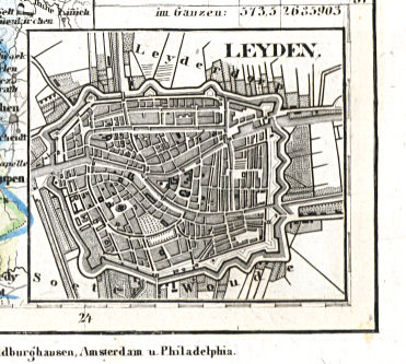
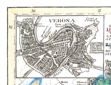
Opvallend in deze atlas is het grote aantal bijkaarten met (omgevingen van) grotere en ook kleinere steden. Sommige daarvan zij zo gedetailleerd dat ze als plattegrond gebruikt zouden kunnen worden. Op de pagina met plaatjes zijn ze in groter formaat afgebeeld. Het totale overzicht is te vinden in de lijst van kaarten, bijkaarten en schaal.
De nummering van de kaarten is verwarrend. In de inhoudsopgave – tevens aanwijzing voor de volgorde van inbinden – zijn de kaarten genummerd in een 'logische' volgorde. In mijn exemplaar zijn de kaarten ook in die volgorde ingebonden. Het is de nummering die hier gebruikt is, onder andere bij alle plaatjes. Maar op de kaarten zelf staan de nummers van de volgorde waarin de kaarten verschenen zijn (als je pech hebt, zijn de kaarten in die volgorde ingebonden).
Uit het overzicht van de nummering op de kaarten blijkt het volgende. De 'werktitel' van de atlas en het geplande aantal kaarten zijn in de loop van de jaren enkele malen gewijzigd. Min of meer chronologisch zijn deze 'werktitels' als volgt.
- (Meyer's) Atlas in 64 Karten
- (Meyer's) Universal Atlas / Universalatlas
- Meyer's (Universal) Atlas in 84 Karten
- Supplement zu ...
- Meyer's Universal Atlas in 90 Karten
Verder is ook te zien hoe de kaarten gebruikt werden voor de parallel uitgegeven Schul-Atlas. De 'werktitels' daarvan zijn als volgt terug te vinden.
- (Meyer's) Atlas in 18 Karten
- (Meyer's) Schulatlas
- Supplement zu ...
Uiteindelijk moet de Schul-Atlas een omvang van 39 bladen gehad hebben, dus het overzicht van de nummering op de kaarten geeft geen volledig beeld van de inhoud ervan.
Meyer's Universal-Atlas (1830-1840)
- Below is a description of the atlas in keywords. Related pages
- Title description
- Title: Meyer's Universal-Atlas
Publisher: Bibliographisches Institut
Year: 1830-1840 - Title page:
Neuester Universal-Atlas für Alte & Neue Erdkunde
Herausgegeben von J. Meyer
Chef des Bibliographischen Instituts in Hildburghausen, Amsterdam, Paris & Philadelphia.
Stahlstich, Druck & Verlag des Bibliographischen Instituts. Translation:
Newest Universal Atlas for Ancient and Modern Geography
Edited by J. Meyer
Chief of the Bibliographical Institute in Hildburghausen, Amsterdam, Paris & Philadelphia.
Engraved in steel, printed and published by the Bibliographical Institute. - This is the first atlas from the Bibliographische Institut. Almost 40 maps were also used in the Schul-Atlas (school atlas, 1830-1838). An edition with smaller size maps (18 × 12 cm), partially based on this atlas, was published under the title Pfennig-Atlas (1834-1841). The successors to this atlas, with approximately the same map size, are the Zeitungs-Atlas (1848-1857) and the Groschen-Atlas (1853-1869).
- The maps from all these publications, except for the ones in the Pfennig-Atlas, have also been used in the encyclopedias published by the Bibliographische Institut (Meyers Lexikon). From 1892 on the maps form the encyclopedia have in turn been used to compose a separate atlas.
- In the 1843-1877 time period two larger atlases, both in maps size and
number of maps, were published.
- Meyer's Großer Hand-Atlas (1843-1860, 170 map sheets and city plans)
- Meyer's Hand-Atlas (1862-1877, 100 map sheets)
- The headquarters of the Bibliographische Institut were in located Hildburghausen (Thuringia). The title of the atlas and text on the maps indicate that there were branches in Amsterdam, Paris, Philadelphia and New York. The maps were (also) engraved in Schweinfurt (Bavaria), approximately 60 kilometer southwest of Hildburghausen.
- Title: Meyer's Universal-Atlas
- Binding
- The maps of the atlas were published from 1830 through 1840 in installments. They were often bound unfolded. In my copy their size is 32 × 26.5 cm (W × H). Copies with folded maps are also known.
- Contents
- The atlas contains a title page, a table of contents and 90 map sheets – not 89 as called for in the table of contents because there are two maps #8 (Italia superior). See also the list of maps in table of contents order. Furthermore, there are 12 sheets with tables containing information on the different countries. They were compiled by A. Ravenstein in Frankfurt am Main. In my copy these tables are bound near the maps of the corresponding region.
- The maps have been engraved in steel and most of them are hand colored in outline. In the top margin is often the number of the map, given in the publication order. This is (usually) not the same as the number in the table of contents. On many maps the year of publication is indicated. Combined with the order of publication almost every map can be dated accurately. See the list of maps in publication order.
- On about two thirds of the maps the cartographer is mentioned. The most frequent names are those of Renner and Radefeld. On almost one third of the maps there is also the name of the engraver. See the list of cartographers and engravers. The location of the publisher is also mentioned on most maps. Besides Hildburghausen these locations are New York (1833-1838), Amsterdam (from 1835), Philadelphia (from 1837) and Paris (from 1838). Details can be found in the list of the publisher locations.
- The first map of the atlas gives information on astronomy. Thereafter are 16 maps about ancient geography. The other 73 maps describe the contemporary situation. This section starts with has 7 maps of the world and the continents. Thereafter are 53 maps of countries and regions in Europe, 2 regional maps of Asia, 5 of the Americas and 3 of Africa. The section on modern geography concludes with a chart on mountain heights and plans of the cities of Paris and London.
- Remarkable in this atlas is the large number of inset maps of larger and smaller cities (or their environs). Some of them are as detailed as to be used as a city plan. On the picture page they are shown enlarged. See also the list of maps, inset maps and scale.
- The numbering of the maps is confusing. In the table of contents – also meant to indicate the binding order – the maps are numbered in a 'logical' sequence. This is the numbering scheme used here, for the pictures of the atlas as well (in my copy the maps have been bound in this order). But the individual maps are numbered in the order in which they were published (unfortunately they have sometimes been bound in this publication order).
- From the list of numbering
on the maps the following is evident. The 'working title' of the
atlas, as well as the total number of maps, has changed several times
during the years. These 'working titles', more or less chronologically,
are as follows.
- (Meyer's) Atlas in 64 Karten
- (Meyer's) Universal Atlas / Universalatlas
- Meyer's (Universal) Atlas in 84 Karten
- Supplement zu ...
- Meyer's Universal Atlas in 90 Karten
- It is also clear how the maps of this atlas were used in the
Schul-Atlas (school atlas) which was published in parallel. Its 'working
titles' can be found as follows.
- (Meyer's) Atlas in 18 Karten
- (Meyer's) Schulatlas
- Supplement zu ...
© M. Witkam, 2010


