Stielers Karte / Atlas von Deutschland (1836-1876)
See below for (a summary of) this text in English.
Hieronder staat de beschrijving van de kaarten/atlas. Daarbij horen ook de volgende pagina's
Titelgegevens
Titel: Stielers Karte / Atlas von Deutschland
Uitgever: Justus Perthes, Gotha
Jaar: 1836-1876
Titel 1836:
Ad. Stieler's Karte von Deutschland, dem Königr. der Niederlande, dem Kgr.
Belgien und der Schweiz
mit den angränzenden Ländern
in XXV illum. Blättern in Folio.
Vertaling:
Ad. Stielers kaart van Duitsland, het Koninkrijk der Nederlanden, het
Koninkrijk België en Zwitserland
met de naburige gebieden
in 25 gekleurde kaartbladen in folioformaat.
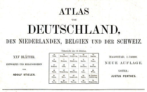
Titel 1867 (titelpagina):
Atlas von Deutschland, den Niederlanden, Belgien und der Schweiz.
XXV Blätter. Entworfen und herausgegeben von Adolf Stieler.
Massstab: 1:740000. Neue Auflage. Gotha: Justus Perthes.
Vertaling:
Atlas van Duitsland, Nederland, België en Zwitserland
25 kaartbladen. Ontwerp en redactie van Adolf Stieler.
Schaal: 1:740.000. Nieuwe uitgave. Justus Perthes, Gotha.
Titel 1867 (op de kaart):
Karte von Deutschland, dem Königr. der Niederlande, dem Kgr. Belgien,
der Schweiz
und den angränzenden Ländern, bis Paris, Lyon, Turin, Mailand, Venedig,
Ofen, Königsberg,
in XXV Blättern.
Entworfen und herausgegeben von Adolf Stieler.
Gezeichnet von Demselben, Hauptmann v. Stülpnagel und J.C. Bär.
Gestochen von Edler, Haase, Baumgarten, Thiel, Leidenfrost.
Gotha, bei Justus Perthes. Neue Auflage 1867.
Vertaling:
Kaart van Duitsland, het Koninkrijk der Nederlanden, het Koninkrijk
België, Zwitserland
en de naburige gebieden tot Parijs, Lyon, Turijn, Milaan, Venetië, Pest,
Königsberg,
in 25 kaartbladen.
Ontwerp en redactie van Adolf Stieler.
Getekend door hemzelf, hoofdman v. Stülpnagel en J.C. Bär.
Gegraveerd door Edler, Haase, Baumgarten, Thiel, Leidenfrost.
Gotha, Justus Perthes. Nieuwe uitgave 1867.
-
Adolf Stieler (1775-1836) was vanaf het begin van de 19e eeuw werkzaam als cartograaf. Zijn bekendste werk is Stielers Hand-Atlas, ook uitgegeven door Justus Perthes in Gotha.
 Stielers Atlas von Deutschland ...
Titelpagina 1867 (gedeeltelijk) - Het begrip 'Duitsland' staat voor de Duitse Bond (1815-1866). Daartoe behoorde ondere andere ook 'Duits-Oostenrijk', maar niet de oostelijke provincies van het Koninkrijk Pruisen.
- De kaarten waren apart verkrijgbaar of als extra kaarten bij Stielers Hand-Atlas.
- Er zijn ook kleinere versies van deze kaart verschenen.
- Diez, von Stülpnagel, Bär: Deutschland, Königr. der Niederlande, Königr. Belgien und die Schweiz (de 'grote Diez')
- Diez, Bär: Post- und Reise-(Eisenbahn-)Karte von Deutschland und den anliegenden Ländern (de 'kleine Diez', voorloper van de 'grote Diez')
Kaarten
De kaart bestaat uit 25 bladen genummerd in Romeinse cijfers I, II, III, ... , XXIV, XXV. Hieruit kon één grote kaart worden samengesteld (5 bladen horizontaal en 5 verticaal). De kaartbladen 1 t/m 5 bestaan steeds uit twee halve bladen: 1a en 1b, 2a en 2b enz. Daarbij vormen de bladen met de nummers 1a t/m 5a de bovenrand van de samengestelde kaart en de bladen met de nummers 1b t/m 5b de benedenrand. Zie ook de onderlinge ligging van de kaarten. Hierdoor komt de plaats van uitgave, Gotha, in het midden van een kaartblad te liggen – het is niet duidelijk of dat ook inderdaad de bedoeling is geweest.
De afmetingen van de kaartbladen zijn ongeveer 36,0 × 33,5 cm (B × H, bladen 1 t/m 5) of 36,0 × 31,5 cm (bladen 6 t/m 25), met ruime witmarges. De afmetingen van de samengestelde grote kaart zijn 179 × 160 cm (zonder witmarges). De kaarten zijn geproduceerd in koperdruk en met de hand ingekleurd (randkleur, meestal met brede 'bies'). De schaal is bij benadering 1:750.000.
Vanaf 1857 was bij uitgeverij Justus Perthes een systeem van datering van de kaarten in gebruik waarbij de graveerdatum (maand en jaar) werd aangegeven in een code. Bij de uitgave van 1867 betekent de code VI.VII dan juni 1867 (dus: maand en eindcijfer van het jaar). Zie ook het overzicht van kaarten en datering van de uitgave van 1867.
De kaart is topografisch van karakter, met nadruk op (spoor)wegen en staatkundige indeling. Het reliëf is niet zo gedetailleerd uitgewerkt als in Stielers Hand-Atlas. Het op de kaart afgebeelde gebied beslaat het toenmalige Duitsland (tot 1866 een aanduiding van de Duitse Bond) met Nederland, België, Noordoost-Frankrijk, Zwitserland en Noord-Italië. Tot de Duitse Bond behoorde ook 'Duits-Oostenrijk' maar niet het oostelijke deel van het Koninkrijk Pruisen. De kaart loopt dus maar tot Königsberg in Oost-Pruisen.
Uitgaven
De kaart is in de periode 1836-1876 onder verschillende titels verschenen.
- Ad. Stieler's Karte von Deutschland, dem Königr. der Niederlande, dem Kgr. Belgien und der Schweiz mit den angränzenden Ländern in XXV illum. Blättern in Folio (1836, 1840, 1847, 1850, 1854, 1862)
- Atlas von Deutschland, den Niederlanden, Belgien und der Schweiz. XXV Blätter. Entworfen und herausgegeben von Adolf Stieler (1867)
- Karte des Deutschen Reiches und der Alpenländer in XVV Blättern von Adolf Stieler (1876)
bron: Espenhorst
Stielers Karte / Atlas von Deutschland (1836-1876)
- Below is a description of the maps/atlas in keywords. Related pages
- Title description
- Title: Stielers Karte / Atlas von Deutschland
Publisher: Justus Perthes, Gotha
Year: 1836-1876 - Title 1836:
Ad. Stieler's Karte von Deutschland, dem Königr. der Niederlande, dem Kgr.
Belgien und der Schweiz
mit den angränzenden Ländern
in XXV illum. Blättern in Folio. Translation:
Ad. Stielers map of Germany, the Kingdom of the Netherlands, the Kingdom of Belgium and Switzerland
with the neighboring countries
in 25 colored folio size maps sheets. - Title 1867 (title page):
Atlas von Deutschland, den Niederlanden, Belgien und der Schweiz.
XXV Blätter. Entworfen und herausgegeben von Adolf Stieler.
Massstab: 1:740000. Neue Auflage. Gotha: Justus Perthes. Translation:
Atlas of Germany, the Netherlands, Belgium and Switzerland.
25 map sheets. Designed and edited by Adolf Stieler.
Scale 1:740,000. New edition. Justus Perthes, Gotha. - Title 1867 (on the map):
Karte von Deutschland, dem Königr. der Niederlande, dem Kgr. Belgien,
der Schweiz
und den angränzenden Ländern, bis Paris, Lyon, Turin, Mailand, Venedig, Ofen, Königsberg,
in XXV Blättern.
Entworfen und herausgegeben von Adolf Stieler.
Gezeichnet von Demselben, Hauptmann v. Stülpnagel und J.C. Bär.
Gestochen von Edler, Haase, Baumgarten, Thiel, Leidenfrost.
Gotha, bei Justus Perthes. Neue Auflage 1867. Translation:
Map of Germany, the Kingdom of the Netherlands, the Kingdom of Belgium and Switzerland
and the neighboring countries up to Paris, Lyon, Turin, Milan, Venice, Ofen, Königsberg,
in 25 map sheets.
Designed and edited by Adolf Stieler.
Drawn by himself, Captain v. Stülpnagel and J.C. Bär.
Engraved by Edler, Haase, Baumgarten, Thiel, Leidenfrost.
Justus Perthes, Gotha. New edition 1867. -
Adolf Stieler (1775-1836) had been working as a cartographer from the beginning of the 19th century. His best-known work is Stielers Hand-Atlas, also published by Justus Perthes in Gotha.
Stielers Atlas von Deutschland ...
Title page 1867 (partially) - The word 'Germany' in the title is a short designation of the German Confederation (1815-1866), part of which was also 'German Austria' but not the eastern provinces of the Kingdom of Prussia.
- The maps were sold separately or as additional maps to Stielers Hand-Atlas.
- Smaller versions of this map were also available.
- Diez, von Stülpnagel, Bär: Deutschland, Königr. der Niederlande, Königr. Belgien und die Schweiz (the 'major Diez')
- Diez, Bär: Post- und Reise-(Eisenbahn-)Karte von Deutschland und den anliegenden Ländern (the 'minor Diez', predecessor of the 'major Diez')
- Title: Stielers Karte / Atlas von Deutschland
- Maps
- The map consists of 25 sheets with Roman numerals I, II, III... XXIV, XXV. One large map (5 sheets across and 5 down) could be composed out of these 25 sheets. The sheets 1 through 5 each contain two half sheets: 1a and 1b, 2a and 2b etc. The sheets numbered 1a through 5a make up for the upper edge of the large map and the sheets numbered 1b through 5b the lower edge. See also the lay-out of map sheets. Because of this lay-out the city of Gotha, home of the publishing company, is situated in the center of a sheet – it is unclear if this has been intentional.
- The dimensions of the map sheets are approximately 36,0 × 33,5 cm (W × H, sheets 1 through 5) or 36,0 × 31,5 cm (sheets 6 through 25), with ample margins. The composite map measures 179 × 160 cm (without margins). The maps have been produced in copper engraving; they are hand colored in outline, usually with an edging. The scale is approximately 1:750,000.
- From 1857 the publisher Justus Perthes employed a dating system for the maps, where the engraving date (month and year) is given in an encoded form. In the 1867 edition of the maps the code VI.VII means June 1867 (month and last digit of the year). See also the list of maps and date of the 1867 edition.
- The maps have a topographical nature with an emphasis on (rail)roads and political subdivision. The relief has not been indicated as clearly as in Stielers Hand-Atlas. The depicted area consists of Germany (until 1866 an indication of the German Confederation) with the Netherlands, Belgium, Northeast France, Switzerland and North Italy. Part of the German Confederation was also 'German Austria' but not the eastern part of the Kingdom of Prussia. The map therefore extends eastward only to Königsberg in East Prussia.
- Editions
- The map has been published under several titles in the 1836-1876
period.
- Ad. Stieler's Karte von Deutschland, dem Königr. der Niederlande, dem Kgr. Belgien und der Schweiz mit den angränzenden Ländern in XXV illum. Blättern in Folio (1836, 1840, 1847, 1850, 1854, 1862)
- Atlas von Deutschland, den Niederlanden, Belgien und der Schweiz. XXV Blätter. Entworfen und herausgegeben von Adolf Stieler (1867)
- Karte des Deutschen Reiches und der Alpenländer in XVV Blättern von Adolf Stieler (1876)
- source: Espenhorst
- The map has been published under several titles in the 1836-1876
period.
© M. Witkam, 2008
![]()
![]()