Miniatur-Bibliothek, Hand-Atlas 3e reeks (ca. 1907 - ca. 1914)
See below for (a summary of) this text in English.
Hieronder staat de beschrijving van de atlas. Daarbij horen ook de volgende pagina's
- Plaatjes van de atlas
- Tabellen en lijsten bij de atlas
- Vergelijking (plaatjes) met de 2e reeks
Titelgegevens
Titel: Miniatur-Bibliothek, Hand-Atlas
Uitgever: "Verlag für Kunst und Wissenschaft" Albert Otto Paul, Leipzig
Jaar: ca. 1907 - ca. 1914 (3e reeks)
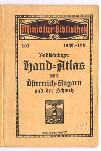
Omslagtitel Hand-Atlas von Österreich-Ungarn:
Miniatur-Bibliothek 151
Vollständiger Hand-Atlas von Österreich-Ungarn und der Schweiz
Ges. geschützt.
Vertaling:
Miniatuurbibliotheek 151
Volledige Handatlas van Oostenrijk-Hongarije en Zwitserland
Gepatenteerd.
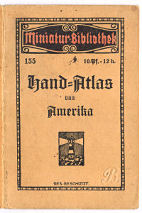
Omslagtitel Hand-Atlas von Amerika:
Miniatur-Bibliothek 155
Hand-Atlas von Amerika
Ges. geschützt.
Vertaling:
Miniatuurbibliotheek 155
Handatlas van Amerika
Gepatenteerd.
- Dit is de derde reeks van atlassen uit de Miniatur-Bibliothek uitgegeven door "Verlag für Kunst und Wissenschaft" Albert Otto Paul. Kenmerkend voor de atlassen uit deze reeks is de band met de tekst 'Miniatur-Bibliothek' in een decoratief kader.
- De reeks atlassen bestaat uit 6 delen (tussen haakjes het nummer in de
Miniatur-Bibliothek)
- Duitsland (150)
- Oostenrijk-Hongarije, Zwitserland (151)
- Europa (152)
- Azië (153)
- Afrika, Australië (154)
- Amerika (155)
- De datering (ca. 1907 - ca. 1914) is ontleend aan de literatuur. In de atlassen zelf is geen jaar van uitgave te vinden.
- De kaarten van de atlassen uit deze reeks zijn, iets vergroot, onder andere ook gebruikt in Singers neuer vollständiger Taschen-Atlas (1913).
Band
De atlassen zijn gebonden in een lichtoranje buigzame kartonnen band van 8 × 12 cm, (B × H). Op de voorkant staat het volgende.
- De tekst "Miniatur-Bibliothek", het nummer in de Miniatur-Bibliothek (150-155) en de prijs in Duitsland (10 Pf.) en Oostenrijk (12 h.)
- De titel
- Het logo van de uitgever (AOP = Albert Otto Paul)
- De tekst 'Ges. geschützt' (Gesetzlich geschützt)
Inhoud
De atlassen bestaan uit kaarten met op de achterkant tekst. Het aantal bladzijden tekst is dus steeds gelijk aan het aantal kaartbladzijden. Er is geen titelpagina. Op de tekstbladzijden staan allerlei statistische gegevens van de landen die op de kaarten zijn afgebeeld.
De atlas van Duitsland bevat 5 kaarten (10 bladzijden): een overzichtskaart, drie deelkaarten en een kaart van de koloniën. De atlas van Oostenrijk-Hongarije en Zwitserland heeft 6 kaarten (12 bladzijden): een overzichtskaart en vier deelkaarten van Oostenrijk-Hongarije, en een kaart van Zwitserland. De andere vier atlassen (Europa met 7 kaarten; Azië, Afrika en Australië, Amerika met ieder 5 kaarten) bevatten steeds een overzichtskaart en enkele deelkaarten van het betreffende werelddeel. Zie voor de details de lijst van kaarten, bijkaarten en schaal.
De kaarten zijn uitgevoerd in kleurenlithografie. Ze zijn staatkundig gekleurd (vlakkleur). De bergen zijn op de deelkaarten aangegeven met een zwarte arcering; op de overzichtskaarten wordt geen reliëf getoond. Onderaan de kaarten staan de schaal en een schaalstok.
Vergelijking met de 2e reeks
De inhoud van de atlassen wijkt nauwelijks af van die uit de 2e reeks. De belangrijkste verschillen met de eerdere reeks
- De atlassen hebben nieuwe banden
- De kleuren op de kaarten zijn (veel) minder nauwkeurig geplaatst
- De statistische teksten zijn bijgewerkt
Bronnen:
- Aardrijkskunde & Geschiedenis, jaargang 2002, nummer 2 (Overzicht 1e reeks, Hand-Atlas Deutschland 1910)
- Jürgen Espenhorst: Petermann's Planet, volume II (p. 1301)
Geraadpleegde exemplaren:
- Hand-Atlas von Österreich-Ungarn
- Hand-Atlas von Amerika
Miniatur-Bibliothek, Hand-Atlas 3rd series (ca. 1907 - ca. 1914)
- Below is a description of the atlas in keywords. Related pages
- Pictures of the atlas
- Tables and lists to the atlas
- Comparison (pictures) with the 2nd series
- Title description
- Title: Miniatur-Bibliothek, Hand-Atlas
Publisher: "Verlag für Kunst und Wissenschaft" Albert Otto Paul, Leipzig
Year: ca. 1907 - ca. 1914 (3rd series) - Cover title Hand-Atlas von Österreich-Ungarn und der Schweiz:
Miniatur-Bibliothek 151
Vollständiger Hand-Atlas von Österreich-Ungarn und der Schweiz
Ges. geschützt. Translation:
Miniature Library 151
Complete Hand Atlas of Austria-Hungary and Switzerland
Patented. - Cover title Hand-Atlas von Amerika:
Miniatur-Bibliothek 155
Hand-Atlas von Amerika
Ges. geschützt. Translation:
Miniature Library 155
Hand Atlas of the Americas
Patented. - This is the third series of atlases from the Miniatur-Bibliothek (Miniature Library) published by "Verlag für Kunst und Wissenschaft" (Publishing House for Art and Science) Albert Otto Paul. The atlases of this series are characterized by their front cover with the text 'Miniatur-Bibliothek' inside a decorative frame.
- The series consists of 6 volumes (in parentheses the number in the
Miniatur-Bibliothek)
- Germany (150)
- Austria-Hungary (151)
- Europe (152)
- Asia (153)
- Africa, Australia (154)
- The Americas (155)
- The years (ca. 1907 - ca. 1914) have been derived from the literature. No publication year is mentioned in the atlases themselves.
- The maps of these atlases, slightly enlarged, have also been used in Singers neuer vollständiger Taschen-Atlas (1913).
- Title: Miniatur-Bibliothek, Hand-Atlas
- Binding
- The atlases are bound in an light orange flexible cardboard binding
measuring 8 × 12 cm (W × H). The
front cover contains the following information.
- The text "Miniatur-Bibliothek", the volume number in the Miniatur-Bibliothek (150-155) and the price in Germany (10 Pf.) and Austria (12 h.)
- The title
- The company logo (AOP = Albert Otto Paul)
- The text 'Ges. geschützt' (Gesetzlich geschützt)
- The atlases are bound in an light orange flexible cardboard binding
measuring 8 × 12 cm (W × H). The
front cover contains the following information.
- Contents
- The atlases consist of maps with text on the verso. The number of text pages therefore equals the number of map pages. There is no title page. The text pages contain statistical information on the countries depicted on the maps.
- The atlas of Germany contains 5 maps (10 pages): a general map, three regional maps and a map of the colonies. The atlas of Austria-Hungary and Switzerland has 6 maps (12 pages): a general map and four regional maps of Austria-Hungary, and a map of Switzerland. All of the remaining four atlases (Europe with 7 maps; Asia, Africa and Australia, the Americas with 5 maps each) contain a general map and some regional maps of the continent(s) in question. Details can be found in the list of maps, inset maps and scale.
- The maps have been produced in color lithography. They are colored politically (area color). Mountains on the regional maps are indicated with black hachuring; no relief is shown on the general maps. In the bottom margin are the scale and a linear scale.
- In comparison with the 2nd series
- The maps in the atlases are almost identical to those in the 2nd series. The main differences with the earlier series
- The covers of the atlases have been redesigned
- The colors on the maps are positioned less accurately
- The statistics have been updated
- The maps in the atlases are almost identical to those in the 2nd series. The main differences with the earlier series
- Sources:
- Aardrijkskunde & Geschiedenis, year 2002, number 2 (Overview of 1st series, Hand-Atlas Deutschland 1910) in Dutch
- Jürgen Espenhorst: Petermann's Planet, volume II (p. 1301)
- Copies consulted:
- Hand-Atlas von Österreich-Ungarn
- Hand-Atlas von Amerika
© M. Witkam, 2012


