Glaser's Schul-Atlas, 1e druk (1846)
See below for (a summary of) this text in English.
Hieronder staat de beschrijving van de atlas. Daarbij horen ook de volgende pagina's
- Plaatjes van de atlas
- Tabellen en lijsten bij de atlas
- Vergelijking (plaatjes) van Glaser's Kleiner Atlas (1848) en Glaser's Schul-Atlas (1846)
Titelgegevens
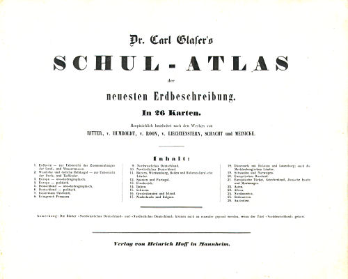
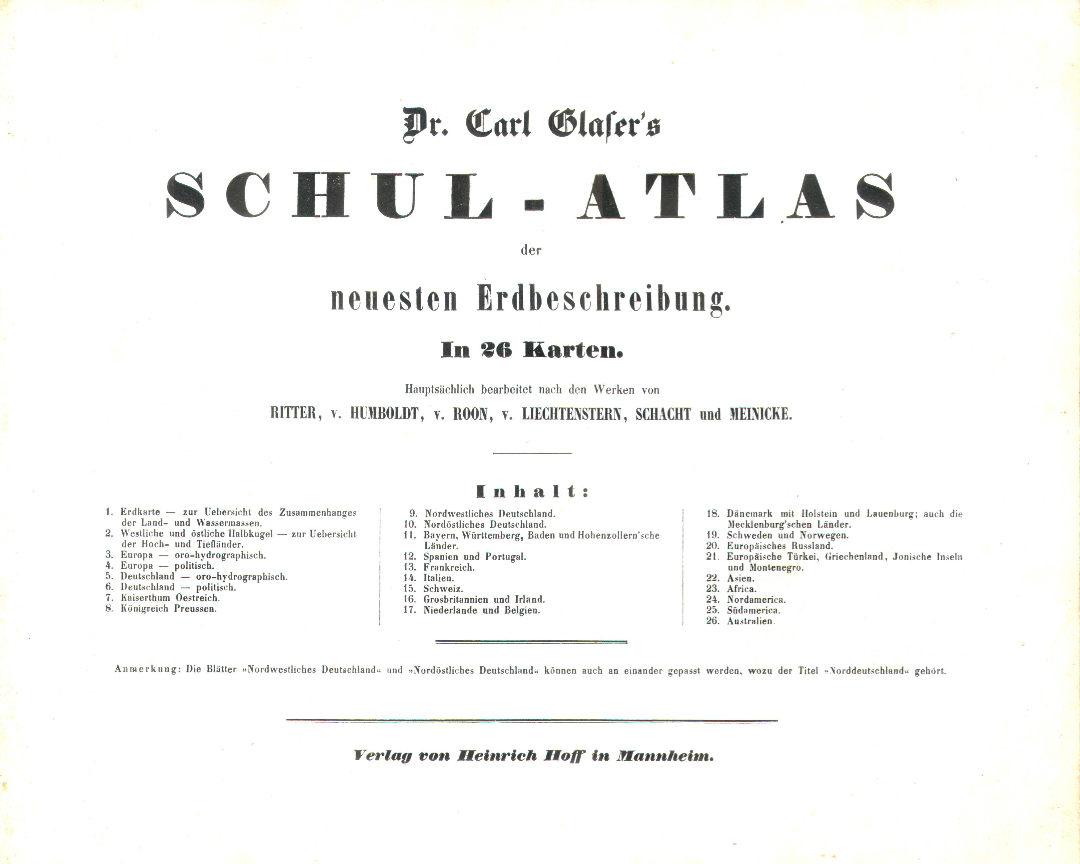
Titel: Schul-Atlas der neuesten Erdbeschreibung
Auteur: Carl Glaser
Uitgever: Heinrich Hoff, Mannheim
Jaar: 1846 (1e druk)
Titelpagina:
Dr. Carl Glaser's Schul-Atlas der neuesten Erdbeschreibung.
In 26 Karten.
Hauptsächlich bearbeitet nach den Werken von
Ritter, v. Humboldt, v. Roon, v. Liechtenstern, Schacht und Meinicke.
Inhalt: ...
Verlag von Heinrich Hoff in Mannheim.
Vertaling:
Dr. Carl Glaser's Schoolatlas van de hedendaagse aardrijkskunde.
In 26 kaartbladen.
Voornamelijk bewerkt naar de uitgaven van
Ritter, v. Humboldt, v. Roon, v. Liechtenstern, Schacht en Meinicke.
Inhoud: ...
Uitgeverij Heinrich Hoff, Mannheim.
-
Op de titelpagina van de atlas staat geen jaartal, maar het voorwoord is geschreven in zomer van 1846.
 Dr. Carl Glaser's Schul-Atlas (1846)
Titelpagina - De kaartbladen 9 en 10 (Noord-Duitsland) kunnen aan elkaar of los ingebonden zijn.
- Van deze atlas is een verkleinde uitgave verschenen: De kaartbladen uit deze schoolatlas zijn daarvoor, verkleind van 30 × 25 cm naar 19 × 15 cm, opnieuw getekend. Zie ook de pagina waarop de kaarten van deze twee atlassen vergeleken worden.
- Naast deze atlas met voornamelijk staatkundige kaarten was ook leverbaar de Topisch-Physikalischer Atlas (1e druk, 1844) met natuurkundige en thematische kaarten.
- Een eerdere atlas van Carl Glaser, de (Hand-)Atlas über alle Theile der Erde (1e druk, 1842), werd ook aanbevolen voor schoolgebruik. Daarom wordt, heel verwarrend, ook die atlas wel de 'schoolatlas' genoemd.
Band
Mijn exemplaar van de atlas is gebonden in een eenvoudige kartonnen band van 30,5 × 25 cm (B × H). De kaarten (30 × 24,5 cm) zijn ongevouwen ingebonden.
Inhoud
De atlas bevat een titelpagina met inhoudsopgave, vermelding van auteur en uitgever en verwijzing naar de geraadpleegde literatuur; verder een voorwoord van 1 bladzijde en 26 kaartbladen. Er zijn 2 wereldkaarten en 7 kaarten van de werelddelen: van Europa is er een natuurkundige en een staatkundige kaart. De overige kaarten zijn van landen in Europa (17 bladen), met de nadruk op Duitsland (6 bladen). Zie voor de details de lijst van kaarten, bijkaarten en schaal.
De kaarten zijn vervaardigd in lithografie (steendruk). Ze zijn meestal met de hand gekleurd (randkleur). Vier van de kaartbladen zijn in kleur gedrukt: de wereldkaart met blauw voor de zee (Nº 1), de kaart van westelijk en oostelijk halfrond met hoogtekleuren (Nº 2) en de natuurkundige kaarten van Europa (Nº 3) en Duitsland (Nº 5), met blauw voor de zee en bruin voor het gebergte. Bij de laatste twee hoort ook steeds een staatkundige kaart. Onderaan veel kaarten staat de vermelding 'Ausgeführt in dem geogr. lithogr. Institute v. Dr. C. Glaser in Darmstadt'. Er worden geen cartografen of graveurs vermeld. De bladen zijn niet genummerd: heel onhandig voor een schoolboek.
Glaser's Schul-Atlas, 1st edition (1846)
- Below is a description of the atlas in keywords. Related pages
- Pictures of the atlas
- Tables and lists to the atlas
- Comparison (pictures) of Glaser's Kleiner Atlas (1848) and Glaser's Schul-Atlas (1846)
- Title description
- Title: Schul-Atlas der neuesten
Erdbeschreibung
Author: Carl Glaser
Publisher: Heinrich Hoff, Mannheim
Year: 1846 (1st edition) - Title page:
Dr. Carl Glaser's Schul-Atlas der neuesten Erdbeschreibung.
In 26 Karten.
Hauptsächlich bearbeitet nach den Werken von
Ritter, v. Humboldt, v. Roon, v. Liechtenstern, Schacht und Meinicke.
Inhalt: ...
Verlag von Heinrich Hoff in Mannheim. Translation:
Dr. Carl Glaser's School Atlas of Modern Geography
In 26 map sheets.
Mainly produced according to the works of
Ritter, v. Humboldt, v. Roon, v. Liechtenstern, Schacht and Meinicke.
Contents: ...
Heinrich Hoff Publishers in Mannheim. -
There is no year on the title page of the atlas, but the preface has been written in the summer of 1846.
Dr. Carl Glaser's Schul-Atlas (1846)
Title page - The map sheets 9 and 10 (Northern Germany) can be bound joined or separately.
- A reduced size edition of this atlas was published as The maps from this atlas have been redrawn, reduced from 30 × 25 cm to 19 × 15 cm. See also the page where the maps of both atlases are shown in comparison.
- Alongside this atlas, with mainly political maps, was available the Topisch-Physikalischer Atlas (1st edition, 1844) with physical and thematic maps.
- A previous atlas by Carl Glaser, the (Hand-)Atlas über alle Theile der Erde (1st edition, 1842), was also recommended for school use. That other atlas is therefore, confusingly, also referred to as the 'school atlas'.
- Title: Schul-Atlas der neuesten
Erdbeschreibung
- Binding
- My copy of the atlas is bound in a simple cardboard binding of 30.5 × 25 cm (W × H). The maps (30 × 24.5 cm) are bound unfolded.
- Contents
- The atlas has a title page with table of contents, mentioning the author and publisher and referring to the sources used, a preface of 1 page and 26 map sheets. There are 2 world maps en 7 maps of the continents: both a physical and a political map of Europe. The other maps depict European countries (17 sheets) and especially Germany (6 sheets). Details can be found in the list of maps, inset maps and scale.
- The maps have been printed lithographically. Most of them are hand colored in outline. Four of the maps are printed in color: the world map (Nº 1) with blue for the seas, the map of the hemispheres with hypsometric coloring (Nº 2) and the physical maps of Europe (Nº 3) and Germany (Nº 5), with blue for the seas and brown for mountain areas. These two physical maps both have a corresponding political map. In the lower margin of most of the maps is the text 'Ausgeführt in dem geogr. lithogr. Institute v. Dr. C. Glaser in Darmstadt'. No cartographers or engravers are mentioned. The sheets are not numbered: rather clumsy for a school book.
© M. Witkam, 2009
![]()
![]()