Perthes' Alldeutscher Atlas, 2e druk (1903)
See below for (a summary of) this text in English.
Hieronder staat de beschrijving van de atlas. Daarbij horen ook de volgende pagina's
Titelgegevens
Titel: Justus Perthes' Alldeutscher Atlas
Uitgever: Justus Perthes, Gotha
Jaar: 1903 (2e druk)
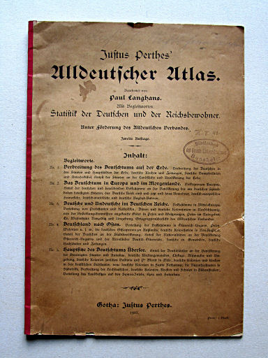
Titelpagina:
Justus Perthes' Alldeutscher Atlas.
Bearbeitet von Paul Langhans.
Mit Begleitworten: Statistik der Deutschen und der Reichsbewohner.
Unter Förderung des Alldeutschen Verbandes.
Zweite Auflage. Inhalt: ...
Gotha: Justus Perthes. 1903.
Vertaling:
Justus Perthes' Pangermaanse Atlas.
Bewerkt door Paul Langhans.
Met begeleidende tekst: Statistiek van de Duitsers en de inwoners van het Rijk.
Onder aanmoediging van de Pangermaanse Liga.
Tweede druk. Inhoud: ...
Gotha: Justus Perthes. 1903.
- Deze atlas is deel van de reeks Duitse atlassen van Paul Langhans.
- De atlas gaat voornamelijk over de verspreiding van de Duitsers over de wereld. Dit thema was ook onderwerp van de in 1897 verschenen 'Deutscher Kolonial-Atlas' van Paul Langhans.
- Het vervaardigen van de atlas werd gesponsord door het Alldeutscher Verband, een pangermanistische organisatie. Dit exemplaar was een geschenk van de voorzitter, Ernst Hasse.
Band
De atlas heeft een eenvoudige bruine papieren band met linnen rug. Op de voorkant staan titel en inhoudsopgave, op de achterkant een wervende tekst over het blad 'Deutsche Erde'. Op het schutblad voorin staat nadere informatie over het 'Alldeutscher Verband'; achterin staat een lijst van kaarten over het 'Deutschtum' van Paul Langhans.
Inhoud
De atlas bevat 8 tekstpagina’s en 5 kaartbladen. Op de eerste tekstpagina staan titel en inhoudsopgave, net als op de voorkant van de band. De andere zeven pagina’s bevatten allerlei statistische gegevens over de inwoners van Duitsland en over de Duitsers in andere landen.
De vijf kaarten – vervaardigd in kopergravure en gedrukt in kleurenlithografie – geven informatie over de verspreiding van de Duitsers over de wereld en in Europa, over de bewoners van Duitsland, over de Duitsers in Midden- en Oost-Europa, en over de Duitse nederzettingen buiten Europa. Zie ook de inhoudsopgave.
Uitgaven
Dit is de 2e druk van de atlas (1903). De 1e druk is uitgegeven in 1900, de 3e in 1905.
Perthes' Alldeutscher Atlas, 2nd edition (1903)
- Below is a description of the atlas in keywords. Related pages
- Title description
- Title: Justus Perthes' Alldeutscher Atlas
Publisher: Justus Perthes, Gotha
Year: 1903 (2nd edition) - Title page:
Justus Perthes' Alldeutscher Atlas.
Bearbeitet von Paul Langhans.
Mit Begleitworten: Statistik der Deutschen und der Reichsbewohner.
Unter Förderung des Alldeutschen Verbandes.
Zweite Auflage. Inhalt: ...
Gotha: Justus Perthes. 1903. Translation:
Justus Perthes' Pan-German Atlas.
Edited by Paul Langhans.
With an accompanying text: Statistics of the Germans and the inhabitants of the Empire.
Under encorragement of the Pan-German League
Second edition. Contents: ...
Gotha: Justus Perthes. 1903. - This atlas is part of the series of German atlases by Paul Langhans.
- Main subject of the atlas is the distribution of the Germans over the world. This theme was also subject of the 'Deutscher Kolonial-Atlas' published by Paul Langhans in 1897.
- The production of the atlas was sponsored by the Alldeutscher Verband, a pangermanist organization. This copy was a gift from its president, Ernst Hasse.
- Title: Justus Perthes' Alldeutscher Atlas
- Binding
- The atlas has a plain brown paper binding with a cloth spine. On the front cover are the title and the table of contents, on the rear cover an advertising text about the magazine 'Deutsche Erde'. The front endpaper contains information on the 'Alldeutscher Verband'; in the back is a list of maps on 'Deutschtum' (Germanism) by Paul Langhans.
- Contents
- The atlas has 8 text pages and 5 map sheets. On the first text page are title and table of contents just as on the front cover. The other seven text pages contain statistical data on the inhabitants of Germany and on the Germans in other countries.
- The five maps – produced in copper engraving and printed in color lithography – contain information on the distribution of the Germans around the world and in Europe, the inhabitants of Germany, the Germans in Central and Eastern Europe and on the German settlements outside Europe. See also the table of contents.
- Editions
- This is the 2nd edition of the atlas (1903). The 1st edition was published in 1900, the 3rd in 1905.
© M. Witkam, 2011


