Peips Taschen-Atlas über alle Teile der Erde (1904)
See below for (a summary of) this text in English.
Hieronder staat de beschrijving van de atlas. Daarbij horen ook de volgende pagina's
Titelgegevens
Titel: Peips Taschen-Atlas über alle Teile der Erde
Uitgever: Deutsche Verlags-Anstalt, Stuttgart / Leipzig
Jaar: 1904
Titelpagina:
Taschen-Atlas über alle Teile der Erde
In 36 Haupt- und 70 Nebenkarten
von Chr. Peip Kartograph in Eisenach
Mit geographisch-statistischen Notizen von Otto Weber
Stuttgart und Leipzig Deutsche Verlags-Anstalt 1904
Vertaling:
Zakatlas van de gehele Aarde
Met 36 hoofd- en 70 bijkaarten
door Chr. Peip, cartograaf in Eisenach
Met geografische en statistische aantekeningen door Otto Weber
Stuttgart en Leipzig Deutsche Verlags-Anstalt 1904
- Christian Peip was als zelfstandig cartograaf gevestigd in Eisenach. Hij maakte atlassen en (wandel)kaarten voor verschillende uitgevers. Zie ook het overzicht.
- Over Otto Weber, de auteur van het geografisch-statistische deel, heb ik geen gegevens kunnen vinden.
- Voor zover bekend is dit de enige uitgave van deze atlas.

Band
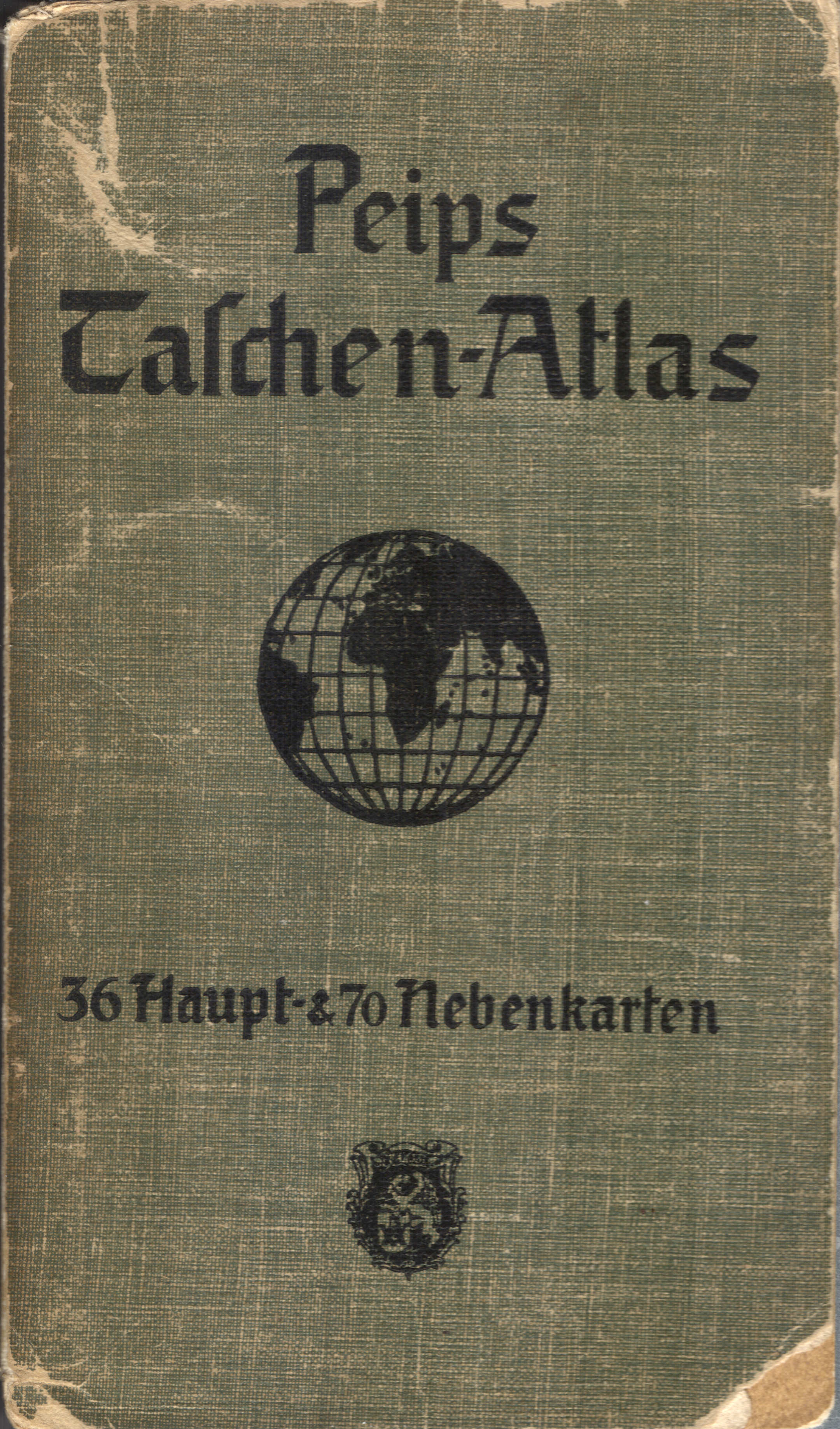
De atlas heeft een flexibele band van stevig papier beplakt met 'calico' (gedrukt katoen) met afmetingen 9 × 15,5 cm (B × H). Op de voorkant staan de titel 'Peips Taschen-Atlas', een wereldbol en het aantal kaarten. De titel staat ook op de rug.
Inhoud
De atlas bestaat uit een tekstdeel van 80 bladzijden en een deel met 36 kaarten, ieder op twee bladzijden. Het tekstdeel begint met een titelpagina; op de achterkant daarvan staan de namen van de drukker (Deutsche Verlags-Anstalt in Stuttgart) en de papierleverancier (Papierfabrik Salach in Salach, Württemberg). Daarna komen twee bladzijden met de inhoudsopgave. De overige 76 bladzijden zijn gevuld met statistische gegevens over de alle landen in de wereld.
Het kaartendeel begint met 2 wereldkaarten. Daarna komen 21 kaarten van Europa waaronder 9 van Duitsland. Vervolgens zijn er 4 kaarten van Azië, 3 van Afrika, 1 van Australië en 5 van Noord- en Zuid-Amerika. Zie ook de inhoudsopgave.
De kaarten zijn op matglanzend papier gedrukt in kleurenlithografie. De beide wereldkaarten zijn grotendeels thematisch gekleurd: hoogten en diepten, vegetatie, volkeren. De andere kaarten hebben een staatkundige kleuring. Er zijn veel bijkaartjes van stedelijke gebieden; zie de lijst van kaarten, bijkaarten en schaal. De plaatsing van de kleuren is – in ieder geval in dit exemplaar – niet helemaal nauwkeurig, wat vooral opvalt bij de stadsplattegronden.
Het formaat van de kaartbladen is 18 × 15,5 cm. Het formaat van het kaartkader is zelfs maar 14,5 × 12,5 cm. Ondanks dit kleine formaat zijn de kaarten bijzonder duidelijk en, zeker met een vergrootglas, goed leesbaar.
Peips Taschen-Atlas über alle Teile der Erde (1904)
- Below is a description of the atlas in keywords. Related pages
- Title description
- Title: Peips Taschen-Atlas über alle Teile der Erde
Publisher: Deutsche Verlags-Anstalt, Stuttgart / Leipzig
Year: 1904 - Title page:
Taschen-Atlas über alle Teile der Erde
In 36 Haupt- und 70 Nebenkarten
von Chr. Peip Kartograph in Eisenach
Mit geographisch-statistischen Notizen von Otto Weber
Stuttgart und Leipzig Deutsche Verlags-Anstalt 1904 Translation:
Pocket Atlas of the entire Earth
In 36 main and 70 inset maps
by Chr. Peip, cartographer in Eisenach
With geographical and statistical notes by Otto Weber
Stuttgart and Leipzig Deutsche Verlags-Anstalt 1904 - Christian Peip was active as an independent cartographer in Eisenach. He produced atlases and (hiking) maps for several publishers. See also the overview.
- I have not been able to find further informaton on Otto Weber, the author of the geographical and statistical notes.
- To my knowledge this is the only edition of this atlas.
- Title: Peips Taschen-Atlas über alle Teile der Erde
- Binding
- The atlas has a flexible binding of sturdy paper pasted with calico measuring 9 × 15.5 cm (W × H). On the front cover are the title 'Peips Taschen-Atlas', a globe and the number of maps. The title is also printed on the spine.
- Contents
- The atlas consists of a text section with 80 pages and a section with 36 double sided maps. The text section begins with a title page; on the verso the names of the printer (Deutsche Verlags-Anstalt in Stuttgart) and the paper supplier (Papierfabrik Salach in Salach, Württemberg) are mentioned. Then come two pages of the table of contents. The remaining 76 pages are filled with statistics on all countries in the world.
- The map section begins with 2 world maps. Thereafter are 21 maps of Europe including 9 of Germany. Then there are 4 maps of Asia, 3 of Africa, 1 of Australia and 5 of the Americas. See also the table of contents.
- The maps are printed in color lithography on semi-gloss paper. The world maps are mostly colored thematically: heights and depths, vegetation, nations. The other maps have political coloring. There are many inset maps of urban areas; see the list of maps, inset maps and scale. The placement of the colors – at least in this copy – is not entirely accurate, which is especially noticeable in the city maps.
- The size of the map sheets is 18 × 9.5 cm. The size of the map frame is only 14.5 × 12.5 cm. Despite this small size the maps are very clear and – especially with a magnifying glass – easy to read.
© M. Witkam, 2012
![]()
![]()