Singer, Neuer vollständiger Taschen-Atlas (1905)
See below for (a summary of) this text in English.
Hieronder staat de beschrijving van de atlas. Daarbij horen ook de volgende pagina's
Titelgegevens
Titel: Neuer vollständiger Taschen-Atlas
Uitgever: J. Singer, Berlin - Leipzig
Licentie: "Verlag für Kunst und Wissenschaft" Albert Otto Paul, Leipzig
Jaar: 1905
Titelpagina:
Neuer vollständiger Taschen-Atlas
mit 33 Haupt- und 16 Nebenkarten
sowie erdkundlichen und volkswirtschaftlichen Zahlenaufzeichnungen.
Vertaling:
Nieuwe volledige Zakatlas
met 33 hoofd- en 16 bijkaarten
en verder geografische en economische gegevens
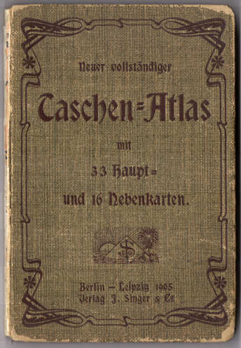
Titel op voorkant band:
Neuer vollständiger Taschen-Atlas
mit 33 Haupt- und 16 Nebenkarten.
Berlin – Leipzig 1905
Verlag J. Singer & Co.
- Deze atlas is een licentie-uitgave van de atlassen (2e reeks) in de Miniatur-Bibliothek van Albert Otto Paul. Hij bevat alle kaarten van de zes atlassen uit die reeks.
Band
De atlas heeft een groene band van calico (gedrukt katoen) van 8,5 × 12,5 cm (B × H). Op de voorkant staan de titel en het logo van de uitgever binnen een decoratief Jugendstil-kader. De achterkant is leeg. De rug ontbreekt bij dit exemplaar. De schutbladen hebben een zich herhalend decoratief patroon.
Inhoud
De atlas heeft een titelpagina, 16 bladzijden met geografische en statistische gegevens, en 33 kaartbladen, elk op 2 bladzijden, met op de achterkanten verdere statistische gegevens van de gebieden die op de kaarten zijn afgebeeld.
De atlas bestaat in feite uit 6 delen met elk een eigen nummering van de bladzijden: de 6 aparte atlassen (2e reeks) in de Miniatur-Bibliothek. Deze delen zijn Duitsland (5 kaarten), Oostenrijk-Hongarije en Zwitserland (6 kaarten) en de werelddelen Europa (7), Azië (5), Afrika en Australië (5) en Amerika (5). Ze bevatten steeds een overzichtskaart en enkele deelkaarten. Zie voor de details de lijst van kaarten, bijkaarten en schaal.
De kaarten zijn uitgevoerd in kleurenlithografie. Ze zijn staatkundig gekleurd (vlakkleur). De bergen zijn op de deelkaarten aangegeven met een zwarte arcering; op de overzichtskaarten wordt geen reliëf getoond. Onderaan de kaarten staan de schaal en een schaalstok.
Vergelijking met de atlassen in de Miniatur-Bibliothek
De kaarten in deze atlas zijn dezelfde als die in de atlassen (2e reeks) in de Miniatur-Bibliothek, inclusief de achterkanten met statistische gegevens. Ze zijn hier gebonden in één band. Verder zijn toegevoegd een titelpagina en 16 bladzijden met geografische en statistische gegevens, die in de atlassen van de Miniatur-Bibliothek niet voorkomen.
Singer, Neuer vollständiger Taschen-Atlas (1905)
- Below is a description of the atlas in keywords. Related pages
- Title description
- Title: Neuer vollständiger Taschen-Atlas
Publisher: J. Singer, Berlin - Leipzig
License: "Verlag für Kunst und Wissenschaft" Albert Otto Paul, Leipzig
Year: 1905 - Title page:
Neuer vollständiger Taschen-Atlas
mit 33 Haupt- und 16 Nebenkarten
sowie erdkundlichen und volkswirtschaftlichen Zahlenaufzeichnungen. Translation:
New and complete Pocket Atlas
with 33 main and 16 inset maps
and also geographical and economical data - Cover title:
Neuer vollständiger Taschen-Atlas
mit 33 Haupt- und 16 Nebenkarten.
Berlin – Leipzig 1905
Verlag J. Singer & Co. - This atlas is a licensed version of the atlases (2nd series) in the Miniatur-Bibliothek from Albert Otto Paul. It contains all the maps of the six atlases from that series.
- Title: Neuer vollständiger Taschen-Atlas
- Binding
- The atlas has a green calico binding measuring 8.5 × 12.5 cm (W × H). On the front cover are title and publisher's logo inside a decorative art nouveau frame. The back cover is empty. The spine is missing from this copy. The endpapers have a decorative repeating pattern.
- Contents
- The atlas has a title page, 16 pages with geographical and statistical data, and 33 double page maps with, on the verso, further statistical data statistical information on the countries depicted on the maps.
- Actually the atlas consists of 6 volumes with each a separate page numbering: the 6 atlases (2nd series) in the Miniatur-Bibliothek. These volumes are Germany (5 maps), Austria-Hungary and Switzerland (6 maps) and the continents Europe (7), Asia (5), Africa and Australia (5) and the Americas (5). Each volume contains a general maps and some regional maps. Details can be found in the list of maps, inset maps and scale.
- The maps have been produced in color lithography. They are colored politically (area color). Mountains on the regional maps are indicated with black hachuring; no relief is shown on the general maps. In the bottom margin are the scale and a linear scale.
- In comparison with the atlases in the Miniatur-Bibliothek
- The maps in this atlas are identical to those in the atlases (2nd series) in the Miniatur-Bibliothek, including the statistical text on the verso. Here they have been bound in one binding. Added are a title page and 16 pages with geographical and statistical data that are absent from the atlases of the Miniatur-Bibliothek.
© M. Witkam, 2012


