Miniatur-Bibliothek, Hand-Atlas 1e reeks (1898-1901)
See below for (a summary of) this text in English.
Hieronder staat de beschrijving van de atlas. Daarbij horen ook de volgende pagina's
Titelgegevens
Titel: Miniatur-Bibliothek, Hand-Atlas
Uitgever: "Verlag für Kunst und Wissenschaft" Albert Otto Paul, Leipzig
Jaar: 1898-1901 (1e reeks)
Titelpagina Hand-Atlas von Deutschland:
Miniatur-Bibliothek 150.
Neuester vollständiger Hand-Atlas des deutschen Reiches und sämtlicher Schutzgebiete
in 16 Karten mit geographischen und statistischen Erläuterungen.
Leipzig Verlag für Kunst und Wissenschaft Albert Otto Paul, Gerberstr. 56
Vertaling:
Miniatuurbibliotheek D. R.-G.-M. 68598 150.
Nieuwste volledige Handatlas van het Duitse Rijk en zijn koloniën
in 16 kaarten met geografische en statistische toelichting.
Leipzig Verlag für Kunst und Wissenschaft Albert Otto Paul, Gerberstr. 56
Omslagtitel Hand-Atlas von Deutschland:
Miniatur-Bibliothek D. R.-G.-M. 68598 150.
Vollständiger Hand-Atlas von Deutschland und den Colonien.
(In 16 Karten mit erläuterndem Text.)
Leipzig, Gerberstr. 56 Verlag für Kunst und Wissenschaft Albert Otto Paul.
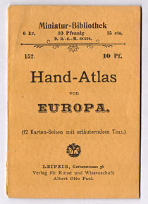
Titelpagina Hand-Atlas von Europa:
Miniatur-Bibliothek D. R.-G.-M. 68598 152.
Neuester vollständiger Hand-Atlas von Europa
(ausser Deutschland Bd. 150 und Oesterreich-Ungarn Bd. 151).
Leipzig Verlag für Kunst und Wissenschaft Albert Otto Paul, Gerberstr. 56
Vertaling:
Miniatuurbibliotheek D. R.-G.-M. 68598 152.
Nieuwste volledige Handatlas van Europa
(behalve Duitsland, deel 150, en Oostenrijk-Hongarije, deel 151)
Leipzig Verlag für Kunst und Wissenschaft Albert Otto Paul, Gerberstr. 56
Omslagtitel Hand-Atlas von Europa:
Miniatur-Bibliothek D. R.-G.-M. 68598 152.
Hand-Atlas von Europa
(12 Karten-Seiten mit erläuterndem Text.)
Leipzig, Gerberstr. 56 Verlag für Kunst und Wissenschaft Albert Otto Paul.
-
Dit is de eerste reeks van atlassen uit de Miniatur-Bibliothek uitgegeven door "Verlag für Kunst und Wissenschaft" Albert Otto Paul. Deze atlassen zijn, met een hoogte van 11,5 cm, iets kleiner dan de latere uitgaven (hoogte 12 cm). Op omslag en titelpagina wordt bij deze reeks ook het adres Gerberstr. 56 van de uitgever vermeld.
Miniatur-Bibliothek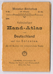
Hand-Atlas von Deutschland, Hand-Atlas von Europa - De reeks atlassen bestaat uit 6 delen (tussen haakjes het nummer in de
Miniatur-Bibliothek en het jaartal)
- Duitsland (150, 1898)
- Oostenrijk-Hongarije, Zwitserland (151, 1899)
- Europa (152, 1899)
- Azië (153, 1901)
- Afrika, Australië (154, 1901)
- Amerika (155, 1901)
- De jaartallen zijn ontleend aan de literatuur. In de atlassen zelf is geen jaar van uitgave te vinden.


Band
De atlassen zijn gebonden in een oranjegele buigzame kartonnen band van 8 × 11,5 cm (B × H). Op de voorkant staat het volgende.
- De tekst "Miniatur-Bibliothek", de prijs in Oostenrijk (6 kr.), Duitsland (10 Pfennig) en Zwitserland (15 cts.), het D. R.-G.-M. nummer 68598 en het nummer in de Miniatur-Bibliothek (150-155)
- De titel en het aantal bladzijden kaarten; de titel kan afwijken van die op de titelpagina
- Het logo van de uitgever
- Naam en adres van de uitgever
Inhoud
De atlassen bestaan uit kaarten met op de achterkant tekst. Het aantal bladzijden tekst is dus steeds gelijk aan het aantal kaartbladzijden. De eerste bladzijde, op de achterkant van de eerste kaart, is steeds de titelpagina. Op de overige tekstbladzijden staan allerlei statistische gegevens van de landen die op de kaarten zijn afgebeeld.
De atlas van Duitsland bevat 8 kaartbladen (van elk twee bladzijden): een overzichtskaart van Noord-Duitsland, 4 detailkaarten van Duitsland en 3 kaartbladen van de Duitse koloniën. Om vergelijking te vereenvoudigen is een beperkt aantal schalen gebruikt. Zie voor de details de inhoudsopgave. Dit deel bevat ook een lijst van de andere uitgaven uit de Miniatuur-Bibliothek. Daarbij staat onder andere de volgende tekst.
150. Neuester vollständiger „Hand-Atlas“
des Deutschen Reiches und sämmtlicher Schutzgebiete. In 16 Karten hochelegant
ausgeführt und mit wichtigen geographischen und statistischen Erläuterungen
versehen. Dieses Werk ist ein litterarisches Ereignis allerersten Ranges.
Wir eröffnen mit dieser No. 150 eine Reihe mit peinlichster Sorgfalt
ausgeführter Atlanten für Schule und Haus. Es folgen hierauf „Oesterreich-Ungarn
und die Schweiz“, ferner: die südlichen Halbinseln, sowie übrigen Staaten
Europas und darauf die anderen Erdteile. Jeder Atlas ist zum Preise von
10 Pfg. zu beziehen und steht derselbe dabei anderen, grösseren Werken in
keiner Beziehung nach.
De atlas van Europa bevat 6 kaartbladen (van elk twee bladzijden): een overzichtskaart van Midden- en Zuid-Europa en 5 kaartbladen voor de landen van Europa; 3 daarvan zijn verdeeld in kleinere kaarten op één bladzijde. Het aantal schalen is beperkt gehouden. Details zijn te vinden in de inhoudsopgave.
De kaarten zijn uitgevoerd in kleurenlithografie. Ze zijn staatkundig gekleurd, in vlakkleur met een smalle bies. Jammer genoeg is de kleur niet nauwkeurig geplaatst. De bergen zijn aangegeven met een zwarte arcering. Onderaan sommige kaarten staat, nauwelijks leesbaar, de tekst "Lith. u. Druck v. Ed. Gaebler's geogr. Inst. Leipzig-N."
Bronnen:
- Aardrijkskunde & Geschiedenis, jaargang 2002, nummer 2 (Overzicht 1e reeks, Hand-Atlas von Deutschland 1910)
- Jürgen Espenhorst: Petermann's Planet, volume II (p. 1300-1301)
Geraadpleegde exemplaren:
- Hand-Atlas von Deutschland (1898)
- Hand-Atlas von Europa (1899)
Miniatur-Bibliothek, Hand-Atlas 1st series (1898-1901)
- Below is a description of the atlas in keywords. Related pages
- Title description
- Title: Miniatur-Bibliothek, Hand-Atlas
Publisher: "Verlag für Kunst und Wissenschaft" Albert Otto Paul, Leipzig
Year: 1898-1901 (1st series) - Title page Hand-Atlas von Deutschland:
Miniatur-Bibliothek D. R.-G.-M. 68598 150.
Neuester vollständiger Hand-Atlas des deutschen Reiches und sämtlicher Schutzgebiete
in 16 Karten mit geographischen und statistischen Erläuterungen.
Leipzig Verlag für Kunst und Wissenschaft Albert Otto Paul, Gerberstr. 56 Translation:
Miniature Library D. R.-G.-M. 68598 150.
Newest complete Hand Atlas of the German Empire and its colonies
in 16 maps with geographical and statistical explanations
Leipzig Verlag für Kunst und Wissenschaft Albert Otto Paul, Gerberstr. 56 - Cover title Hand-Atlas von Deutschland:
Miniatur-Bibliothek D. R.-G.-M. 68598 150.
Vollständiger Hand-Atlas von Deutschland und den Colonien.
(In 16 Karten mit erläuterndem Text.)
Leipzig, Gerberstr. 56 Verlag für Kunst und Wissenschaft Albert Otto Paul. - Title page Hand-Atlas von Europa:
Miniatur-Bibliothek D. R.-G.-M. 68598 152.
Neuester vollständiger Hand-Atlas von Europa:
(ausser Deutschland Bd. 150 und Oesterreich-Ungarn Bd. 151).
Leipzig Verlag für Kunst und Wissenschaft Albert Otto Paul, Gerberstr. 56 Translation:
Miniature Library D. R.-G.-M. 68598 152.
Newest complete Hand Atlas of Europe
(except for Germany, vol. 150, and Austria Hungary, vol. 151)
Leipzig Verlag für Kunst und Wissenschaft Albert Otto Paul, Gerberstr. 56 - Cover title Hand-Atlas von Europa:
Miniatur-Bibliothek D. R.-G.-M. 68598 152.
Hand-Atlas von Europa
(12 Karten-Seiten mit erläuterndem Text.)
Leipzig, Gerberstr. 56 Verlag für Kunst und Wissenschaft Albert Otto Paul. -
This is the first series of atlases from the Miniatur-Bibliothek (Miniature Library) published by "Verlag für Kunst und Wissenschaft" (Publishing House for Art and Science) Albert Otto Paul. With 11.5 cm these atlases are a bit less tall than the later editions (12 cm). On cover and title page of the atlases in this series the address Gerberstr. 56 of the publisher is mentioned.
Miniatur-Bibliothek
Hand-Atlas von Deutschland, Hand-Atlas von Europa - The series consists of 6 volumes (in parentheses the number in the
Miniatur-Bibliothek and the year)
- Germany (150, 1898)
- Austria-Hungary (151, 1899)
- Europe (152, 1899)
- Asia (153, 1901)
- Africa, Australia (154, 1901)
- The Americas (155, 1901)
- The years have been derived from the literature. No publication year is mentioned in the atlases themselves.
- Title: Miniatur-Bibliothek, Hand-Atlas
- Binding
- The atlases are bound in an orange yellow flexible cardboard binding
measuring 8 × 11.5 cm (W × H). The
front cover contains the following information.
- The text "Miniatur-Bibliothek", the price in Austria (6 kr.), Germany (10 Pfennig) and Switzerland (15 cts.), the D. R.-G.-M. number 68598 and the volume number in the Miniatur-Bibliothek (150-155)
- The title and the number of map pages; the title may be different from the one on the title page
- The company logo
- Name and address of the publisher
- The atlases are bound in an orange yellow flexible cardboard binding
measuring 8 × 11.5 cm (W × H). The
front cover contains the following information.
- Contents
- The atlases consist of maps with text on the verso. The number of text pages therefore equals the number of map pages. The first page, verso of the first map, is the title page. The other text pages contain statistical information on the countries depicted on the maps.
- The Atlas of Germany contains 8 map sheets (of 2 pages each): a general map of Northern Germany, 4 regional maps of Germany and map sheets for the German colonies. In order to facilitate comparisons, only a small number of scales have been used. See the table of contents for details. This volume also contains a list of the other volumes in the Miniatur-Bibliothek, which gives the following description of the series.
-
150. Neuester vollständiger „Hand-Atlas“ des Deutschen Reiches und
sämmtlicher Schutzgebiete. In 16 Karten hochelegant ausgeführt und mit
wichtigen geographischen und statistischen Erläuterungen versehen.
Dieses Werk ist ein litterarisches Ereignis allerersten Ranges.
Wir eröffnen mit dieser No. 150 eine Reihe mit peinlichster Sorgfalt ausgeführter Atlanten für Schule und Haus. Es folgen hierauf „Oesterreich-Ungarn und die Schweiz“, ferner: die südlichen Halbinseln, sowie übrigen Staaten Europas und darauf die anderen Erdteile. Jeder Atlas ist zum Preise von 10 Pfg. zu beziehen und steht derselbe dabei anderen, grösseren Werken in keiner Beziehung nach. - The Atlas of Europe contains 6 map sheets (of 2 pages each): a general map of Central and Southern Europe and 5 map sheets for the countries in Europe; three of them are divided in smaller maps on one page. A small number of scales are used. Details can be found in the table of contents.
- The maps have been produced in color lithography. They are colored politically, in area color with a narrow edging. Unfortunately the colors have not been positioned correctly. Mountains are indicated with a black hachuring. In the bottom margin of some maps, hardly legible, is the text "Lith. u. Druck v. Ed. Gaebler's geogr. Inst. Leipzig-N." (lithography and engraving by Ed. Gaeblers Geographical Institute in Leipzig).
- Sources:
- Aardrijkskunde & Geschiedenis, year 2002, number 2 (Overview of 1st series, Hand-Atlas von Deutschland 1910) in Dutch
- Jürgen Espenhorst: Petermann's Planet, volume II (p. 1300-1301)
- Copies consulted:
- Hand-Atlas von Deutschland (1898)
- Hand-Atlas von Europa (1899)
© M. Witkam, 2012
![]()
![]()