Hand- und Schulatlas, V.F. Klun, 2e druk (1869)
See below for (a summary of) this text in English.
Hieronder staat de beschrijving van de atlas. Daarbij horen ook de volgende pagina's
Titelgegevens
Titel: Hand- und Schulatlas, V.F. Klun / Klun's Schulatlas
Uitgever: Herder, Freiburg im Breisgau
Jaar: 1869 (2e druk)
Titelpagina:
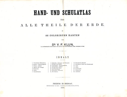
Hand- und Schulatlas über alle Theile der Erde.
In 22 colorirten Karten von Dr. V.F. Klun,
k.k. Sectionsrath im Ministerium für Handel und Volkswirthschaft, emer. Professor in Wien.
Inhalt ...
Freiburg im Breisgau. Herder'sche Verlagsbuchhandlung. 1869
Vertaling:
Hand- en schoolatlas van de gehele aarde.
In 22 gekleurde kaarten, door dr. V.F. Klun,
Afdelingsadviseur bij het Ministerie van Handel en Economie, emeritus hoogleraar te Wenen.
Inhoud ...
Uitgeversmaatschappij Herder, Freiburg im Breisgau. 1869
- Dit is de 2e druk van de atlas. De 1e druk verscheen ook in 1869, maar dan met ongevouwen kaarten (45 × 35 cm). Dat formaat zal voor een schoolboek niet erg handig geweest zijn.
Band
De atlas heeft een kartonnen band van 24 × 35,5 cm (B × H) en een linnen rug. Op de voorkant staan alle gegevens die ook op de titelpagina voorkomen: de volledige titel en de inhoudsopgave.
Inhoud
De atlas bevat een titelblad en 22 kaartbladen, elk op van 2 pagina's; zie de inhoudsopgave. De kaarten zijn vervaardigd in lithografie (steendruk) en met de hand gekleurd, meestal in randkleur. De druk van de kaarten is voor lithografie ongewoon scherp.
Op de kaarten staat steeds "Klun's Schulatlas Nº ..." (rechtsboven op de 'liggende' bladen en in de rechtermarge op de 'staande'). Onderaan in het midden staat de tekst "Verlag von B. Herder in Freiburg i/ Baden". Op enkele kaarten wordt J. Brack (of Brach) genoemd als graveur van de berggebieden.
Na de wereldkaart, met verschillende projecties van de wereldbol, komen 16 kaarten van Europa en de Europese landen en tenslotte 5 kaarten van de werelddelen Azië, Afrika, Noord-Amerika, Zuid-Amerika en Australië. Bij de Europese landen ligt de nadruk op Midden-Europa (Duitsland, Oostenrijk, Zwitserland) met 6 kaartbladen.
Op bijna alle kaarten staat de schaal aangegeven, meestal als een 'rond' getal; zie voor de details de lijst van kaarten, bijkaarten en schaal. Op veel kaarten is ook een bergprofiel getekend, ter verduidelijking van het met arcering aangegeven reliëf; zie ook de lijst van bergprofielen.
Hand- und Schulatlas, V.F. Klun, 2nd edition (1869)
- Below is a description of the atlas in keywords. Related pages
- Title description
- Title: Hand- und Schulatlas, V.F. Klun / Klun's Schulatlas
Publisher: Herder, Freiburg im Breisgau
Year: 1869 (2nd edition) - Title page:
Hand- und Schulatlas über alle Theile der Erde.
In 22 colorirten Karten von Dr. V.F. Klun,
k.k. Sectionsrath im Ministerium für Handel und Volkswirthschaft, emer. Professor in Wien.
Inhalt ...
Freiburg im Breisgau. Herder'sche Verlagsbuchhandlung. 1869 Translation:
Hand and School Atlas of the World
In 22 colored maps, by dr. V.F. Klun,
Section Counsellor of the Ministry of Commerce and Economy, emeritus Professor in Vienna.
Contents ...
Freiburg im Breisgau. Herder Publishing Company. 1869 - This is the 2nd edition of the atlas. The 1st edition was also published in 1869, but with unfolded maps (45 × 35 cm). It must have had a rather awkward size for a school book.
- Title: Hand- und Schulatlas, V.F. Klun / Klun's Schulatlas
- Binding
- The atlas has a cardboard binding of size of 24 × 35.5 cm (W × H) with a cloth spine. On the front cover is the same information as on the title page: full title and table of contents.
- Contents
- The atlas has a title page and 22 map sheets, all of them on double pages; see the table of contents. The maps are produced in lithography and colored by hand, usually in outline. For lithography the printing of the maps is unusually clear.
- On every map is the text "Klun's Schul Atlas Nº ..." (in the upper right on landscape sheets and in the right margin on portrait ones). In the center of the lower margin is the text "Verlag von B. Herder, Freiburg i/ Baden". On a few maps the name J. Brack (or Brach) is mentioned as the engraver of the mountain regions.
- The world map, with several projections of the globe, is followed by 16 maps of Europe and the European countries. Thereafter are 5 maps of the other continents: Asia, Africa, North America, South America and Australia. The emphasis is on Central Europe (Germany, Austria, Switzerland) with 6 map sheets.
- The scale is given on most maps, usually as a 'round' number; details can be found in the list of maps, inset maps and scale. On many maps there is also a mountain profile, to clarify the relief indicated by hachuring; see the list of mountain profiles.
© M. Witkam, 2009


