Weimarer Hand- und Reisekarten (ca. 1872-1902)
See below for (a summary of) this text in English.
Hieronder staat de beschrijving van de kaartserie. Daarbij horen ook de volgende pagina's
Titelgegevens
Titel: (Weimarer) Hand- und Reisekarten, Hand- und Eisenbahnkarten,
Thüringer Touristen-Karten
Uitgever: Geographisches Institut,
Weimar (und Wien)
Jaar: ca. 1872-1902
Omslag van kaart 34. Ober- u. Mittel-Italien (1873):
Weimar, Geographisches Institut
Hand- und Eisenbahnkarte von Ober- u. Mittel-Italien
Carton: Umgebung von Rom
Nº 34 VI. Auflage 1873.
Bearbeitet von H. Kiepert 1:1,200 000 d. nat. Gr.
Preis 15 Sgr.
Vertaling:
Weimar, Geographisches Institut
Hand- en spoorwegkaart van Noord- en Midden-Italië
Bijkaart: Rome en omgeving
Nº 34 6e druk 1873.
Bewerkt door H. Kiepert schaal 1:1.200.000
Prijs: 15 Silbergroschen
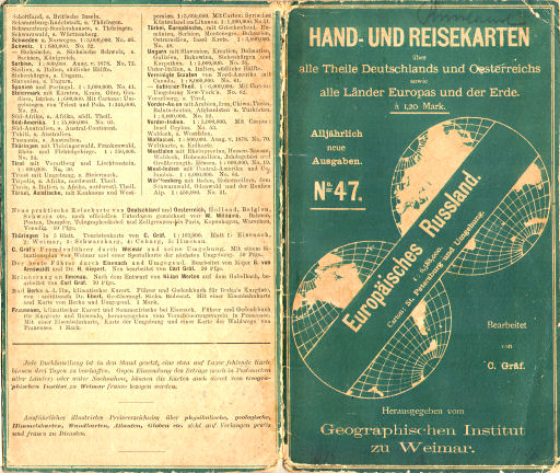
Omslag van kaart 47. Europäisches Russland (1881):
Hand- und Reisekarten
über alle Theile Deutschlands und Oesterreichs sowie alle Länder Europas und der Erde.
à 1,20 Mark
Alljährlich neue Ausgaben.
Nº 47. Europäisches Russland. 1:6,588,000
Carton: St. Petersburg und Umgebung.
Bearbeitet von C. Gräf.
Herausgegeben vom Geographischen Institut zu Weimar.
Vertaling:
Hand- en reiskaarten
van alle delen van Duitsland en Oostenrijk evenals van alle landen van Europa en de rest van de wereld.
Prijs: 1,20 mark
Jaarlijks nieuwe uitgaven.
Nº 47. Europees Rusland. schaal 1:6.588.000
Bijkaart: St. Petersburg en omgeving.
Bewerkt door C. Gräf.
Uitgegeven door het Geographische Institut in Weimar.
Omslag van kaart 83.4. Koburg (ca. 1892):
Gräf's Thüringer Touristen-Karten
herausgegeben von J.I. Kettler.
Blatt 4. Koburg
Sonneberg, Lauscha, Unter-Neubrunn, Schleusingen, Römhild, Lind.-Friedrichshall.
Preis jeder Karte 75 Pfennig.
Maßstab 1:100 000
Alljährlich neue Ausgaben.
Geographisches Institut zu Weimar und Wien.
Vertaling:
Gräf's Toeristenkaarten van Thüringen
onder redactie van J.I. Kettler.
Blad 4. Koburg
Sonneberg, Lauscha, Unter-Neubrunn, Schleusingen, Römhild, Lind.-Friedrichshall.
Prijs per kaart 75 Pfennig.
Schaal 1:100.000
Jaarlijks nieuwe uitgaven.
Geographisches Institut in Weimar en Wenen.
-
De kaarten hebben verschillende titels op het omslag. De lijsten met leverbare kaarten in de verschillende omslagen zijn bijna gelijk. De oorsprong van de meeste kaarten – de Hand-Atlas des Himmels und der Erde van het Geographische Institut in Weimar – is ook steeds dezelfde. Daarom beschouw ik de verschillende kaarten als behorend tot één reeks.
 Hand- und Reisekarte
47. Europäisches Russland (1881)
Europees Rusland, buitenkant omslag (21,5 × 18 cm) - In de lijst met kaarten worden onder andere genoemd de kaart van Thüringen in 5 bladen (Nº 83) en de losse kaarten van Weimar (Nº 82), Eisenach (Nº 84) en Ilmenau (Nº 85). In dezelfde periode verschenen ook de 'Thüringer Touristen-Karten', met de 5 bladen Eisenach, Weimar, Schwarzburg, Koburg en Ilmenau. Ik heb aangenomen dat de kaart van Thüringen in 5 bladen identiek is aan de 'Thüringer Touristen-Karten' en dat de genoemde losse kaarten deel uitmaken van die serie.
- De datering van kaarten is niet helemaal zeker. Ik kom op de periode
1872-1902 om de volgende redenen.
- Sommige kaarten en omslagen zijn van een jaartal voorzien. Het oudste jaar dat ik op een omslag heb kunnen vinden, is 1873.
- Op enkele kaarten wordt als vestigingsplaats van het Geographische Institut ook Wenen genoemd. Dat is het gevolg van een samenwerking, vanaf ongeveer 1892, met uitgeverij Hölzel in Wenen. Kaarten met die aanduiding moeten dus vanaf 1892 verschenen zijn.
- In de 10e jaargang (1901) van de Bibliotheca Geographica worden de kaarten nog genoemd met de toevoeging 'Auflage 1901' (uitgave 1901).
De kaarten
Deze kaartserie bestaat uit losse kaarten van de Hand-Atlas des Himmels und der Erde (45e-49e druk) aangevuld met kaarten van onder andere Oost-Europa en enkele regionale kaarten van Thüringen en Saksen. Zie voor het overzicht de lijst van kaarten en schaal.
Oorspronkelijk werden de kaarten, net als die in de Hand-Atlas, vervaardigd in koperdruk en met de hand gekleurd. Vanaf ongeveer 1875 zijn ze gemaakt in kleurenlithografie. Op de kaarten in mijn verzameling staan de cartografen vermeld: H. Kiepert, C. Gräf en C. Riemer. Soms is ook de naam van de graveur vermeld.
De kaarten zijn meestal voorzien van een omslag: zie de pagina met plaatjes. Bij de vroege uitgaven worden daarop ook vaak de andere kaarten uit de reeks genoemd, evenals de overige cartografische uitgaven van het Geographische Institut. De omslagen van de latere uitgaven zijn veel soberder, met een motief van vliegende zwaluwen. Vaak wordt op het omslag vermeld dat er jaarlijks een nieuwe uitgave van de kaarten verschijnt.
Vergelijking met de Hand-Atlas (45e-49e druk)
De meeste kaarten uit deze reeks komen uit de Hand-Atlas des Himmels und der Erde. De nummers van deze kaarten zijn gelijk aan die in de Hand-Atlas. De overige kaarten in de reeks zijn van gebieden in Oost-Europa, van Palestina en van delen van Thüringen en Saksen. Niet alle kaarten uit de Hand-Atlas zijn in deze reeks opgenomen. De sterrenkundige en natuurkundige kaarten ontbreken, evenals de deelkaarten van Frankrijk.
Zie verder de vergelijkende tabellen
- Vergelijking van Handkarten met Hand-Atlas
- Vergelijking van Hand-Atlas met Handkarten
Bron:
- Arnhold: Das Geographische Institut zu Weimar (blz. 33, 83)
Weimarer Hand- und Reisekarten (ca. 1872-1902)
- Below is a description of the map series in keywords. Related pages
- Title description
- Title: (Weimarer) Hand- und Reisekarten, Hand- und Eisenbahnkarten,
Thüringer Touristen-Karten
Publisher: Geographisches Institut, Weimar (und Wien)
Year: ca. 1872-1902 - Cover of sheet 34. Ober- u. Mittel-Italien (1873):
Weimar, Geographisches Institut
Hand- und Eisenbahnkarte von Ober- u. Mittel-Italien
Carton: Umgebung von Rom
Nº 34 VI. Auflage 1873.
Bearbeitet von H. Kiepert 1:1,200 000 d. nat. Gr.
Preis 15 Sgr. Translation:
Weimar, Geographisches Institut
Hand and railroad map of North and Central Italy
Inset map: Rome and environs.
Nº 34 6th edition 1873.
Edited by H. Kiepert scale 1:1,200,000
Price: 15 Silbergroschen - Cover of sheet 47. Europäisches Russland (1881):
Hand- und Reisekarten
über alle Theile Deutschlands und Oesterreichs sowie alle Länder Europas und der Erde.
à 1,20 Mark
Alljährlich neue Ausgaben.
Nº 47. Europäisches Russland. 1:6,588,000
Carton: St. Petersburg und Umgebung.
Bearbeitet von C. Gräf.
Herausgegeben vom Geographischen Institut zu Weimar. Translation:
Hand and travel maps
of all parts of Germany and Austria as well as all the countries in Europe and the rest of the world
Price: 1.20 marks
New editions every year.
Nº 47. Ruslsia in Europe. scale 1:6,588,000
Inset map: St. Petersburg and environs.
Edited by C. Gräf.
Published by the Geographische Institut in Weimar. - Cover of sheet 83.4. Koburg (ca. 1892):
Gräf's Thüringer Touristen-Karten
herausgegeben von J.I. Kettler.
Blatt 4. Koburg
Sonneberg, Lauscha, Unter-Neubrunn, Schleusingen, Römhild, Lind.-Friedrichshall.
Preis jeder Karte 75 Pfennig.
Maßstab 1:100 000
Alljährlich neue Ausgaben.
Geographisches Institut zu Weimar und Wien. Translation:
Gräf's Tourist maps of Thuringia
edited by J.I. Kettler.
Sheet 4. Koburg
Sonneberg, Lauscha, Unter-Neubrunn, Schleusingen, Römhild, Lind.-Friedrichshall.
Price of each map: 75 Pfennig.
Scale 1:100,000
New editions every year.
Geographisches Institut in Weimar and Vienna. -
Several different titles are mentioned on the covers of the maps. The list of available maps on the covers is almost the same though. The origin of most maps – the Hand-Atlas des Himmels und der Erde from the Geographische Institut in Weimar – is also identical. For this reason I consider these differently named maps as belonging to one series.
Hand- und Reisekarte
47. Europäisches Russland (1881)
Russia in Europe, outside cover (21.5 × 18 cm) - One of the listed maps is Thuringia in 5 sheets (Nº 83). There are also separate maps of Weimar (Nº 82), Eisenach (Nº 84) and Ilmenau (Nº 85). In the same period the 'Thüringer Touristen-Karten' were published in 5 sheets: Eisenach, Weimar, Schwarzburg, Koburg and Ilmenau. I assume that the map of Thuringia in 5 sheets is identical to the 'Thüringer Touristen-Karten' and that the separate maps are part of that series.
- The date of the maps is uncertain. My assumption of the period
1872-1902 is based on the following observations.
- On some maps and covers a year is mentioned. The earliest year I have found on a cover is 1873.
- The publisher location mentioned is sometimes also Vienna, because from about 1892 the GI cooperated with Hölzel publishers in Vienna. Maps with this location must therefore have been published in 1892 or later.
- In the 10th volume (1901) of Bibliotheca Geographica the maps are still mentioned with the addition 'Auflage 1901' (1901 edition).
- Title: (Weimarer) Hand- und Reisekarten, Hand- und Eisenbahnkarten,
Thüringer Touristen-Karten
- The maps
- The map series consists of separate maps from the Hand-Atlas des Himmels und der Erde (45th-49th editions) with some additional maps of Eastern Europe and regional maps of Thuringia and Saxony. See also the list of maps and scale.
- Originally the maps were produced in copper engraving and hand colored. From around 1875 they were made in color lithography. On the maps in my collection the cartographers are mentioned: H. Kiepert, C. Gräf and C. Riemer. On some maps there is also the name of the engraver.
- Most maps have a cover: see the pictures page. The early editions usually give lists of the maps from the series and the other cartographic publications from the Geographische Institut. The later editions are more austere, with a design of flying swallows. It often says 'new editions every year'.
- In comparison with the Hand-Atlas (45th-49th editions)
- Most maps in this series originate from the Hand-Atlas des Himmels und der Erde. The numbers in this map series and the ones in the Hand-Atlas are identical. The remaining maps are of regions in Eastern Europe, Palestine and parts of Thuringia and Saxony. Not all the maps from the Hand-Atlas have been incorporated in this series. The astronomical and physical maps are missing as well as the regional maps of France.
- Details can be found in the comparison tables
Source:
- Arnhold: Das Geographische Institut zu Weimar (p. 33, 83)
© M. Witkam, 2010
![]()
![]()