Perthes' Taschen-Atlas vom Deutschen Reich, 1e-6e druk (1907-1922)
See below for (a summary of) this text in English.
Hieronder staat de beschrijving van de atlas. Daarbij horen ook de volgende pagina's
- Plaatjes van de atlas
- Tabellen en lijsten bij de atlas
- Vergelijking met Stielers Hand-Atlas (1907)
en ook
Titelgegevens
Titel: Taschen-Atlas vom Deutschen Reich
Uitgever: Justus Perthes, Gotha
Jaar: 1907-1922 (1e-6e druk)
Titelpagina (2e druk, 1908):
Justus Perthes' Taschen-Atlas vom Deutschen Reich
Bearbeitet von Hermann Habenicht
24 kolorierte Karten in Kupferstich mit Namenverzeichnis
Geographisch-statistische Notizen von Hugo Wichmann
Zweite Auflage
Gotha: Justus Perthes 1908
Vertaling:
Justus Perthes' Zakatlas van het Duitse Rijk
Bewerkt door Hermann Habenicht
24 gekleurde kaarten in kopergravure met een register
Geografisch-statistische aantekeningen door Hugo Wichmann
Tweede druk
Gotha, Justus Perthes 1908
-
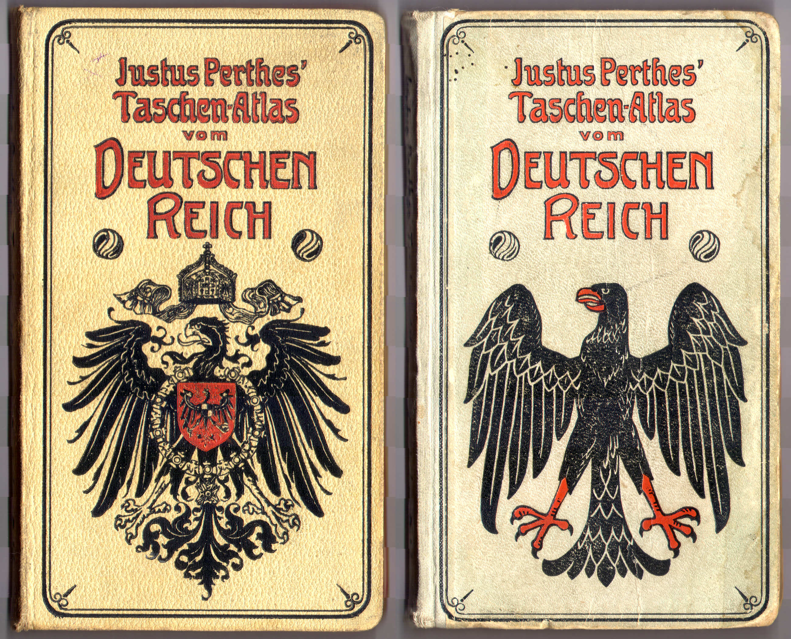
Dit is de eerste reeks van zakatlassen van Duitsland van Justus Perthes. Kenmerkend voor deze reeks is de decoratieve voorkant van de band, met de rijksadelaar – de uitgave 1922 met de 'republikeinse' adelaar – en de titel
 Perthes' Taschen-Atlas vom Deutschen Reich
Voorkant banden 1908, 1922- Justus Perthes' Taschen-Atlas vom Deutschen Reich
- Naast deze Atlas van Duitsland verschenen bij Justus Perthes in dezelfde periode nog een aantal zakatlassen.
- Redacteur van de atlas is Hermann Habenicht (1844-1917), in dezelfde periode ook verantwoordelijk voor de Taschen-Atlas (zakatlas van de wereld) en de See-Atlas (zeeatlas in zakformaat).
- De kaarten op de schaal 1:1.500.000 zijn afgeleid van de kaart van Duitsland in 4 bladen, van Carl Vogel (1828-1897), uit de 9e druk van Stielers Hand-Atlas. De detailkaarten op de schaal 1:500.000 zijn gebaseerd op Vogels Karte des Deutschen Reichs.
- De geografische en statistische aantekeningen zijn samengesteld door Hugo Wichmann (1852-1932).
Band
De atlas heeft een witte of beige band van 'calico' (gedrukt katoen). Op de voorkant staat de rijksadelaar – bij de uitgave 1922 de 'republikeinse' adelaar – en de titel. Op de achterkant staat soms de tekst "abwaschbar" (afwasbaar) of "Justus Perthes' Buchbinderei" (Justus Perthes' boekbinderij). De titel staat ook op de rug. Op de schutbladen staat de bladwijzer en reclame voor andere geografische uitgaven van Justus Perthes zoals de andere zakatlassen en Stielers Hand-Atlas.
Inhoud
Aan de binnenkant van de band staat de bladwijzer van de atlas. Daarna komen de titelpagina, 1 bladzijde inhoudopgave en 2 bladzijden voorwoord. Het geografisch-statistische deel heeft 16 bladzijden en het plaatsnamenregister 75 of 76. Tenslotte zijn er de 24 kaarten (op 2 pagina's) van 19,5 × 17 cm, in kleur, enkelzijdig gedrukt op steviger papier dan dat van de tekstpagina's.
Van de 24 kaarten zijn er 19 voor de verschillende delen van Duitsland op de schaal 1:1.500.000. De uitsnede daarvan sluit zo goed mogelijk aan bij de staatkundige indeling. Verder zijn er 5 detailkaarten van enkele toeristische gebieden op de schaal 1:500.000. Zie voor de details de lijst van kaarten, bijkaarten en schaal.
De 19 'hoofdkaarten' bestaan uit delen van de kaart van Duitsland in 4 bladen van Carl Vogel uit de 9e druk van Stielers Hand-Atlas (kaartbladen 9-12). Deze atlas verscheen in de periode 1905-1924. De 5 detailkaarten geven enkele toeristische gebieden weer: het dal van de Rijn, de Harz, het Thüringerwoud, het Reuzengebergte en de Beierse Alpen. Deze kaarten bestaan uit delen van 'Vogels Karte des Deutschen Reichs', een kaart van Duitsland in 27 bladen.
De kaarten zijn vervaardigd in kopergravure en lithografisch gedrukt. Bovenaan de kaart staan steeds de naam van het blad, de titel van de atlas en het nummer van de kaart. Onderaan staan de schaal, de tekst "Gotha: Justus Perthes" en een schaalstok. In de marge staan letters (verticaal) en cijfers (horizontaal) om met behulp van het register de namen op de kaart te kunnen vinden.
In de 1e tot en met de 5e druk (1907-1914) zijn de grenzen per deelstaat verschillend gekleurd. Het reliëf wordt in zwarte arcering aangegeven. Rivieren zijn zwart, meren en zeeën blauw, spoorwegen rood (hoofdlijnen) of oranje (secundaire lijnen). Op de detailkaarten van toeristische gebieden is alleen het reliëf aangegeven; bredere rivieren zijn daar blauw gekleurd.
In de 6e druk (1922) is het kleurenschema anders. De grenzen van de staatkundige eenheden zijn daar alleen groen gekleurd. Het reliëf wordt in bruine arcering aangegeven. Spoorwegen zijn alleen rood, dik voor hoofdlijnen en dun voor secundaire lijnen. Dit kleurenschema is hetzelfde als bij de latere drukken.
Uitgaven
In de periode 1907-1914 zijn de 1e tot en met de 5e druk van de atlas verschenen; zie ook de lijst met uitgaven. De indeling van de atlas is in die periode niet veranderd. De kaarten zijn regelmatig geactualiseerd.
De 6e druk verscheen in 1922. Deze wijkt af van de eerdere uitgaven. Hierboven is al het andere kleurenschema genoemd. Ook de band is anders, met een 'republikeinse' in plaats van een 'keizerlijke' adelaar. Verder is natuurlijk de naoorlogse situatie weergegeven. De kaarten zijn dezelfde als in de eerdere uitgaven, maar sommige gebieden liggen niet meer in Duitsland. Dat geldt bijvoorbeeld voor Elzas-Lotharingen en grote delen van de voormalige provincies West-Pruisen en Posen. Op die kaarten zijn nog steeds de Duitse namen gebruikt. Dit is overigens ook in de latere uitgaven zo gedaan.
Cartografisch lijkt de 6e druk meer op de latere drukken dan op de 1e tot en met de 5e druk. Vanwege de overeenkomsten in band, auteurs en omvang van de aantekeningen en het register is de 6e druk toch in deze reeks uitgave ingedeeld.
Vergelijking met de kaarten van Carl Vogel in Stielers Hand-Atlas
De kaarten op de schaal 1:1.500.000 in deze Taschen-Atlas zijn in principe uitsneden uit de kaart van Duitsland in 4 bladen, van Carl Vogel, uit de 9e druk van Stielers Hand-Atlas. Daarbij zijn – in de 1e-5e druk van de Taschen-Atlas – onder andere de volgende wijzigingen aangebracht.
- De bergen zijn in de Taschen-Atlas zwart gearceerd en in Stielers Hand-Atlas bruin.
- De spoorwegen zijn hier duidelijker aangegeven, in twee verschillende kleuren.
- De kaarten zijn soms iets gedraaid. In Stielers Hand-Atlas wijkt het werkelijke noorden aan de randen van de kaart nogal af van het kaartnoorden, en dat is in de Taschen-Atlas gecorrigeerd.
Zie ook de pagina met plaatjes van beide kaartwerken ter vergelijking naast elkaar.
Perthes' Taschen-Atlas vom Deutschen Reich, 1st-6th editions (1907-1922)
- Below is a description of the atlas in keywords. Related pages
- Pictures of the atlas
- Tables and lists to the atlas
- Comparison with Stielers Hand-Atlas (1907)
- and also
- Title description
- Title: Taschen-Atlas vom Deutschen Reich
Publisher: Justus Perthes, Gotha
Year: 1907-1922 (1st-6th editions) - Title page:
Justus Perthes' Taschen-Atlas vom Deutschen Reich
Bearbeitet von Hermann Habenicht
24 kolorierte Karten in Kupferstich mit Namenverzeichnis
Geographisch-statistische Notizen von Hugo Wichmann
Zweite Auflage
Gotha: Justus Perthes 1908 Translation:
Justus Perthes Pocket Atlas of the German Empire
Edited by Hermann Habenicht
24 colored maps in copper engraving with an index
Geographical and statistical notes by Hugo Wichmann
Second edition
Gotha, Justus Perthes 1908 -
This is the first series of pocket atlases of Germany from Justus Perthes. The atlases of this series are characterized by their decorative cover, with the imperial eagle – the 1922 edition with the 'republican eagle' – and the title
Perthes' Taschen-Atlas vom Deutschen Reich
Front covers 1908, 1922- Justus Perthes' Taschen-Atlas vom Deutschen Reich
- Complementary to this Atlas of Germany several other pocket atlases were published by Justus Perthes in the same period.
- Editor of the atlas is Hermann Habenicht (1844-1917), in the same period also responsible for the Taschen-Atlas (pocket size world atlas) and the See-Atlas (pocket size sea atlas).
- The maps at the scale of 1:1,500,000 were derived from the map of Germany in 4 sheets, by Carl Vogel (1828-1897), in the 9th edition of Stielers Hand-Atlas. The regional maps at 1:500,000 are based on Vogel Karte des Deutschen Reichs.
- The geographical and statistical notes are compiled by Hugo Wichmann (1852-1932).
- Title: Taschen-Atlas vom Deutschen Reich
- Binding
- The atlas has a white or beige calico binding. On the front cover is the imperial eagle – the 1922 edition has a 'republican' eagle – and the title. On the back cover is sometimes the text "abwaschbar" (washable) or "Justus Perthes' Buchbinderei" (Justus Perthes' Bindery). The title is also on the spine. On the endpapers is the sheet index and advertisement for other geographical publications from Justus Perthes such as the other pocket atlases and Stielers Hand-Atlas.
- Contents
- In the inside front cover is the sheet index of the atlas. Thereafter are title page, table of contents (1 page) and preface (2 pages). The geographical and statistical section has 16 pages and the place name index 75 or 76. In the end are the 24 maps (double page) measuring 19.5 × 17 cm, in color, printed on one side only on more solid paper that the text pages.
- There are 19 maps of the different regions of Germany at a scale of 1:1,500,000. Their cut-out follows the political subdivision. The other 5 maps depict several touristic regions at a scale of 1:500,000. Details can be found in the list of maps, inset maps and scale.
- The 19 'main maps' are composed from parts of the map of Germany in 4 sheets by Carl Vogel from the 9th edition of Stielers Hand-Atlas (map sheets 9-12). This atlas was published in the 1905-1924 period. The 5 regional maps depict some touristic regions: the Rhine valley, the Harz, the Thuringian Forest, the Giant Mountains and the Bavarian Alps. These maps consist of parts of 'Vogels Karte des Deutschen Reichs', a map of Germany in 27 sheets.
- The maps have been produced in copper engraving and were printed lithographically. In the upper margin of the maps are the sheet name, the atlas title and the sheet number. In the lower margin are the scale of the map, the text "Gotha: Justus Perthes" and a linear scale. In the margin of the maps are letters (vertically) and digits (horizontally) to facilitate finding names on the map with the index.
- In the 1st through 5th editions (1907-1914) the outlines of the states are printed in several colors. The relief is indicated with black hachuring. Rivers are black, lakes and seas blue, railroads red (main lines) or orange (secondary lines). On the detailed maps of touristic regions only the relief is indicated, and larger rivers are colored blue.
- The 6th edition (1922) has a different color scheme. The borders of the political entities are colored green only. The relief is indicated with brown hachuring. Railroads are only red, thick for main lines and thin for secondary lines. This color scheme is maintained in later editions.
- Editions
- In the 1907-1914 period, the 1st through 5th editions of the atlas were published; see the list of editions. The design of the atlas has not changed in those years. The maps were updated on a regular basis.
- The 6th edition was published in 1922. It differs from the earlier editions. As mentioned above the color scheme has changed. The binding is also different, with a 'republican' instead of an 'imperial' eagle. Of course the postwar situation is depicted. The maps have remained the same but some regions don't belong to Germany any more. This is especially true for Alsace-Lorrain and major parts of the former provinces of West Prussia and Posen. On those maps the German names are still in use. This was also practiced in later editions.
- Cartographically the 6th edition looks more like the later editions than like the 1st through 5th. Because of the similarity in binding, authors and number of pages of notes and index, the 6th edition has still been classified with this series.
- Comparison with the Carl Vogel maps in Stielers Hand-Atlas
- The maps at the scale of 1:1,500,000 in this Taschen-Atlas are
actually cut-outs from the maps of Germany in 4 sheets, by Carl Vogel,
from the 9th edition of Stielers
Hand-Atlas. Several changes have been made – in the 1st-5th editions
of the Taschen-Atlas.
- The mountain hachuring is black in the Taschen-Atlas and brown in Stielers Hand-Atlas
- Railways are indicated more clearly, in two different colors
- The maps sometimes have been rotated slightly. In Stielers Hand-Atlas the map north deviates from the geographical north, especially in the left and right portions of the composed map. This was corrected in the Taschen-Atlas.
- The maps at the scale of 1:1,500,000 in this Taschen-Atlas are
actually cut-outs from the maps of Germany in 4 sheets, by Carl Vogel,
from the 9th edition of Stielers
Hand-Atlas. Several changes have been made – in the 1st-5th editions
of the Taschen-Atlas.
© M. Witkam, 2011
![]()
![]()