Grimm, Atlas (1836)
See below for (a summary of) this text in English.
Hieronder staat de beschrijving van de atlas. Daarbij horen ook de volgende pagina's
Titelgegevens
Titel: Grimm, Atlas
Uitgever: Simon Schropp & Co., Berlijn
Jaar: 1836
Titelpagina (1e aflevering):
Atlas.
Entworfen und gezeichnet von J.L. Grimm.
1. Lieferung von sechs Karten.
Berlin, bei Simon Schropp & Comp. 1833
Vertaling:
Atlas.
Ontworpen en getekend door J.L. Grimm.
1e aflevering van zes kaarten.
Berlijn, Simon Schropp & Comp. 1833
Met dank aan AtlasBase (DAC-01.0000.0031)
- Dit is de enige uitgave van de wereldatlas van Julius Ludwig Grimm (1806-1834). Grimm heeft zelf 12 van de 20 kaarten getekend. De andere 8 zijn na zijn overlijden gemaakt. De datering van de atlas is gebaseerd op de jaartallen, 1830-1836, die op de kaarten worden vermeld.
Band
Dit exemplaar is gebonden in een nieuwe band met afmetingen 30,5 × 38,5 cm (H × B). Op de voorkant is een oud etiket geplakt; de tekst daarop is slecht leesbaar. Verschillende kaarten (29,5 × 37 cm) hebben een verticale vouw op ongeveer 9 cm van de rechterzijkant. Ze zijn ongevouwen ingebonden.
Inhoud
De atlas heeft geen titelpagina. De hier gebruikte titel 'Atlas' is ontleend aan de titel van de 1e aflevering, aanwezig in het exemplaar van de Staatsbibliothek in Berlijn; zie ook de pagina met plaatjes. De atlas bevat 20 kaarten. Er is geen inhoudsopgave of register.
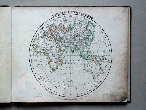
Omdat de inhoudsopgave ontbreekt, is niet na te gaan of de 20 kaarten in dit exemplaar in de juiste volgorde zijn ingebonden. Hier begint de atlas met 2 kaarten van het oostelijk en westelijk halfrond. Daarna komen 6 kaarten van de werelddelen, en tenslotte zijn er 12 kaarten van de landen in Europa. Er zijn dus geen kaarten van afzonderlijke landen of gebieden buiten Europa.
De meeste kaarten zijn vervaardigd in kopergravure, maar op drie ervan (Australië, Italië, Duitsland), gegraveerd door W. Scharrer, staat de vermelding "in Stein gestochen", dus in lithografie. Ze zijn meestal staatkundig gekleurd (randkleur met bies), maar op de kaart van Zwitserland zijn de taalgebieden aangegeven. De naam van de kaart staat meestal in de bovenmarge.
In de benedenmarge staat de naam van de uitgever Simon Schropp en het jaartal. Op 12 kaarten staat er ook de naam van de tekenaar J.L. Grimm (of I.L. Grimm). Op 18 kaarten de naam van de graveur(s), onder anderen 7 keer S. Siebert. Zie ook het overzicht. Er kan een schaalstok staan en andere gegevens, zoals de gebruikte afkortingen. De overige informatie staat binnen het kaartkader. Op 11 kaarten wordt de schaal vermeld.
Grimm, Atlas (1836)
- Below is a description of the atlas in keywords. Related pages
- Title description
- Title: Grimm, Atlas
Publisher: Simon Schropp & Co., Berlin
Year: 1836 - Title page (1st installment):
Atlas.
Entworfen und gezeichnet von J.L. Grimm.
1. Lieferung von sechs Karten.
Berlin, bei Simon Schropp & Comp. 1833 Translation:
Atlas.
Designed and drawn by J.L. Grimm.
1st installment in six maps.
Berlin, bei Simon Schropp & Comp. 1833 - Courtesy of: AtlasBase (DAC-01.0000.0031)
- This is the only edition of the world atlas by Julius Ludwig Grimm (1806-1834). Grimm has drawn 12 of the 20 maps himself. The other 8 maps were made after his death. The year 1836 of the atlas is based on the years, 1830-1836, on the maps.
- Title: Grimm, Atlas
- Binding
- This copy is bound in a modern binding measuring 30.5 × 38.5 cm (H × W). On the front cover an old label is pasted with a hardly legible text. Many maps (29,5 × 37 cm) have a vertical fold at some 9 cm from the right edge. They have been bound unfolded.
- Contents
- The atlas has no title page. The title 'Atlas' used here was derived from the title of the 1st installment, present in the copy of the Staatsbibliothek in Berlin; see also the pictures page. The atlas contains 20 maps. There is no table of contents or index.
- Since the table of contents is missing, it uncertain that the 20 maps in this copy have been bound in the correct order. Here the atlas begins with 2 maps of the eastern and western hemisphere. Thereafter are 6 maps of the continents, and finally 12 maps of the countries in Europe. There are no maps of individual countries or regions outside Europe.
- Most maps are manufactured in copper engraving, but on three of them (Australia, Italy, Germany), engraved by W. Scharrer, the text "in Stein gestochen" appears so they were in lithographed. Usually they are colored politically (outline color with edging), but on the map of Switzerland the linguistic regions are indicated. The name of the map is usually given in the top margin.
- In the lower margin, the name of the publisher Simon Schropp and the year are mentioned. On 12 maps there is also the name of the cartographer J.L. Grimm (or I.L. Grimm). The name of the engraver(s) is given on 18 maps, among them 7 times S. Siebert. See the overview. A linear scale may be present as well as other data, such as the abbreviations used. The remaining information is within the map frame. On 11 maps the scale is mentioned.
© M. Witkam, 2015
met dank aan / courtesy of: E.M. Schipper


